
Hill 62 (Sanctuary Wood) Canadian Memorial
Details
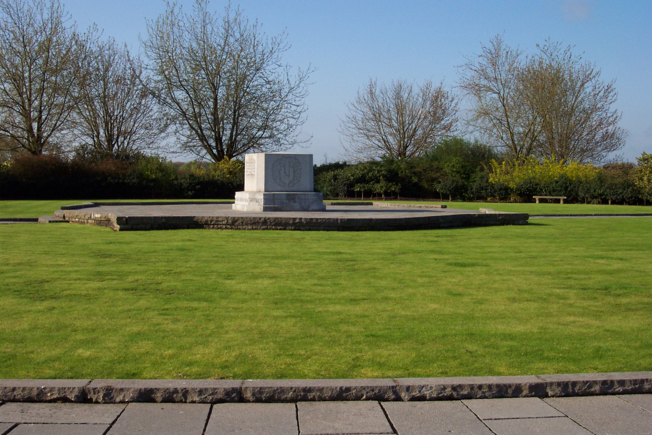
Hill 62 (Sanctuary Wood) Canadian Memorial
Hill 62 (Sanctuary Wood) Canadian Memorial is a block of white Quebec granite weighing almost 15 tonnes, set in a large circle of green lawn at the top of three landscaped terraces, each ablaze with solid beds of roses in season. It bears the inscription:
HERE AT MOUNT SORREL ON THE LINE FROM HOOGE TO ST. ELOI, THE CANADIAN CORPS FOUGHT IN THE DEFENCE OF YPRES APRIL - AUGUST 1916
From the top of the steps leading up to the Hill 62 (Sanctuary Wood) Canadian Memorial, the visitor, looking down past Sanctuary Wood and Maple Copse along the broad spur of Observatory Ridge, can see the church towers of Ypres, five kilometres to the west. A great many of the Canadian headstones in the Maple Copse and Hooge Crater Cemeteries nearby bear a date in June 1916.
Prelude to the Somme - 1916
The Memorial stands in tribute to the sacrifices and achievements of Canadian soldiers in bloody actions fought over a period of five months to keep a determined enemy from gaining possession of the last few square kilometres of Belgian territory still in Allied hands.
Before the Canadians joined the ill-fated operation of the Somme, they were engaged in local offensives in the southern part of the Ypres Salient - from St. Eloi to a point just northwest of Hoge (Hooge) on the Ypres-Menin road, offensives intended to keep the Germans occupied.
At the battle of St. Eloi the Canadian Corps' 2nd Division received its "baptism of fire" in a battlefield of water-filled craters and shell holes. The Canadians, wearing the new steel helmets that had just been introduced, suffered 1,375 casualties in 13 days of confused attacks and counter-attacks over six water-logged mine craters.
For the 3rd Division, the initiation to battle was even more devastating. On the morning of June 2, the Germans mounted an attack to dislodge the Allies from their positions at Mount Sorrel just north of the Ypres-Menin road. In the fiercest bombardment yet experienced by Canadian troops, whole sections of trench were obliterated and the defending garrisons annihilated. Human bodies and even the trees of Sanctuary Wood were hurled into the air by the explosions. As men were literally blown from their positions, the 3rd Division fought desperately until overwhelmed by enemy infantry. By evening, the enemy advance was checked, but the important vantage points of Mount Sorrel and Hills 61 and 62 were lost. A counter-attack by the Canadians the next morning failed; and on June 6, after exploding four mines on the Canadian front, the Germans assaulted again and captured Hooge on the Menin Road.
The newly appointed Commander of the Canadian Corps, Lt-Gen. Sir Julian Byng, determined to win back Mount Sorrel and Hill 62. He gave orders for a carefully planned attack, well supported by artillery, to be carried out by the 1st Canadian Division under the Command of Major-General Currie. Preceded by a vicious bombardment, the Canadian infantry attacked on June 13 at 1:30 a.m. in the darkness, wind and rain. Careful planning paid off and the heights lost on June 2 were retaken. "The first Canadian deliberately planned attack in any force," the British Official History was to record, "had resulted in an unqualified success." The positions regained by the Canadians would remain part of the Allied line in front of Ypres until the massive German offensives in the spring of 1918.
The cost was high. At Mount Sorrel Canadian troops suffered 8,430 casualties.
Directions
Details
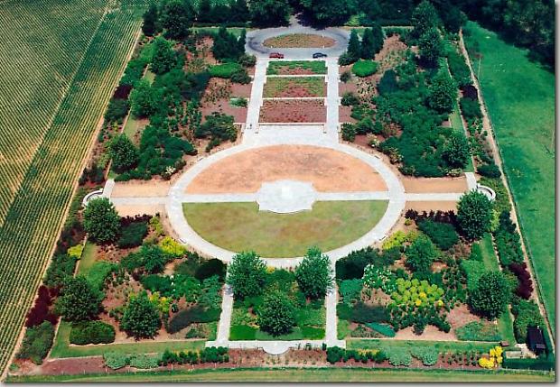
Aerial view of Hill 62 (Sanctuary Wood) Canadian Memorial
The Hill 62 (Sanctuary Wood) Canadian Memorial is about 30 kms north of Lille, 3 kms east of Ypres, 25 kms west of Courtrai and 230 kms north of Paris. You can reach Ypres by train or by bus; the stations are side by side in the centre of the town. The Memorial is about 4.5 km away from the stations. You can reach it by bus, direction Menin (Ligne 722 Bar 1), and you get off at the Bellewaerde stop. You then have to walk for about 10 minutes from the bus stop to get to the Memorial. By taxi, which you can take from the stations, the cost of which is approximately €8 return. You can also rent a bike at the train station; which costs approximately €5 per day, €11 per week and €17 per month.
Note: The cost of a taxi is based on return trips without a waiting period. If you want the taxi to wait for you while you visit the site you will be charged € 20 per hour. In Belgium, Ypres is Ieper, Gand is Gent, Menin is Menen, Roulers is Roeselare, Courtrai is Kortrijk and Lille is Rijsel.
If you are travelling by car, please follow the directions below:
Note: Speed limits in Belgium are 50 km/h in city limits and residential areas, usually 90 km/h on secondary roads (but it may vary in areas) and 120 km/h on the motorway. You should be aware of the priority from the right rule and the presence of cycle lanes (usually unmarked) running alongside the road and generally not separated from it.
From Paris or Charles de Gaulle Airport or Arras take the A1 motorway, direction Lille. As you approach Lille you will take the N17 towards Roulers. Drive for about 20 kms and then take the N8 towards Ypres. On the Ypres / Menin road, you drive for about 12 kms, you then turn south after the traditional Canadian Memorial sign onto Canada Lane (Maple Avenue). The monument is at the end of the Lane. It should take you approximately 2 1/2 to 3 hours to reach the Memorial.
From Ypres take the N8 (Menin Road) and drive for about 3.5 kms. Turn south after the traditional Canadian Memorial sign onto Canada Lane (Maple Avenue). The monument is at the end of the Lane. It should take you approximately 15 minutes to reach the Memorial.
From Courtrai take the N8 and drive for about 23 kms. Turn south after the traditional Canadian Memorial sign onto Canada Lane (Maple Avenue). The monument is at the end of the Lane. It should take you approximately 40 minutes to reach the Memorial.
From Lille take the N17 direction Roulers and continue on this road for approximately 17 kms. Almost immediately after crossing the border, take the N8, direction Ypres. Continue on this road for approximately 15 kms. Turn south after the traditional Canadian Memorial sign onto Canada Lane (Maple Avenue). The monument is at the end of the Lane. It should take you approximately 50 minutes to reach the Memorial.
- Date modified: