Autre

City/Municipality
Delta
Memorial Number
59003-004
Type
Address
856, 56e Avenue
Location
Cimetière de Boundary Bay
in Canada
Oui
GPS Coordinates
49.0180206, -123.0677783
Inscription

[front/devant]

TO THE MEMORY OF
THE MEN AND WOMEN
WHO SERVED IN THE
DEFENSE OF THEIR COUNTRY

MAY LIGHT PERPETUAL SHINE ON THEM

ERECTED BY
MEMBERS AND LADIES AUXILIARY
DELTA/PACIFIC NO 61 BRANCH
ROYAL CANADIAN LEGION, SEPTEMBER 11, 1966

Image
Crédit photo
E.T. Barnes
Légende
front view
War or Conflict Term
!4v1597347171937!6m8!1m7!1s3N2KsGNO5r3mrn4QL1HQLQ!2m2!1d49.0180152773236!2d-123.0677642740519!3f85.29171589826441!4f4.12252955686985!5f1.1924812503605781
Body Content

Ce mémorial est dédié aux combattants. Il a été érigé par les membres et les Dames auxiliaires de la filiale no 61 de la Légion royale canadienne. Les écussons des trois services armés pendant la Seconde Guerre mondiale – l’ARC, la Marine et l’Armée – sont gravés sur les côtés. Le mémorial repose sur une base de béton pentagonale de 7 pouces de hauteur, et dont chacun des cinq côtés mesure 57 pouces de longueur. La base du monument fait 27 pouces carrés et 14 pouces d’épaisseur. Le monument entier, du sol au sommet, s’élève à 10 pieds de hauteur.

City
Delta
Country
Type Description
Obelisk (smooth grey granite)
Memorial CF Legacy ID
6563
City/Municipality
Delta
Memorial Number
59003-003
Type
Address
7800, chemin Alpha
Location
Aéroport de Boundary Bay
in Canada
Oui
GPS Coordinates
49.0808508, -123.0087442
Inscription

AIR CADET COMMEMORATIVE PATHWAY

[interpretive sign/panneau d’interprétation]
Boundary Bay Airport Turns 75

British Commonwealth Air Training Plan
In 1939, four British Commonwealth countries — United Kingdom, Australia, New Zealand, Canada — launched the British Commonwealth Air Training Plan to train Commonwealth aircrews for war. Canada was chosen as the primary location for "The Plan" because of its ideal weather, wide open spaces suitable for flight and navigation training — sometimes on a large scale, ample supplies of fuel, industrial facilities for the production of trainer aircraft, parts and supplies, the lack of any threat from either the Luftwaffe or Japanese fighter aircraft and its relative proximity to both the European and Pacific theatres. Prime Minister William Lyon Mackenzie King supported the plan and absorbed its costs so long as the British acknowledged that air training would be Canada’s primary war effort. Once the plan’s agreement was signed, the Royal Canadian Air Force (RCAF) began establishing airfields across the country for aircrew training schools. In late 1940, the federal government expropriated 480 acres of farmland from three Delta farmers (Patterson, Loney, Fisher) for $69,200 to construct RCAF Station Boundary Bay.

RCAF Station Boundary Bay Construction Gets Underway
The construction of RCAF Station Boundary Bay began on 6 December 1940. Large quantities of rock and gravel ballast were needed to provide a firm base for construction, and hundreds of trucks were used to haul loads of aggregate from the W.A. Kirkland gravel pit near the USA International Border and from a Fraser River barge depot site in Ladner. By 10 April 1941, two runways and a series of gravel roads were operational and civilian flight training was ready to commence. Prime Minister William Lyon Mackenzie King visited RCAF Station Boundary Bay three months later for its official opening on 2 July 1941.

Playing a Dynamic Role during WWII (1941-1945)
Over the course of the war, the airport played a dynamic role — it served as the No. 18 Elementary Flight Training School from 1941-42 where civilians instructors trained RCAF and RAF aircrews; a Home War Aerodrome Unit from 1942-44, charged with defending the West Coast; and as the No. 5 Operational Training Unit from 1944-45, tasked with training aircrews in heavy bomber operations.

Vancouver Wireless Station (1949-1971)
After WWII, the airport was left inactive until it was transferred to the Royal Canadian Corps of Signals in 1949 and re-established as the Vancouver Wireless Station. The site was used to operate radio equipment for communications and signals-intelligence gathering. Staff working at the Vancouver Wireless Station resided with their families on the lands directly north of the airfield — what is now referred to as the North 40 Park Reserve. In 1968, the Canadian Forces unified and the Vancouver Wireless Station site was renamed Canadian Forces Station Ladner. The Ladner Station was permanently closed in 1971.

In 2010, the Corporation of Delta developed a series of information signs for the Vancouver Wireless Station. The project team encourages visitors to explore the North 40 to learn more about its history.

The Corporation of Delta purchases Boundary Bay Airport
In 1972, Transport Canada assumed responsibility for Boundary Bay Airport from the Department of National Defence. Over the next few years, the airfield was leased to a variety of organizations including car-racing clubs, construction companies, driver-training schools, radio-controlled flying clubs, and for wildlife research and agricultural purposes. In 1976, Transport Canada undertook an environmental assessment to determine whether the airport could be reactivated for general aviation. Boundary Bay Airport was reopened five years later on 1 June 1983. Several companies would lease the airport lands from Transport Canada over the next 14 years. On 5 December 1997, Transport Canada transferred ownership of the Boundary Bay Airport to the Corporation of Delta.

Alpha Aviation Inc. Assumes Long-term Airport Lease
On 1 December 2004, Alpha Aviation Inc. assumed a long-term lease of Boundary Bay Airport. Under direction from its Chairman and CEO Fred Kaiser, Alpha Aviation Inc. has made a significant financial investment in the airport, including a $5 million airport terminal, an expanded fuel farm, runway extensions, apron improvements, and runway lighting upgrades. In 12 short years, Alpha Aviation Inc. has turned the airport into a hub of transportation activity. True to its roots, Boundary Bay Airport remains a flight training centre – home to five flight schools – tasked with training a new generation of Canadian pilots.

[interpretive sign/panneau d’interprétation]
No. 18 Elementary Flying Training School (1941-42)

A Flying School Is Launched
After the British Commonwealth Air Training Plan (BCATP) was signed on December 17, 1939, Canadians across the country began to mobilize — an army of experts had to be assembled, airfields developed and equipment, including airplanes, had to be obtained. Civilian flying clubs, airlines and local companies were called upon to establish Elementary Flying Training Schools that could provide the initial basic classroom and flight training to RCAF and RAF recruits. The Aero Club of British Columbia partnered with the Department of National Defence to establish No. 8 Elementary Flying Training School at RCAF Station Sea Island. The Sea Island flying school was considered a half school owing to the busy civilian and RCAF traffic that had priority. Leslie J. Martin, longtime Aero Club member and the elementary flying training school’s manager, made several lobbying trips to Ottawa to make the case for a second BCATP elementary flying school on the West Coast. In late December, the RCAF signed a contract with Martin to establish a second school — No. 18 Elementary Flying Training School — at RCAF Station Boundary Bay. The flying school opened on April 10, 1941 and would soon become one of the largest in Canada. It was held up as the model to which other elementary flying schools would aspire.

Elementary Flying Training School Civilian And RCAF Support
Under agreement with the Government of Canada, Martin’s Boundary Bay Flying Training Company, under the supervision of the RCAF, provided all of the instructors, aircraft operations and maintenance personnel, as well as clerical and accounting staff for the school. In total, more than 200 civilian personnel were needed to operate No. 18 Elementary Flying Training School at RCAF Station Boundary Bay. On opening day, the RCAF also had 98 airmen posted to RCAF Station Boundary Bay. The first RCAF officer in charge was Flight Lieutenant H.A. Beer — his title was Chief Supervisory Officer No. 18 Elementary Flying Training School Boundary Bay.

Learning To Fly
During its eleven months in operation, approximately 730 students passed through No. 18 Elementary Flying Training School at RCAF Station Boundary Bay. The training program lasted seven weeks and saw a new course intake of 70 students every three weeks. Students learned basic flying techniques on one of 64 single-engine two-seat Tiger Moths, logging some 80 hours of flying time over the course of the program. Students also went to Ground Instruction School to learn navigation, signals training, instrumentation, mechanics, and armament.

Elementary Flying Training School Graduates
Students who graduated from No. 18 Elementary Flying Training School attended a BCATP Service Flying Training School to qualify for their coveted pilots’ wings. Graduates found themselves in all theatres of the war, from the deserts of North Africa to the jungles of Burma, and, of course, the busy skies over Europe. Some would go on to establish careers in the RCAF that continued long after the war ended.

No. 18 Elementary Flying Training School Moves To Caron, Saskatchewan
After the attack on Pearl Harbor, panic gripped the West Coast and many people believed that the Japanese had their sights set on Canada. The Canadian Military made efforts to boost defences on the West Coast by converting RCAF Station Boundary Bay and RCAF Station Sea Island into Home War Aerodromes. At the same time, many of the Royal Air Force instructors at No. 33 Elementary Flying Training School in Caron, Saskatchewan were being called back to Europe for combat missions. To fill this instructional void, the No. 18 Elementary Flying Training School and all its civilian instructors were deployed to Caron on April 30, 1941.

Bestowed Decorations
We may never know how many No. 18 Elementary Flying Training School students paid the ultimate sacrifice, but research to date has revealed that at least 102 decorations were bestowed on RCAF Station Boundary Bay alumni, including 11 Distinguished Flying Medals and 63 Distinguished Flying Crosses.

[interpretive sign/panneau d’interprétation]
Home War Aerodrome (1942-44)

After the attack on Pearl Harbour on December 7, 1941, the Canadian Military scrambled to boost defences on the West Coast. Up until then, home defence had been given a low priority. Civilian employment at RCAF Station Boundary Bay would be scaled back as the Royal Canadian Air Force and the Royal Canadian Artillery took over the aerodrome for their defence operations.

Royal Canadian Artillery Anti-Aircraft Regiment
Within weeks of the Japanese attack, the Canadian Military deployed two Anti-Aircraft Regiments to the West Coast (known as Pacific Command) — one to Vancouver Island and the other to Vancouver. The regiments were undermanned and under-resourced because the bulk of Canada’s military resources were sent overseas to assist with the allied war effort in Europe. The 28th Anti-Aircraft Regiment in Vancouver was responsible for the Vancouver, Sea Island, and New Westminster areas, effective June 1, 1942. The regiment’s role was to attack enemy aircraft from the ground using two types of artillery — the heavy 3.7 inch anti-aircraft artillery guns for high-flying bomber aircraft, and the light 40 mm anti-aircraft Bofor guns for lower flying visible targets, such as fighters and dive bombers. By early September 1942, the 21st Battery of the 28th Anti-Aircraft Regiment was established at RCAF Station Boundary Bay and by mid-October 1942 Boundary Bay’s anti-aircraft defences were fully equipped with eight 3.7 inch anti-aircraft guns and twelve 40 mm anti-aircraft Bofor guns.

Royal Canadian Air Force Fighter Squadrons
On July 27, 1942 orders were made to position fighter squadrons at RCAF Station Boundary Bay alongside the already established Royal Canadian Artillery. RCAF Station Boundary Bay officially opened as a Home War Aerodrome on October 1, 1942.

No. 133 Fighter Squadron
No. 133 Fighter Squadron arrived at RCAF Station Boundary Bay on October 5, 1942. The squadron’s first flight from the station occurred on October 11, 1942, when nine Hawker Hurricanes and one Harvard flew together on a two-hour exercise. Much of the squadron’s day-to-day activities included training exercises (e.g., aerial combat, formation flying, height climbs, scrambles), participation in military exercises at Patricia Bay, and dawn and dusk patrols of the coastline. No. 133 Fighter Squadron would later go on to assist with intercepting Japanese Incendiary Fire Balloons (hydrogen balloons carrying incendiary bombs intended to start fires upon landing), which were carried across the Pacific Ocean by the prevailing winds.

No. 132 Fighter Squadron
No. 132 Fighter Squadron arrived at RCAF Station Boundary Bay on July 1, 1943, the day after No. 133 Fighter Squadron departed. It assumed the duty routine established by its predecessor using its Curtiss Kittyhawk fleet. In addition to coastal patrols, the squadron also took part in a number of training exercises involving air attacks on Army troops, bomber escorting, and dive-bombing practice. On October 26, 1943, the squadron participated in a combined exercise operation in which six squadron aircraft strafed and bombed a Royal Canadian Navy landing aircraft.

There were a few intense moments for the squadron during its time at RCAF Station Boundary Bay — on December 18, 1943, RCAF Station Boundary Bay went on high alert, and No. 132 Fighter Squadron was on stand-by in preparation for a possible enemy attack on the West Coast of Vancouver Island, which fortunately did not transpire. The squadron would continue its patrol duties at RCAF Station Boundary Bay until it was transferred to Tofino on March 9, 1944.

No. 14 Fighter Squadron
Also a Curtiss Kittyhawk squadron, No. 14 Fighter Squadron joined No. 132 Fighter Squadron for a short period from September 24, 1943 to December 23, 1943. Before coming to RCAF Station Boundary Bay, the squadron had flown 30 offensive missions against the Japanese on Kiska Island (part of the Aleutian Islands of Alaska).

End Of The Home War Aerodrome Era
In late 1943, the enemy’s naval defeats in the Pacific and the recapture of the Kiska and Attu Aleutian Islands from the Japanese had diminished the threat of an aerial attack on the West Coast. In October 1943, the Royal Canadian Artillery began to scale back Pacific Command anti-aircraft defences, including the withdrawal of twelve Bofor guns remaining at RCAF Station Boundary Bay. By March 1944, the two home defence infantry divisions of Pacific Command were also redistributed to other formations.

The Home War Aerodrome at RCAF Station Boundary Bay transformed into a significant presence on the West Coast over its seventeen months in operation. It had modern fighter aircraft, large hangars for maintenance and storage, and upwards of a dozen H-Hut quarters for personnel. At the height of the defence operation, there were more than 650 people working at the Home War Aerodrome.

Fortunately for the West Coast, an enemy attack never transpired. The Home War Aerodrome at RCAF Station Boundary Bay was ordered to cease operations at the end on March 1944 and prepare for the mobilization of the No. 5 Operational Training Unit.

[interpretive sign/panneau d’interprétation]
No. 5 Operational Training Unit (1944-45)

On April 1, 1944, RCAF Station Boundary Bay became home to No. 5 Operational Training Unit (OTU) — one of the largest bomber flight training schools in the British Commonwealth Air Training Plan. The unit was established to train Commonwealth B-24 Liberator aircrews for RAF Air Command Far East, as well as RCAF Maritime Squadrons and RAF Coastal Command. RCAF Station Boundary Bay was chosen as the headquarters for bomber training because its geography was similar to the flying conditions that aircrews could face overseas: British Columbia had the Coastal Mountains, the Pacific Ocean, the endless West Coast forests, and of course, the rain.

Learning To Fly
During its sixteen months in operation, approximately 4,500 to 4,700 students passed through No. 5 OTU at RCAF Station Boundary Bay. The bomber flight training program lasted 14 weeks and saw a new course intake every two-weeks — 29 courses in total. Aircrew students, other than the Air Gunners, started with ground school instruction and then went on to intermediate flying on the B-25 Mitchell two-engine medium bomber and the B-24 Liberator four-engine heavy bomber. Bomber aircraft instruction began with the usual “circuits and bumps” and progressed to air firing, day and night cross-country navigational flights, and day and night bombing. Bombing practice took place offshore, south of the current BC Ferry and Deltaport causeways, along English Bluff. Once training was complete, No. 5 OTU graduates were assigned to an eleven person RAF B-24 Liberator aircrew that consisted of two Pilots, a Navigator, Bomb-aimer, two Wireless Air Gunners and five Air Gunners.

Abbotsford Satellite Station
RCAF Station Boundary Bay quickly reached maximum capacity making it difficult to accommodate the increase in personnel strength, equipment and services required to operate. On August 15, 1944, RCAF established a satellite station at RCAF Station Abbotsford. From that point forward, students completed the first half of their training on the Mitchell medium bomber aircraft at RCAF Station Boundary Bay and were transferred to RCAF Station Abbotsford to finish their training and graduate on the Liberator heavy bomber aircraft.

RCAF Station Boundary Bay Aircraft
By the end of WWII, dozens of aircraft had passed through No. 5 OTU, including:
• 59 B-24 Liberators
• 70 B-25 Mitchells
• 12 Lancasters
• 12 Curtiss P-40 Kittyhawks (used for fighter affiliation flights)
• 6 Bristol Bolingbrokes (used as target tugs)
• 1 Norseman and 1 Harvard
At the height of operations, No. 5 OTU had more than 100 aircraft on strength.

RCAF Station Boundary Bay Closes
By the summer of 1945, Liberator training had been transferred to No. 6 OTU in Comox and No. 5 OTU began to prepare to train Lancaster crews for the Tiger Force in the Pacific. The first Lancaster bombers began to arrive a few days before V-J Day, but no training was ever done. On September 2, 1945, Japan signed surrender documents to officially end WWII. No. 5 OTU Boundary Bay H.Q. was disbanded two months later on October 31, 1945. The Unit’s diary record for that day provides a fitting closing to the story of RCAF Station Boundary Bay:

Today is “Thirty” for No. 5 Operational Training Unit. Everybody has been struck off strength – except the Perennially Pregnant Puss and her periodically arriving progeny. Flying has ceased. All aircraft have been flown to Abbotsford for storage. There remains now only to clean 3P inventories, winterize, and lock up buildings as they become vacant, and clear the remaining personnel off the station to their new units as their particular job ends. It’s quiet around here, except for the thundering trucks as they haul equipment from barracks and hangars to Stores. Soon the peace and quiet of the grave will settle over this once busiest of stations. Like Gray’s Elegy in a Country Churchyard – and leave the world to darkness, and the small, lonely rear Party and the Perennially Pregnant Puss. No. 5 Operational Training Unit officially died at Midnight Tonight.

J.B. Williamsom) W/C
o.c. R.C.A.F. Station, Boundary Bay, B.C.

[interpretive sign]
Air Cadet League: Early Years

The Establishment Of Air Cadets in Canada
In 1939, the Government of Canada tasked Squadron Leader A.W. “Nick” Carter with establishing the first-ever Air Force Cadet Wing in Canada. The Air Cadet Wing was to be located in Vancouver, British Columbia and its goal was to train high school students to become Royal Canadian Air Force (RCAF) aircrew in preparation for war. A call for applications to join the RCAF Cadet Wing drew more than 1,100 applicants to the Stanley Park Armouries. Squadron Leader Carter handpicked 250 cadets to form the 1601 Wing, Canadian Air Force Cadets which later became 1 Wing and eventually 111 Pegasus Squadron which still parades in Vancouver today. These air cadets made their first public appearance for the Royal Visit of King George VI and Queen Elizabeth on 29 May 1939.

By all accounts, the ‘experimental’ RCAF Air Cadet Wing was a resounding success. On 11 November 1940, an Order-in-Council was passed by the Government of Canada authorizing the formation of the Air Cadet League of Canada. The newly established organization included a national Junior Air Cadet Corps (age 12-14) and Senior Air Cadet Corps (age 15 –18). On 9 April 1941, the Air Cadet League of Canada received its Letters Patent by Dominion Charter from the Government of Canada authorizing it to operate as a charitable, non-profit corporation. A civilian/military partnership was formed to oversee the corporation and a framework was established for nine Air Cadet League of Canada Provincial Committees across Canada.

Shortly after the formation of the BC Provincial Committee, discussions took place with the BC Provincial Department of Education and it was agreed that school boards across the province would deliver the Air Cadet program. In 1941, school district principals and vice principals spent the last two weeks of August receiving intensive training from the RCAF – many of these administrators received their training at RCAF Station Boundary. After passing an examination, administrators became Cadet Civilian Instructors with an officer rank and assumed the position of Commanding Officer for their school’s squadron. As an incentive to students, any air cadet who completed two years of training (288 hours/year), passed all of their courses and achieved a mark of 60% or higher would be given an additional five credits towards graduation.

The Rise of Air Cadet Squadrons
On 25 October 1941, 22 Powell River Squadron became the first British Columbian air cadet squadron to receive its Charter. By the end of December 1941, there were nine active air cadet squadrons in British Columbia. Within a year, this number had tripled to 27. A number of these squadrons were independent squadrons not attached to high schools but sponsored by service clubs such as Royal Canadian Legions, Rotary and Kiwanis. In July 1942, a summer training camp was introduced to the Air Cadet Program. The camp became an intensive study in all areas of interest to the RCAF including meteorology, aero-engine maintenance, navigation, aircraft recognition and range. This spurred continued growth in the Air Cadet program; by the start of the 1944-1945 training year, there were 29,000 Air Cadets enrolled nationally across 374 squadrons, 46 squadrons in British Columbia alone.

[interpretive sign]
Air Cadet League: An Evolving Program

Air Cadettes
Although women were not officially allowed to enter the Air Cadet program until 1975, many photographs taken during WWII show young women in unofficial Squadron or Wing uniforms. These young women, or Air Cadettes, were trained in administration, but pushed for more responsibility and were soon participating in drill first aid and, in some cases, range training.

In 1950, Squadron CO, F/Lt Vince Forbes, lobbied the Royal Canadian Air Force to send Air Cadettes Pat McDowell, Marian Kenmuir and Isobel Pittendreigh from 22 Power River Squadron through the RCAF flight training program. After two years of petitioning, the Royal Canadian Air Force agreed to allow these women to enter the Power Pilot Scholarship Course at Sea Island Airport. All three women completed the course and proudly accepted their Wings at the intake’s Graduation Parade.

On 30 July 1975, the Government of Canada amended the National Defence Act to authorize the provision of support to female cadets by the Department of National Defence. By the end of 1975, there were approximately 4,000 young women enrolled in the Air Cadet Program and 800 of these attended the Air Cadet summer training camp. A total of 60 young women obtained their glider wings that year.

Shifting Focus
When WWII ended, many high school squadrons began to stand down. By the end of the 1945-46 school year, there were only 11,000 Air Cadets enrolled nationally across 155 Squadrons. On 3 July 1946, His Majesty King George VI decreed that the Canadian Air Cadets become the Royal Canadian Air Cadets. The name change created a groundswell of support from ex-cadets, parents, Royal Canadian Air Force personnel and the Air Cadet League of Canada.

The Air Cadets began to shift their focus from providing major ground and aircrew support for the RCAF to providing support to the growing Canadian civil aviation industry. Air Cadet enrollment received another boost when Newfoundland & Labrador joined Confederation – this added another seven squadrons to the Air Cadet League of Canada. By 1950, the number of squadrons in British Columbia stood at 30.

Today, across Canada, the Air Cadet League of Canada continues its partnership with the Department of National Defence to deliver one of the country’s top youth development program to Canadians between the ages of 12-18. Guided by the motto of “To Learn, To Serve, and To Advance” the Air Cadet Program aims to develop leadership, citizenship and physical fitness in an environment that stimulates an interest in the field of aviation and air activities of the Canadian Armed Forces.

Air Cadet Gliding Program
During the summer of 1965, the western Air Cadet squadrons established an experimental gliding program in Penhold, Alberta. The program flourished and received an enormous boost in late 1972 when the Air Cadet League was authorized to purchase, at a nominal price, 17 surplus Cessna L-19 Bird Dog aircraft and 4 surplus Cessna L-182 Skylanes from the Canadian Forces. These were obtained through the Crown Assets Disposal Corporation and continue to play a major role, alongside the League’s other aircraft, in what is now the largest gliding program in the world.

Celebrating 75 Years (1941-2016)
Over the last 75 years, more than one million young Canadians have participated in the Air Cadet program. One in five private pilots in Canada are ex-Air Cadet and 67% of commercial and airline pilots began as Air Cadets. Today, there are 25,890 Air Cadets enrolled nationally across 453 squadrons. Every September, upwards of 16 BC Air Cadet squadrons, approximately 1,000 Air Cadets, participate in the Battle of Britain Commemorative Parade at Boundary Bay Airport to commemorate the day when the Royal Air Force Fighter Command held a decisive victory over the German Luftwaffe – this was a turning point during WWII and a battle fought solely in the air. More than 400 Canadian air and ground crew, including more than 100 pilots fought alongside their Allies to defend England and prevent a planned Nazi invasion.

Image
Crédit photo
City of Delta/Ville de Delta
Légende
Air Cadet Commemorative Pathway
1 sur 5 images
Image
Crédit photo
City of Delta/Ville de Delta
Légende
pathway inscription
1 sur 5 images
Image
Crédit photo
City of Delta/Ville de Delta
Légende
Home War Aerodrome interpretive sign
1 sur 5 images
Image
Crédit photo
City of Delta/Ville de Delta
Légende
No. 5 Operational Training Unit interpretive sign
1 sur 5 images
Image
Crédit photo
City of Delta/Ville de Delta
Légende
No. 18 Elementary Flying Training School interpretive sign
1 sur 5 images
4v1638978978584!6m8!1m7!1sbxRYOV712c4YCTrbs4yzRA!2m2!1d49.08085081197684!2d-123.0087442045719!3f188.42283270746077!4f-6.87885274146376!5f0.7820865974627469
Body Content

Un sentier longe les deux côtés du nouveau cénotaphe et comprend des panneaux d’interprétation présentant des photos et des anecdotes historiques qui commémorent l’histoire de l’aéroport de Boundary Bay et de la Ligue des cadets de l’air du Canada. Vu du ciel, l’ensemble du projet ressemble à l’aigle des logos de la Ligue des cadets de l’air du Canada et de l’Aviation royale du Canada – le cénotaphe au milieu, représentant la tête et le corps de l’aigle, et les sentiers s’étendant à l’est et à l’ouest, représentant les ailes déployées de l’aigle. Le mot « pathway » (sentier) fait écho à la devise de l’Aviation royale canadienne, « Sic Itur Ad Astra », qui se traduit par « Voilà le sentier des étoiles ».

Le financement a été assuré par la Ville de Delta, la Ligue des cadets de l’air du Canada, Alpha Aviation inc., la subvention du Programme de restauration de cénotaphes d’Anciens Combattants Canada et Humphrey Construction Ltd. The Friends of Old Canada a fourni des pierres gravées pour le sentier.

City
Delta
Country
Type Description
Pathway, interpretive panels
Memorial CF Legacy ID
10725
City/Municipality
Richmond
Memorial Number
59003-002
Type
Address
6911, chemin no. 3
Location
Hôtel de ville
in Canada
Oui
GPS Coordinates
49.1632778, -123.1366305
Image
Légende
Remembrance Day Ceremony 1982.
1 sur 5 images
Image
Légende
right side
1 sur 5 images
Image
Légende
left side
1 sur 5 images
Image
Légende
Richmond Cenotaph
1 sur 5 images
Image
Légende
back
1 sur 5 images
!4v1597346604057!6m8!1m7!1sF3Vduw6DE_kuilD30KHu-g!2m2!1d49.1632711645327!2d-123.1366352212942!3f270.5078071971878!4f6.918046536157007!5f0.7820865974627469
Body Content

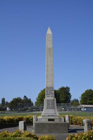
Richmond, comme d’innombrables autres communautés de tout le Canada, a été ébranlée par l’expérience de la Première Guerre mondiale. Dans les années qui ont suivi l’armistice, les anciens combattants de retour au pays se sont regroupés pour former la Great War Veterans Association, qui a décidé en février 1921 d’ériger un monument à la mémoire de « nos camarades de Richmond tombés au combat ». Un comité a été constitué et d’autres organisations ont été pressenties : l’IODE, l’association des contribuables, la Croix-Rouge et le conseil de Richmond. Le comité a demandé au conseil municipal de Richmond un emplacement devant l’hôtel de ville, relativement nouveau à l’époque, et l’a obtenu en novembre 1921.

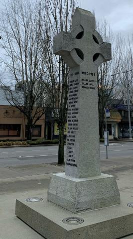
Le président du comité du mémorial, le révérend A. MacKay, a indiqué lors de sa comparution devant le conseil, le 20 février 1922, que le monument aux morts coûterait 1 612 $, ce qui incluait la colonne elle-même, avec les inscriptions appropriées, la base de ciment et les blocs de granit. Le conseil a accordé une somme de 300 $ au comité, et les 1 312 $ restants ont été recueillis grâce à une souscription publique et à une campagne générale de financement. Une croix celtique, conçue par le cabinet d’architectes Sharp and Thompson de Vancouver en Colombie?Britannique, a été achetée auprès de l’Independent Monument Company. La base en béton a été achevée le 15 mars 1922, la colonne a été érigée et quatre blocs de granit ont été gravés pour commémorer des batailles clés de la Grande Guerre. La base du monument est en granit et elle repose sur une plate?forme en béton élevée à deux marches du sol.

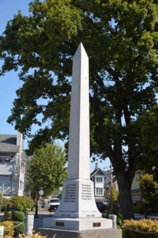
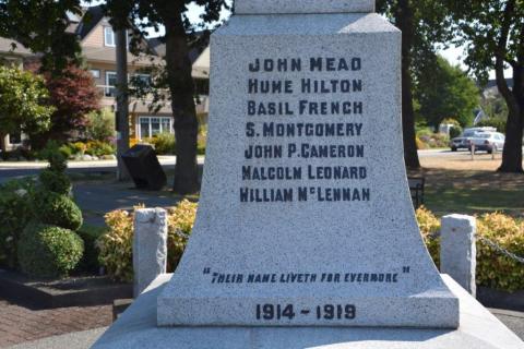
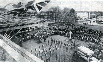
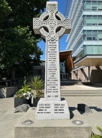
La date du 9 avril 1922, dimanche de Pâques, a été retenue pour la cérémonie d’inauguration puisqu’elle était très proche de l’anniversaire de la bataille de la crête de Vimy. Au cours de la cérémonie d’inauguration, le cénotaphe a été dévoilé par Mary et Gordon Hayne, les enfants de James Arthur Hayne, un pêcheur de Steveston tué au combat en France en mai 1917. Le mémorial portait à l’origine 22 noms, auxquels quatre se sont ajoutés plus tard. À la fin de la Seconde Guerre mondiale, de nouveaux noms y ont été inscrits sur les faces nord et sud – 32 immédiatement après la guerre et quatre autres en 1949. Le mémorial a été restauré en 1998. 

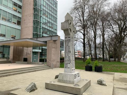
Le 15 juillet 1999, le cénotaphe a été temporairement déplacé de l’hôtel de ville à l’atelier de son créateur, William Chandler de W.R. Monuments commémoratifs à Vancouver. Il a été réinstallé sur le site en 2000, lorsque le nouvel hôtel de ville a été achevé.  Le 30 mai 2024, deux noms ont été ajoutés au recto du cénotaphe.

Les archives de la ville de Richmond ont publié un livre illustré présentant l’historique du cénotaphe et les biographies de la plupart des hommes dont les noms sont gravés dessus. On y trouve aussi la biographie de sept personnes dont les noms ne figurent pas encore sur le monument.

City
Richmond
Country
Type Description
Cross (Celtic) - granite
Photo Credit
Ville de Richmond
Memorial CF Legacy ID
1315
City/Municipality
Delta
Memorial Number
59003-001
Type
Address
Avenue 47 et rue Delta
Location
Parc commémoratif
in Canada
Oui
GPS Coordinates
49.0883052, -123.0850105
Inscription

[front/devant]

ROSS BAXTER
FREDERICK BEMI
JOHN CHRISTIAN
ERIC COLE
BERT FREDERICK
MAXWELL LOVE

1939-1945

JOHN E.FALK
CYRIL MOORE
STANLEY SMITH
SIDNEY N.RICH
ROBERT KETTLES
FRED W.WHITWORTH
LESTER W.HANDFORD

"THEIR NAME LIVETH FOR EVERMORE"

1914-1919

(plaque)

IN MEMORY OF
THOSE WHO SERVED AND DIED FROM
DELTA
IN KOREA

[right side/côté droit]

JOHN MEAD
HUME HILTON
BASIL FRENCH
S.MONTGOMERY
JOHN P.CAMERON
MALCOLM LEONARD
WILLIAM MCLENNAN

"THEIR NAME LIVETH FOR EVERMORE"

1914-1919

(plaque)

IN MEMORY OF
THOSE WHO SERVED AND DIED FROM
DELTA
IN NATO MISSIONS

[back/derrière]

FRED A.COOK
GUY A.TAYLOR
SIDNEY WELSH
WILLIAM LEWIS
NEIL MCNIVEN
ROBERT SCOTT

"THEIR NAME LIVETH FOR EVERMORE"

1914-1919

(plaque)

IN MEMORY OF
THOSE WHO SERVED AND DIED FROM
DELTA
IN AFGHANISTAN CONFLICTS

[left side/côté gauche]

LESLIE MCCREA
DONALD MONTGOMERY
HOMER E.ROBISON
DAVID SKINNER
WALTER WILLIAMS

1939-1945

CECIL WEARE
ARTHUR MILLS
J.C.SMALLWOOD
DOUGLAS A.WRIGHT
EDWIN E.HUTCHERSON

WILLIAM S.MONTGOMERY

GEOFFREY W.MCCALLAN


"THEIR NAME LIVETH FOR EVERMORE"

1914-1919

(plaque)

KOREA
1950-1953

Image
Légende
Delta Cenotaph
1 sur 5 images
Image
Légende
front and left side
1 sur 5 images
Image
Légende
right side plaque
1 sur 5 images
Image
Légende
back inscription
1 sur 5 images
Image
Légende
right side inscription
1 sur 5 images
!4v1597345455666!6m8!1m7!1suchdts4jbLmmWS-qMlupqg!2m2!1d49.08835448308845!2d-123.0850672663574!3f184.2872461035534!4f3.7502085528051623!5f1.9587109090973311
Body Content

À l’origine, le parc commémoratif était la propriété de William Henry Ladner. En 1919, Harry Nelson Rich, un éminent homme d’affaires du village qui a perdu son fils unique, Sidney, pendant la Première Guerre mondiale, a obtenu la superficie pour l’exploiter en tant que mémorial administré par la Delta Memorial Park Association. Le cénotaphe a été dévoilé lors d’un grand rassemblement communautaire le 22 mai 1921. Vingt-sept noms des résidents de Delta morts pendant la Première Guerre mondiale ont été gravés dans le granit. Plus tard, les noms de ceux qui sont morts pendant la Seconde Guerre mondiale ont été ajoutés et la guerre de Corée, la mission en Afghanistan et l’OTAN ont été reconnues.

L’association de bénévoles a exploité le parc et a entretenu le cénotaphe jusqu’en 1956, lorsque la propriété et les biens ont été remis à la Corporation de Delta. Le cénotaphe a été rénové et aménagé en 1987 par la Légion et d’autres bénévoles.

City
Delta
Country
Type Description
Obelisk
Photo Credit
Gary Bramhill
Memorial CF Legacy ID
7813
City/Municipality
100 Mile House
Memorial Number
59002-025
Type
Address
265, avenue Birch
Location
100 Mile Salle Communautaire, mur extérieur
in Canada
Oui
GPS Coordinates
51.6440775, -121.2955661
Image
Crédit photo
100milefreepress.net
Légende
Royal Canadian Legion 100 mile community hall mural in South Cariboo 2011
War or Conflict Term
!4v1597345009213!6m8!1m7!1sTsju8QO9WtHPDWibTWui2A!2m2!1d51.64407545808474!2d-121.2955677815465!3f78.2844848884688!4f-2.2557508097974334!5f1.1924812503605781
Body Content

The Legion mural on the south wall of the 100 Mile Community Hall, on the corner of Birch Avenue and Third Street, was funded by the local 100 Mile Legion. It was painted by Dwayne Davis and Neil Pinkett in 2011. Royal Canadian Legion Branch #260 commemorates and pays homage to our past and serving veterans who serve so bravely on land, air and sea. Depicted are two of 100 Mile veterans Ernie Sampson (Ret. Navy) and Gordon Thorsteinson (Ret. Air Force).

City
100 Mile House
Country
Type Description
Mural
Memorial CF Legacy ID
10272
City/Municipality
Port Edward
Memorial Number
59002-024
Type
Address
Lac Colonel Johnston
Location
Au sud de Prince Rupert
in Canada
Oui
GPS Coordinates
54.2030128, -130.1788324
Inscription

On maps: Colonel Johnston Lake

Image
Crédit photo
Richard Turcotte
Légende
Map - Location of Colonel Johnston Lake (map by NR Can)
Body Content

Le lac Colonel Johnston Lake est nommé à la mémoire du lieutenant?colonel Sydney Douglas Johnston, MC avec barrette

Sydney Douglas Johnston est né en avril 1896 à Vancouver. Lorsque la Première Guerre mondiale éclate, il s’enrôle dans le 72e Bataillon du Seaforth Highlanders, mais il est réaffecté dans le 16e Bataillon du Canadian Scottish Regiment et sert sous les ordres du lieutenant?colonel Cyrus Wesley Peck, VC. Le 16e Bataillon s’embarque pour le Royaume?Uni au début d’octobre 1914 et s’entraîne sur la plaine de Salisbury jusqu’à ce qu’il s’embarque pour la France au milieu de février 1915. Le Bataillon prend part à tous les principaux combats du Corps canadien, notamment à Ypres, à la Somme, à Vimy et à Passchendaele. Ayant obtenu une commission sur le terrain, c’est pendant une de ces batailles que Johnston a été gravement blessé en 1916 et qu’il s’est vu par la suite décerner la Croix militaire et plus tard une barrette à la Croix militaire. À son retour au Canada, le major Johnston s’installe à Prince Rupert et met sur pied une compagnie d’assurance et d’immobilier. En 1932, en tant que lieutenant?colonel, il prend le commandement du 102e Bataillon qui devient plus tard une unité d’artillerie antiaérienne lourde et qui, sous son commandement, devait défendre le port vital de Prince Rupert pendant la Seconde Guerre mondiale. Il demeure à Prince Rupert après la guerre et prend sa retraite en 1957. Le lieutenant?colonel Sydney D. Johnston est décédé en novembre 1966 à Vancouver.

Carte – Emplacement du lac Colonel Johnston Lake (carte par RNCan)

City
Port Edward
Country
Type Description
Geographic location
Memorial CF Legacy ID
9349
City/Municipality
Port Edward
Memorial Number
59002-023
Type
Address
Crique Colonel Johnston Creek
Location
Au sud de Prince Rupert
in Canada
Oui
GPS Coordinates
54.2059863, -130.1552651
Inscription

On maps: Colonel Johnston Creek

Image
Crédit photo
Richard Turcotte
Légende
Map - Location of Colonel Johnston Creek (map by NR Can)
Body Content

La crique Colonel Johnston est nommée à la mémoire du lieutenant?colonel Sydney Douglas Johnston, MC avec barrette.

Sydney Douglas Johnston est né en avril 1896 à Vancouver. Lorsque la Première Guerre mondiale éclate, il s’enrôle dans le 72e Bataillon du Seaforth Highlanders, mais il est réaffecté dans le 16e Bataillon du Canadian Scottish Regiment et sert sous les ordres du lieutenant?colonel Cyrus Wesley Peck, VC. Le 16e Bataillon s’embarque pour le Royaume?Uni au début d’octobre 1914 et s’entraîne sur la plaine de Salisbury jusqu’à ce qu’il s’embarque pour la France au milieu de février 1915. Le Bataillon prend part à tous les principaux combats du Corps canadien, notamment à Ypres, à la Somme, à Vimy et à Passchendaele. Ayant obtenu une commission sur le terrain, c’est pendant une de ces batailles que Johnston a été gravement blessé en 1916 et qu’il s’est vu par la suite décerner la Croix militaire et plus tard une barrette à la Croix militaire. À son retour au Canada, le major Johnston s’installe à Prince Rupert et met sur pied une compagnie d’assurance et d’immobilier. En 1932, en tant que lieutenant?colonel, il prend le commandement du 102e Bataillon qui devient plus tard une unité d’artillerie antiaérienne lourde et qui, sous son commandement, devait défendre le port vital de Prince Rupert pendant la Seconde Guerre mondiale. Il demeure à Prince Rupert après la guerre et prend sa retraite en 1957. Le lieutenant?colonel Sydney D. Johnston est décédé en novembre 1966 à Vancouver.

Carte – Emplacement de la crique Colonel Johnston Creek (carte oar RNCan)

City
Port Edward
Country
Type Description
Geographic location
Memorial CF Legacy ID
9348
City/Municipality
Gold River
Memorial Number
59002-022
Type
Address
Mont Colonel Foster
Location
13 km sud-est de Gold River
in Canada
Oui
GPS Coordinates
49.7500409, -125.8694276
Image
Crédit photo
Richard Turcotte
Légende
Map - Location of Mount Colonel Foster (map by NR Can)
Body Content

Le mont Colonel Foster est nommé en l’honneur du major?général (alors lieutenant?colonel) William W. Foster, CMG, DSO à deux barrettes, MC, Croix de Guerre (France), Croix de Guerre (Belgique).

William Washborough (parfois appelé Wasbrough) Foster est né en Angleterre en 1875 et est venu s’installer au Canada en 1892 pour travailler pour la compagnie de chemin de fer Canadien Pacifique à Revelstoke, en Colombie?Britannique. Dans les années qui ont suivi, il a occupé différents postes civils, notamment juge de paix et magistrat de police. En 1910, il devient sous?ministre pour le ministère des Travaux publics de la Colombie?Britannique et est élu à l’Assemblée législative de la Colombie­Britannique en 1913. Lorsque la Première Guerre mondiale éclate, Foster s’enrôle dans le 2e Bataillon du Canadian Mounted Rifles (CMR). Il part pour l’Angleterre en juin 1915 et arrive en France en septembre de la même année. Ce régiment faisait partie de la 3e Division du Canada et a combattu partout en France et dans les Flandres, notamment dans la bataille du Mont Sorrel, la bataille de Flers-Courcellette, la bataille de la crête de Thiepval, la bataille de la crête de Vimy et la bataille de la Scarpe. En août 1917, Foster est nommé commandant du 52e Bataillon (Corps expéditionnaire canadien), un poste qu’il conserve jusqu’à ce que l’unité soit démobilisée en 1918. À son retour au Canada, il devient président d’une firme d’ingénierie et président de différentes organisations, notamment la Légion et le Club alpin du Canada. Il reprend le service pendant la Seconde Guerre mondiale comme président du jury de sélection des officiers canadiens et est plus tard promu au grade de major?général responsable de la région Nord?Ouest du Canada. Après la guerre, il devient chef de la BC Hydro-Electric Power Commission et entreprend beaucoup de grands projets d’ingénierie. Il était également un remarquable alpiniste et a participé à la première escalade du mont Robson en 1913 et du mont Logan en 1925. William Washborough Foster est décédé à Vancouver le 2 décembre 1954 à l’âge de 79 ans.

Carte – Emplacement du Mount Colonel Foster (carte par RNCan)

City
Gold River
Country
Type Description
Geographic location
Memorial CF Legacy ID
9346
City/Municipality
Port Edward
Memorial Number
59002-021
Type
Address
Lac Peck
Location
20 km au sud de Prince Rupert
in Canada
Oui
GPS Coordinates
54.1723146, -130.1372415
Inscription

On maps: Peck Lake

Image
Crédit photo
Richard Turcotte
Légende
Map - Location of Peck Lake (map by NR Can)
War or Conflict Term
Body Content

Le lac Peck est nommé en l’honneur du lieutenant?colonel Cyrus Wesley Peck, VC, DSO et barrette.

Cyrus Wesley Peck est né en avril 1871 à Hopewell Hill, au Nouveau?Brunswick. En 1887, il s’installe avec sa famille à New Westminster, en Colombie?Britannique. Dès son jeune âge, il tente de joindre l’armée britannique et se porte volontaire pour la guerre des Boers, mais son enthousiasme à devenir militaire demeure vain. Il habite plus tard le nord du Canada et par la suite il habite Prince Rupert lorsque la Première Guerre mondiale éclate. Il s’enrôle comme capitaine en novembre 1914 et est envoyé outre?mer avec le 30e Bataillon du Corps expéditionnaire canadien. En avril 1915, il est promu major et transféré peu après au 16e Bataillon du Canadian Scottish Regiment. En janvier 1916, il est nommé commandant du 16e Bataillon. Pendant son service outre?mer, le lieutenant?colonel Peck qui se voit décerner l’Ordre du service distingué avec barrette, est cité à l’ordre du jour à cinq reprises et est blessé deux fois. Cependant la raison pour laquelle on se souvient le plus de lui, ce sont ses actes du 2 septembre 1918 à Cagnicourt, en France (ligne Drocourt-Queant) où son leadership et son courage sous le tir ennemi ont conduit au succès de l’assaut et lui ont valu la Croix de Victoria (voir la référence ci?dessous). Ayant été élu membre du Parlement en 1917 en tant que soldat candidat, Peck entreprend sa carrière politique à la fin de la Première Guerre mondiale. Il est élu à l’Assemblée législative de la Colombie?Britannique en 1924 et en 1928. Après sa carrière politique, il est nommé à la Commission canadienne des pensions. Cyrus Wesley Peck est décédé en septembre 1956 et ses cendres ont été dispersées sur la côte de Prince Rupert. 

« Pour sa bravoure exceptionnelle et son habile commandement alors qu’il menait un assaut sous le feu nourri de l’ennemi.

Son unité s’est rapidement emparée d’un premier objectif, mais n’arrivait pas à gagner le suivant en raison de tirs de mitrailleuses ennemies sur son flanc droit.

Dans une situation devenue extrêmement critique, le Lcol Peck a poursuivi son avancée et effectué personnellement une reconnaissance sur une étendue de terrain balayée par le feu intense de mitrailleuses et de tireurs d’élite.

Après sa sortie, il est revenu afin de réorganiser son bataillon et, grâce aux informations acquises en reconnaissance, a pu le pousser de l’avant tout en prenant les dispositions nécessaires pour en protéger les flancs. Il est ensuite parti à la rencontre des chars sous un feu toujours nourri de mitrailleuses et d’artillerie afin de les diriger vers leurs objectifs et de permettre au bataillon canadien d’infanterie d’aller de l’avant. Il a enfin apporté le soutien nécessaire à ce bataillon.

Ce superbe acte de courage et les excellentes qualités de chef du Lcol Peck ont permis aux troupes de continuer leur progression malgré le feu de l’artillerie lourde et des mitrailleuses, et a largement contribué à la réussite de l’assaut mené par la brigade ».

(London Gazette, n31012, 15 novembre 1918)

Carte – Emplacement du lac Peck (carte par RNCan)


City
Port Edward
Country
Type Description
Mountain
Memorial CF Legacy ID
9345
City/Municipality
Gold Bridge
Memorial Number
59002-020
Type
Address
Mont Scherle
Location
20 km à l’ouest du pont Gold
in Canada
Oui
GPS Coordinates
52.86694, -123.15528
Body Content

Le mont Scherle est ainsi nommé en l’honneur du soldat William P. Scherle, tué dans un accident d’hélicoptère le 7 juillet 1970, au cours d’une mission d’arpentage. Le sommet de 2 743 mètres qui surplombe le site de l’accident a reçu le nom de mont Scherle le 30 décembre 1970.

City
Gold Bridge
Country
Type Description
Mountain
Memorial CF Legacy ID
6886