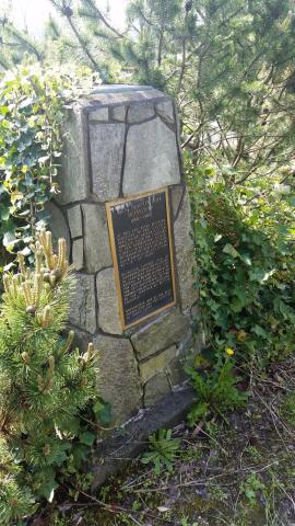
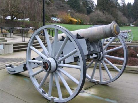
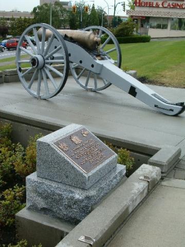
Ce monument commémoratif a été érigé en 2004 par la Royal Westminster Regiment Historical Society, pour rappeler la restauration de deux obusiers de campagne de 24 livres. Voir l’inscription sur la plaque pour obtenir de plus amples détails.
Canons Howitzer du NSM Sparrowhawk
City/Municipality
New Westminster
Memorial Number
59013-036
Type
Address
511, avenue Royal
Location
Esplanade devant l’hôtel de ville
in Canada
Oui
GPS Coordinates
49.2062559, -122.9101138
Inscription
[plaque/plaque]
24 POUNDER FIELD HOWITZERS
THESE TWO GUNS ARRIVED IN NEW WESTMINSTER IN 1866
ON BOARD THE HMS SPARROWHAWK.
THEY WERE USED FOR TRAINING AND LOCAL DEFENSE
UNTIL 1873 BY THE SEYMOUR ARTILLERY COMPANY.
A PREDECESSOR OF
THE ROYAL WEST MINSTER REGIMENT.
RESTORATION OF THE GUNS COMPLETED IN 2004 BY
THE ROYAL WESTMINSTER REGIMENT HISTORICAL SOCIETY
THANKS TO MAJOR SPONSORS
THE CITY OF NEW WESTMINSTER
AND
THE MILLENNIUM COMMITTEE
Image
Crédit photo
Capt Chuck MacKinnon
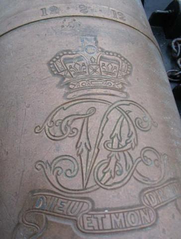
Légende
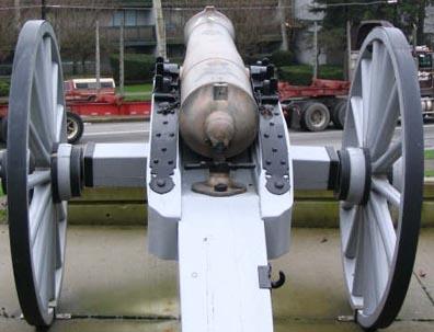
front view
1
sur
5
images
Image
Légende
inscription
1
sur
5
images
Image
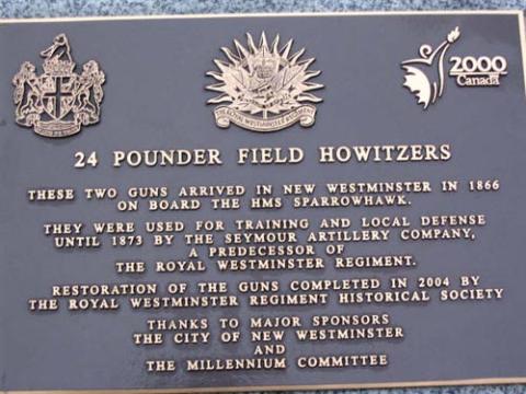
Légende
plaque
1
sur
5
images
Image
Légende
back view
1
sur
5
images
Image
Crédit photo
Harry Palmer; Ted Usher
1
sur
5
images
Province
!4v1620653964681!6m8!1m7!1sYf4sS8Ul4bORcl67lZxBMQ!2m2!1d49.20625590810103!2d-122.910113847908!3f299.1967224117757!4f7.955376778117724!5f1.2655885904933201
Body Content
City
New Westminster
Country
Display photo gallery on sidebar
Off
Type Description
Bronze plaque/24 Pounder Field Howitzers
Memorial CF Legacy ID
7841