For Tim Joyce, President of Sound Venture Productions, the connection is personal. “My great uncle fought at Vimy, and he was killed the night before the battle on a night raid,” he says. “A hundred years later, to the day, I stood at his grave. That was a very moving experience for me.”
Tim had been brought to this now-serene countryside by the Royal Canadian Air Force as part of the centennial celebrations of the Battle of Vimy Ridge. His role was to promote a series of documentaries, plane replicas and maps developed by Sound Venture, in partnership with the RCGS, but his great uncle was not far from his mind.
On a dangerous raid, Lieutenant Alfred Philip Gibaut would have used one of the most important weapons in the Allied soldiers’ arsenal: detailed maps of the enemy’s trenches, fortifications, and artillery, only recently made available through aerial reconnaissance.
The role of aerial mapping evolved quickly from 1914 to 1918. Allied high command originally dismissed it as unimportant, but soon realized that knowing the exact location of a machine gun nest or artillery piece was key to avoiding or destroying it. Canadians took a leading role in this transformation of war, with thousands of Canadian pilots and topographic surveyors contributing to mapping the front lines. The skills they developed opened the way for mapping Canada’s largely uncharted wilderness in the decades after the war.
A Nation Soars
With the centenary of the First World War, Sound Venture saw an opportunity to shed light on this unique part of Canadian military history. In partnership with the RCGS, Sound Venture launched A Nation Soars, a three part documentary that details the technological and tactical advances in Canadian combat and reconnaissance aviation in the war. Sound Venture produced the documentary, while RCGS took care of design and distribution, leveraging its network of 23,000 teachers across Canada, and wide recognition of its flagship publication, Canadian Geographic.
As Ellen Curtis of Canadian Geographic says, the RCGS took an interest in the project because “history must happen somewhere—and geography played an important role in both the World Wars. Also, many Canadians had grandparents and great-grandparents in the wars, but young people don’t always have the same connection that helps us to remember and honour their stories.”
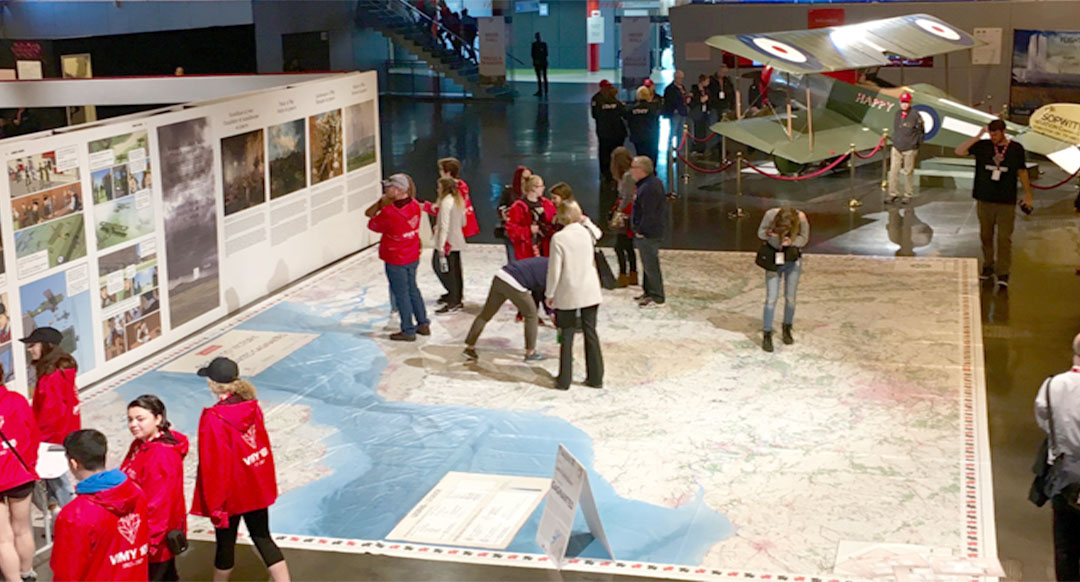
The documentaries led to two spinoff projects: the construction of some replica Sopwith Pup biplanes, in partnership with the Air Cadets, and the development of two giant floor maps for classroom use.
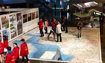
Giant maps: from the sky, to the trenches, to the classroom floor
One of the giant floor maps, Drawn to Victory, depicts the Western Front of the war; the other shows Vimy Ridge. Both come in classroom (5m x 4m) and giant (11m x 8m) formats, and are replicas of the kind of map that a soldier might carry in his pocket in the trenches. Each map comes with a teacher’s guide, photo and fact cards, and 10 learning activities—all aimed at making the war more accessible for a young audience.
The floor maps are available on three week loans through Canadian Geographic. “Each map goes to 20 schools per year,” says Ellen, “and about 50 to 100 students use it for each visit. Some schools invite other schools in to see the map when they have it.” She notes that having a map to walk around, and interact with, is far more engaging than memorizing names and dates from a book; there’s also a personal connection, as many of the students will realize that the map is a replica of something that might have been carried by a peer of the same age group, in a trench far from a high school gymnasium.
The VAC Commemorative Partnership Program
While the documentaries of A Nation Soars were well received, the floor maps are the project’s legacy, as they continue to be circulated to schools, free of charge. To make this possible, Sound Venture drew on support from VAC’s Commemorative Partnership Program, which provides funding to support community commemorative activities and war memorials.
“VAC played a large role in sustaining momentum,” says Tim. “Without this support, those maps would be sitting in a warehouse, doing nothing. We needed Commemorative Partnership Program funding to get them across to the teacher network.”
A legacy, perhaps, but Tim says that Sound Venture isn’t finished working on commemoration. “There’s a great appetite for more education in Canada’s history and war history in particular. We never want to stop promoting opportunities to learn.”
Support for community projects
Organizations planning similar projects can apply for support through the Commemorative Partnership Program. Funding is available for:
- Community Engagement projects – such as educational events or storytelling initiatives
- Community War Memorials projects – such as restoring or building monuments
To learn more or apply, visit Commemorative funding programs.