
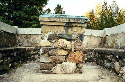
This monument, a bronze three-dimensional map on a stone shaft surrounded by a stone wall, was erected in 1948. It is dedicated to Colonel Benjamin Benton Morrill (1868-1941) and his wife Florence Humphrey (1871-1941). Born in Dufferin Heights, Morrill joined the military and eventually commanded the Stanstead Squadron of Cavalry and the 13th Scottish Light Dragoons who won the ``Turner Shield`` six years in a row, the greatest honour awarded to a cavalry unit of the Canadian Militia. After his retirement, he worked in real estate and wood industry in Sherbrooke. He founded the Stanstead County Historical Society in 1929 and became its first president.

memorial (surroundings)
Jacinthe Choinière1
of
4
images
stone shaft (front)
1
of
4
images
plaque (right side)
1
of
4
images

plaque (left side)
1
of
4
images
Type
Colonel Benjamin Benton Morrill Memorial
Stanstead, Québec
Inscription
[plaque/plaque]
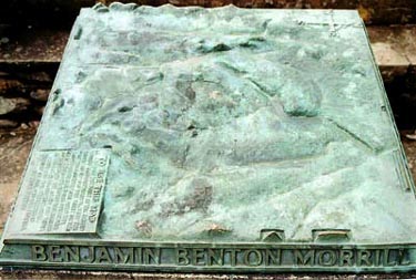
IN MEMORY OF COLONEL BENJAMIN BENTON MORRILL 1868-1941 AND HIS WIFE JESSIE FLORENCE HUMPHREY 1871-1941
TO USE THIS MAP, LOOK ACROSS THE POINT IN THE CENTER MARKED DUFFERIN HEIGHTS. THEN THE MOUNTAIN BEYOND THE POINT ON THE MAP WILL CORRESPOND THE MOUNTAIN IN THE SAME DIRECTION OF THE HORIZON, NAMES AND HEIGHTS OF THE MOUNTAINS ARE GIVEN AND THEIR DISTANCES IN MILES FROM HERE.
THIS MAP WAS PRESENTED IN MEMORY OF COL. AND MRS. MORRILL BY THEIR FRIENDS
ORSON WHEELERS, 1948.
Location
Colonel Benjamin Benton Morrill Memorial
4115 Route 143
Stanstead
Québec
Colonel Benjamin Benton Morrill Memorial
4115 Route 143
Stanstead
Québec
GPS Coordinates
Lat. 45.0068187
Long. -72.0988386
Lat. 45.0068187
Long. -72.0988386