
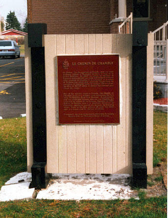
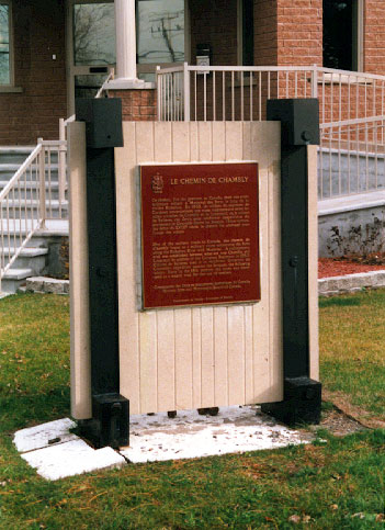
This memorial, which was originally erected by the Historic Sites and Monuments Commission of Canada in 1935 and replaced in 1974, is dedicated to the memory of the "Chambly Road" (chemin du Chambly) as a military route joining the Richelieu region with Montreal.
Chambly Road Memorial Plaque
Saint-Hubert, Québec
Inscription
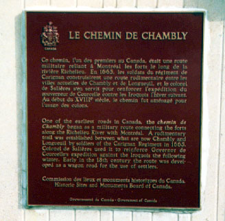
LE CHEMIN DE CHAMBLY
Ce chemin, l'un des premiers au Canada, était une route militaire reliant à Montréal les forts le long de la rivière Richelieu. En 1665, les soldats du régiment de Carignan construisirent une route rudimentaire entre les villes actuelles de Chambly et de Longueuil, et le colonel de Salières s'en servit pour renforcer l'expédition du gouverneur de Courcelle contre les Iroquois l'hiver suivant. Au début du XVIIIe siècle, le chemin fut aménagé pour l'usage des colons.
One of the earliest roads in Canada, the chemin de Chambly began as a military route connecting the forts along the Richelieu River with Montréal. A rudimentary trail was established between what are now Chambly and Longueuil by soldiers of the Carignan Regiment in 1665, Colonel de Salières used it to reinforce Governor de Courcelle's expedition against the Iroquois the following winter. Early in the 18th century the route was developed as a wagon road for the use of settlers.
Street View
Location
Chambly Road Memorial Plaque
7500 Chambly Road
Saint-Hubert
Québec
Chambly Road Memorial Plaque
7500 Chambly Road
Saint-Hubert
Québec
GPS Coordinates
Lat. 45.490442
Long. -73.3893394
Lat. 45.490442
Long. -73.3893394