
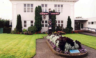
In the late summer of 1985, in conjunction with the 75th Anniversary of the Royal Canadian Navy's naval presence in Esquimalt, the Chief and Petty Officers' Association erected a Totem Pole on the grounds in front of Esquimalt Municipal Hall. On May 28, 1989, the second half of the planned project took place: The Sailors' Walk. The names of all the navy ships lost during the Second World War (starting with HMCS Fraser and ending with HMCS Esquimalt) were inscribed on brass plates and mounted on a small retaining wall surrounding a flower bed.
Plaque
Dave Parker; Susan Green1
of
6
images
Rick Daykin (Township of Esquimalt)
1
of
6
images
Rick Daykin (Township of Esquimalt)
1
of
6
images
Rick Daykin (Township of Esquimalt)
1
of
6
images
large plaque
Rick Daykin (Township of Esquimalt)1
of
6
images
Rick Daykin (Township of Esquimalt)
1
of
6
images
Type
Esquimalt Sailors' Walk
Esquimalt, British Columbia
Notice:
The National Inventory of Canadian Military Memorials is a public, crowd-sourced registry that helps Canadians learn about memorials in their communities. Inclusion in the Inventory does not imply VAC ownership or authority. Responsibility for the care, management, and any changes to a memorial rests with its owning or governing organization.
Inscription
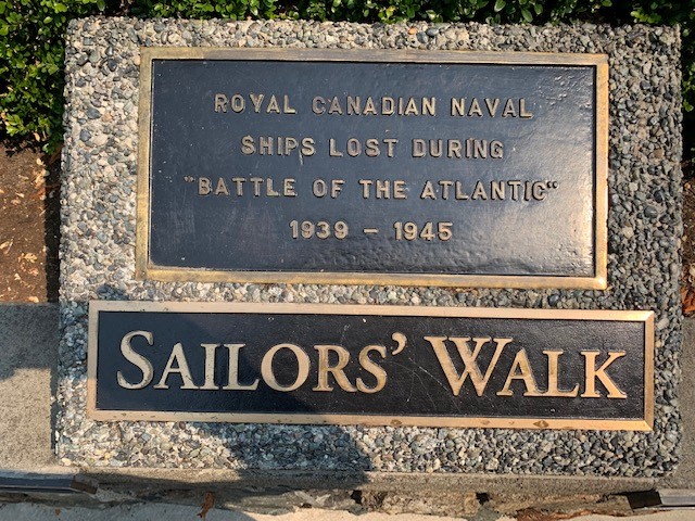
[large plaque/grande plaque]
ROYAL CANADIAN NAVAL
SHIPS LOST DURING
"BATTLE OF THE ATLANTIC"
1939-1945
SAILORS' WALK
[plaque]
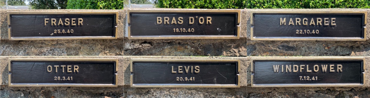
FRASER
25.6.40
[plaque]
BRAS D'OR
19.10.40
[plaque]
MARGAREE
22.10.40
[plaque]
OTTER
26.3.41
[plaque]
LEVIS
20.9.41
[plaque]
WINDFLOWER
7.12.41
[plaque]
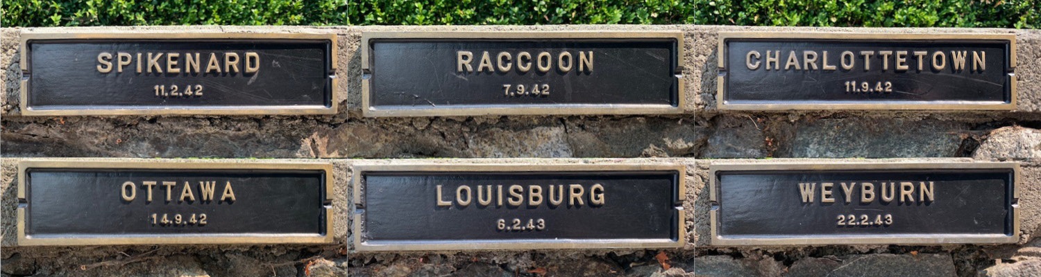
SPIKENARD
11.2.42
[plaque]
RACCOON
7.9.42
[plaque]
CHARLOTTETOWN
11.9.42
[plaque]
OTTAWA
14.9.42
[plaque]
LOUISBURG
6.2.43
[plaque]
WEYBURN
22.2.43
[plaque]
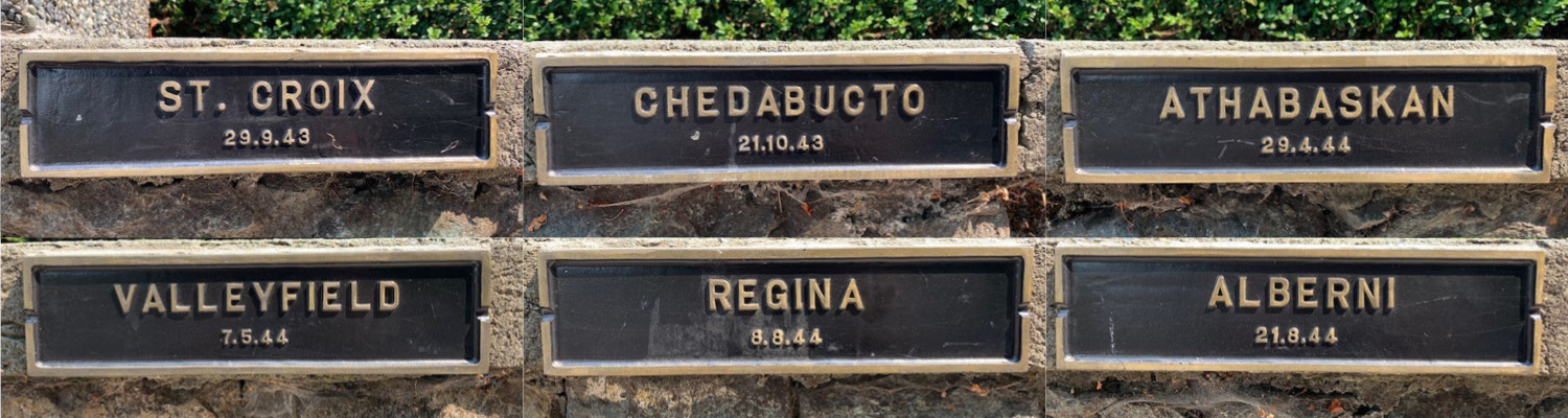
ST. CROIX
29.9. 43
[plaque]
CHEDABUCTO
21.10.43
[plaque]
ATHABASKAN
29.4.44
[plaque]
VALLEYFIELD
7.5.44
[plaque]
REGINA
8.8.44
[plaque]
ALBERNI
21.8.44
[plaque]
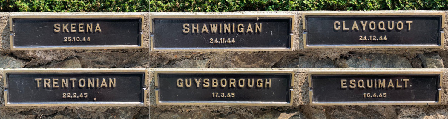
SKEENA
25.10.44
[plaque]
SHAWINIGAN
24.11.44
[plaque]
CLAYOQUOT
24.12.44
[plaque]
TRENTONIAN
22.2.45
[plaque]
GUYSBOROUGH
17.3.45
[plaque]
ESQUIMALT
16.4.45
Street View
Location
Esquimalt Sailors' Walk
Opposite 1229 Esquimalt Road
Esquimalt
British Columbia
Esquimalt Sailors' Walk
Opposite 1229 Esquimalt Road
Esquimalt
British Columbia
GPS Coordinates
Lat. 48.4302099
Long. -123.413118
Lat. 48.4302099
Long. -123.413118