British Columbia

Province Code
BC
City/Municipality
Comox
Memorial Number
59028-019
Type
Location
19 Wing Comox
in Canada
Yes
GPS Coordinates
49.710696, -124.9089804
Inscription

(needs further research/recherche incomplète)

Image
Province
!4v1622728799799!6m8!1m7!1s-aAOk2_TTNDIun-X_nZGEg!2m2!1d49.71069595493893!2d-124.9089804350415!3f229.77787758017962!4f5.318534721306705!5f1.591282581749823
Body Content

The 19 Wing Comox Permanent Married Quarters, the military housing for members and their families, were called "Wallace Gardens." The neighbourhood was named in honour of Clarence Wallace CBE OD, who had been a Lieutenant Governor of British Columbia. Born in Vancouver, he fought in World War I and was wounded at Ypres, and would build ships for the war during World War II. He had four sons in the RCAF during World War II: one killed in the Battle of Britain, two shot down on operations and who returned home, and one who completed his service unharmed.


City
Comox
Country
Type Description
Neighbourhood
Memorial CF Legacy ID
4352
City/Municipality
Alert Bay
Memorial Number
59028-017
Type
Address
103 Front Street
Location
Christ Church
in Canada
Yes
GPS Coordinates
50.5917526, -126.9331437
Inscription

[plaque]

TO THE GLORY OF GOD
and in Loving Memory of 

Edwin Victor Cook, D.C.M Killed in Action, August 28, 1918

Edwin Victor Cook, Killed in Action, September 30, 1944

"Greater love hath no man than this, that he lay down his life for his friends."

Image
Caption
plaque
1 of 2 images
Image
Caption
plaque
1 of 2 images
War or Conflict Term
Province
!4v1622662349423!6m8!1m7!1szv5GZqNYioS6ScX9-hbXQw!2m2!1d50.59175260762025!2d-126.9331437359678!3f43.59781929268421!4f6.953190412065695!5f1.550524464697201
Body Content

The Cook Plaque is dedicated to Edwin Victor Cook who died while serving in the First World War and Edwin Victor Cook who died while serving in the Second World War.

The Alert Bay Roll of Honour is also located in the church.

City
Alert Bay
Country
Type Description
Bronze plaque
Memorial CF Legacy ID
3257
City/Municipality
Comox
Memorial Number
59028-016
Type
Address
1729 Comox Avenue
Location
Comox Archives and Museum
in Canada
Yes
GPS Coordinates
49.6727989, -124.9243125
Inscription

needs further research/recherche incomplète

Image
Photo Credit
Comox Archives and Museum Society
Caption
Roll of Honour
War or Conflict Term
Province
!4v1622809936677!6m8!1m7!1sguZRKLoFesxuOaeiQDVYLw!2m2!1d49.6727989333091!2d-124.9243124686112!3f193.87921522215436!4f0.5491011233112886!5f1.8216448713766366
Body Content

The Lazo District Second World War Roll of Honour was erected by the Lazo Women's Institute. When the Lazo Women's Institute Hall on Knight Road was closed, the Roll of Honour was moved to the Comox Archives and Museum.

City
Comox
Country
Type Description
Roll of Honour
Memorial CF Legacy ID
5119
City/Municipality
Tahsis
Memorial Number
59028-015
Type
Location
South end of South Maquinna Drive
in Canada
Yes
GPS Coordinates
49.9101677, -126.6656175
Inscription

(no inscription/pas d'inscription)

Image
Photo Credit
Paul Edgington
Caption
front view
1 of 3 images
Image
Photo Credit
Lauren Roth
Caption
Surroundings - Remembrance Day 2020
1 of 3 images
Image
Photo Credit
Lauren Roth
Caption
Cross - Remembrance Day 2020
1 of 3 images
Province
Body Content

Monument in the Village of Tahsis, British Columbia constructed in memory of all war veterans.

City
Tahsis
Country
Type Description
Cross
Memorial CF Legacy ID
4202
City/Municipality
Heriot Bay
Memorial Number
59028-013
Type
Address
1503 West Road
Location
Royal Canadian Legion Branch #154
in Canada
Yes
GPS Coordinates
50.1007826, -125.2093166
Inscription

[top plaque/plaque du haut]

LEST WE FORGET
WORLD WAR I 1914 - 1918
WORLD WAR II 1939 - 1945
KOREA 1950-1953

[bottom plaque/plaque en bas]
This Cenotaph Is Dedicated To
All The Men And Women
Who Gave Their Lives In All Wars.
The Freedom We Enjoy Today
Is Due To Their Sacrifices.

Image
Photo Credit
Barb McDonald
Caption
front view
Province
!4v1622658050276!6m8!1m7!1s_w9vl75CcABlWJP_mIY4gQ!2m2!1d50.10078255285155!2d-125.2093166299598!3f100.09544366846589!4f2.23417500160258!5f1.752299069536544
Body Content

Needs further research

City
Heriot Bay
Country
Type Description
Cairn
Memorial CF Legacy ID
7698
City/Municipality
Port Hardy
Memorial Number
59028-012
Type
Address
7368 Market Street
Location
Carrot Park
in Canada
Yes
GPS Coordinates
50.7244364, -127.4922617
Inscription

[plaque]
IN MEMORY OF
THOSE WHO LAID DOWN THEIR LIVES
FOR THEIR COUNTRY

[plaque]
WORLD WAR
I
1914 - 1918

[plaque]
WORLD WAR
II
1939 - 1945

[plaque]
KOREA
1950 - 1953

Image
Photo Credit
101 Squadron (North Island)
Caption
new cenotaph
1 of 3 images
Image
Photo Credit
District of Port Hardy
Caption
slab with cross
1 of 3 images
Image
Photo Credit
District of Port Hardy
Caption
old cenotaph
1 of 3 images
Province
!4v1622656692263!6m8!1m7!1sDTy34NjQmey7ObxE0zMBqA!2m2!1d50.72443644091851!2d-127.4922617365752!3f104.47851521539812!4f-1.6718833540502657!5f2.448758175096836
Body Content

The original Port Hardy Cenotaph at Carrot Park was built in 1982 by a group of local Veterans. By the year 2000, cracks in the mortar caused pieces to fall out. Soon pieces of rock fell out, the plaques loosened and the cross bent, showing signs of corrosion. The damage was due to years of the park being flooded and strong winds blowing salt water onto the cenotaph. 

The Port Hardy and First Nations Cenotaph/Memorial Committee was formed and restoration work began on August 6, 2016. Funding was provided from the Cenotaph Restoration Program (District and Federal government), Port Hardy Royal Canadian Legion, 101 squadron, and Port Hardy Rotary Club. The cenotaph was rebuilt, using all of the facial parts from the old one, and erected on a new foundation. The cross was installed on its own foundation placed in the center of the cenotaph and the Memorial Pole. The refurbished flag poles were also moved to their new location. The new Port Hardy Cenotaph was officially unveiled on November 11, 2016.

The Memorial Pole was also restored and erected on a foundation to the left of the cross.

City
Port Hardy
Country
Type Description
Obelisk, slab
Memorial CF Legacy ID
1309
City/Municipality
Port McNeill
Memorial Number
59028-010
Type
Address
McNeill Road and Campbell Way
Location
Rotary Park
in Canada
Yes
GPS Coordinates
50.5833393, -127.0784277
Inscription

[plaque/plaque]

LEST WE FORGET

1914-18
1939-45
1950-53

Image
Photo Credit
Margaret Page; Sue Harvey
Caption
cairn (front)
1 of 4 images
Image
Caption
front and side view
1 of 4 images
Image
Caption
details
1 of 4 images
Image
Caption
back
1 of 4 images
Province
!4v1622655481515!6m8!1m7!1sDCFk5KkQrlvNC8V4-tR9dw!2m2!1d50.58333933140065!2d-127.0784276860227!3f293.96829525808954!4f-4.9259925233358075!5f3.2106857208649746
Body Content

Constructed by Mr. Robert Bowes, in 1985, a war veteran and member of the local Royal Canadian Legion Branch, this memorial is dedicated to the memory of the First and Second World Wars and the Korean War. Flag poles, stepstones and benches have been added to the area over the years. The Public Works department of the Town of Port McNeill care for the area the memorial.

City
Port McNeill
Country
Type Description
Fieldstone cairn
Memorial CF Legacy ID
1310
City/Municipality
Courtenay
Memorial Number
59028-009
Type
Address
400 Cliffe Avenue
Location
Jubilee Square
in Canada
Yes
GPS Coordinates
49.6922908, -124.9976589
Inscription

LEST WE FORGET
OUR FALLEN COMRADES
ERECTED BY
BRANCH #17
ROYAL
CANADIAN
LEGION
IN MEMORY OF
THOSE WHO
LOST THEIR LIVES
IN CANADA'S WARS
AND UNITED NATIONS
PEACE KEEPING
DUTIES

Image
Photo Credit
Marjorie Chester; Marguerite Holgate; Steve White
Caption
front view
1 of 4 images
Image
Caption
plaque
1 of 4 images
Image
Caption
side view
1 of 4 images
Image
Caption
surroundings
1 of 4 images
Province
!4v1622655262124!6m8!1m7!1s5KlfYUulMhzaq32tq0cw8Q!2m2!1d49.69229081340173!2d-124.997658862047!3f86.31484903113994!4f-2.809902581451638!5f1.881514338020993
Body Content

Constructed in 1996 in Memory of fallen comrades of the First and Second World Wars. Erected and paid for by Branch 17, Royal Canadian Legion of Courtenay. The work was done by the City of Courtenay. Inauguration Ceremony conducted July 1, 1997 by Reverend Ray Brandon, Legion Padre. Other dignitaries included Legion president Roche St. Pierre and city council member Doug Bell.

City
Courtenay
Country
Type Description
Cairn (Field stone and masonry base on cement foundation)
Memorial CF Legacy ID
4784
City/Municipality
Port Hardy
Memorial Number
59028-008
Type
Location
Northeast of Bear Cove
in Canada
Yes
GPS Coordinates
50.7292, -127.4455
Inscription

[front/devant]

DAKOTA 576
CRASHED 19TH APRIL, 1944
P.O. J.M. TALBOT, PILOT - KIFA
P.O. T.S. WORDLOW, PILOT - KIFA
SGT. T.R. MOSS, W.A.G. - SURVIVED
WHILE ON A NAVIGATION EXERCISE
FROM R.A.F. 32 O.T.U. PAT BAY, B.C. THE
AIRCRAFT OVERSHOT PORT HARDY AIRPORT
AND RAN OUT OF FUEL.
REQIESCAT EN APCE FRATRES
101 R.C.A.F. (NORTH ISLAND) SQUADRON,
AUGUST 2001

Image
Photo Credit
Russ Hellberg
Caption
Front
1 of 6 images
Image
Photo Credit
Russ Hellberg
Caption
Plaque
1 of 6 images
Image
Photo Credit
Russ Hellberg
Caption
Crash
1 of 6 images
Image
Photo Credit
Russ Hellberg
Caption
Lt Gov Iona Campagnola dedicates the memorial to the crew of RAF Dak 576
1 of 6 images
Image
Photo Credit
Russ Hellberg
Caption
MLA Rod Visser places a wreath
1 of 6 images
Image
Photo Credit
Russ Hellberg
Caption
West Coast Helicopter which took the Dedicating Party in and out.
1 of 6 images
War or Conflict Term
Province
Body Content

On 19 April 1944, Dakota 576 crashed into a rock killing two of the crewmen, Pilot Officer J.M. Talbot and Pilot Officer T.S. Wordlow. The wireless air gunner, Sgt. T.R. Moss was found the next day in shock but survived.

City
Port Hardy
Country
Type Description
Obelisk
Memorial CF Legacy ID
7430
City/Municipality
Cumberland
Memorial Number
59028-005
Type
Address
2770 Dunsmuir Avenue
Location
Royal Canadian Legion Branch 28
in Canada
Yes
GPS Coordinates
49.6193486, -125.0252288
Inscription

needs further research/recherche incomplète

Image
Photo Credit
Colin Barr; Leonard Frank
Caption
Memorial Arch
1 of 4 images
Caption
Memorial Hall and Arch 1921-22
1 of 4 images
Image
Caption
Left arch
1 of 4 images
Image
Caption
Right arch
1 of 4 images
Province
!4v1622640857104!6m8!1m7!1sn05UHYA65agMx9YrUzNvsw!2m2!1d49.61934863333578!2d-125.0252287788289!3f338.70748512770234!4f1.6944501719443252!5f1.843985177367324
Body Content

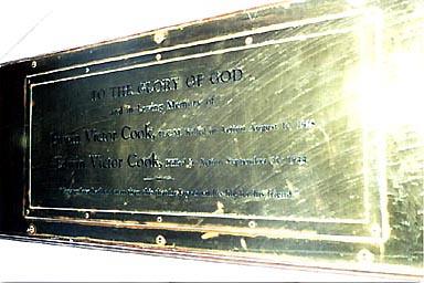
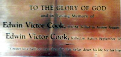
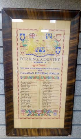
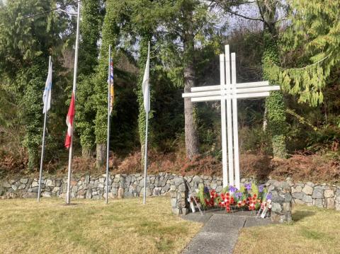
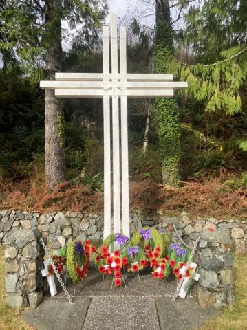
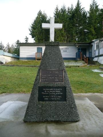
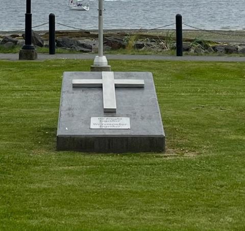
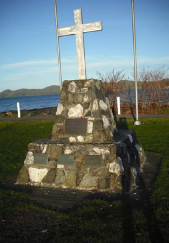
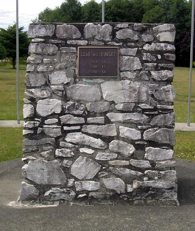
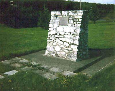
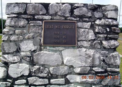
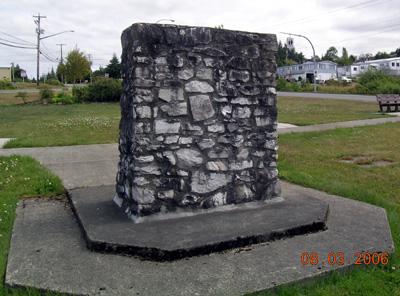
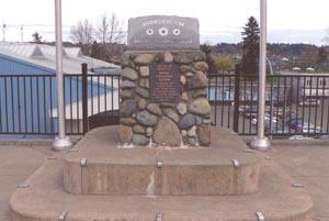
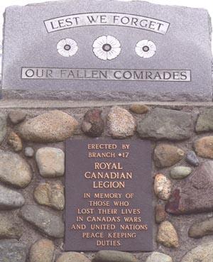
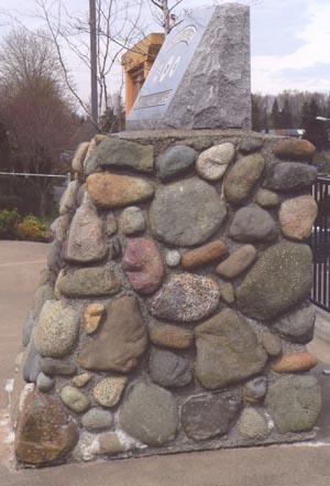
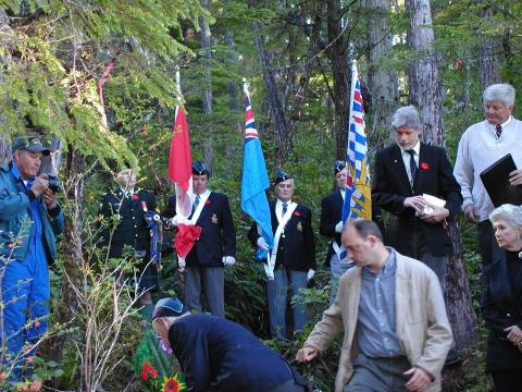
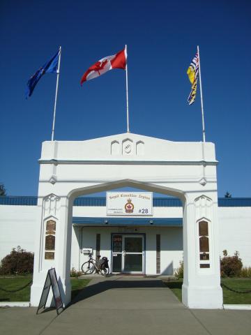
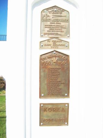
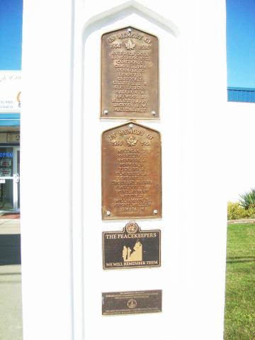
[Excerpt from Cumberland heritage: A selected history of people, buildings, institutions and sites, 1918 -1950. by Jennifer Nell Bar; Corporation of the City of Cumberland,p129-131] In 1997, the Town of Cumberland made the arch and the front 14 bollards and chain a historic site. Later that year, the Canadian Scots Regiment from Victoria, British Columbia, placed a tablet in memory of local men and women who served with the Canadian Scots. On 11 November 1918, the day Armistice was signed in France to end the First World War, Cumberland was in the middle of the Spanish Influenza epidemic. All public places were closed by order of city council. However, at two o'clock in the morning, the church bells and fire bell began ringing, and the whistles of the locomotives in the WCR round house began blowing. The phones rang throughout town, the city lit up and, by five o'clock, the citizens of Cumberland were celebrating in the streets and decorating Dunsmuir Avenue. On the first anniversary of Armistice Day in 1919, the citizens celebrated with a masquerade ball, which was hailed as the "first annual". Although the balls continued for several years on another day, it was felt that it would be more fitting to commemorate 11 November with a memorial ceremony to the dead rather than with a celebration. In 1919, the city showed its appreciation to the men who had gone overseas to fight by giving a lot to GWVA so they could build a Memorial Hall. The hall, designed by William Arthur Owen and built by H. Trehearne of Courtenay, was officially opened in October 1920. A dance hall, added in March 1922, was used by many organizations for banquets and formal functions. In 1921, the GWVA built a Memorial Arch in front of the Hall. On this Arch, they placed tablets with the names of 28 local people, including two Japanese-Canadians, who lost their lives in the service of their country during the First World War. This Arch was also designed by Owen, and the bronze tablets were manufactured by Henry Birks and Sons, Montreal. Following the Second World War, the names of the 15 locals who died in that conflict were placed on the Arch, as was a later plaque honouring all local Korean War veterans. Those who died have a maple leaf beside their names. The Tudor-arch shape of the main structure of the Memorial Arch is echoed in three inset panels at the top and long panels down the front sides. The Arch, in turn, echoed the front entrance and window shapes on the Memorial Hall. The original roughcast stucco gave much more definition to the recessed forms than the modern flat-coloured stucco. The poured concrete bollards linked with heavy chains which outline the property are contemporary with the arch, although the ground level around them had risen. The GWVA became the Royal Canadian Legion of the British Empire Service League in 1926, and Cumberland Branch was instituted as No.28. When the original Memorial Hall was gutted by fire on 17 April 1962, it was replaced by a smaller, one-story concrete block building.

City
Cumberland
Country
Type Description
Memorial Arch and Hall
Memorial CF Legacy ID
4785