Erected by the municipalities of Armstrong and Spallumcheen, this memorial park is dedicated to local veterans. It contains several other memorials, including a signboard display with badges and flagpoles, two shafts (one dedicated to the men of the First World War and the other to those of the Second World War), “Stones of Sacrifice” with an explanatory plaque. Refer to the following memorial numbers: Shaft dedicated to the men of the First World War: 59014-013 Signboard dedicated to the men of the Second World War: 59014-004 Stones of Sacrifice: 59014-019
Memorial Park
City/Municipality
Armstrong
Memorial Number
59014-003
Type
Address
3285 Pleasant Valley Road
Location
Memorial Park
in Canada
Yes
GPS Coordinates
50.445577, -119.2003616
Submitted By
Shelly Thibodeau
Inscription
[sign/enseigne]
MEMORIAL PARK
Image
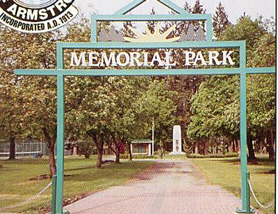
Photo Credit
unknown
Caption
Entrance to park. Display dedicated to the men of the Second World War and Shaft dedicated to the men of the First World War visible in background
Province
!4v1620665209729!6m8!1m7!1speremnTa3mK8LrKnzTY5Sw!2m2!1d50.44557697556507!2d-119.2003615642017!3f275.2235705357058!4f0.3959486793670095!5f0.7820865974627469
Body Content
City
Armstrong
Country
Display photo gallery on sidebar
Off
Type Description
Park
Memorial CF Legacy ID
69