British Columbia

Province Code
BC
City/Municipality
New Westminster
Memorial Number
59013-017
Type
Address
Miner Street
in Canada
Yes
GPS Coordinates
49.2204882, -122.8958924
Inscription

Province
!4v1620323375794!6m8!1m7!1sl0W88x94mycxIVqNeDt5Aw!2m2!1d49.22048820651745!2d-122.8958924458303!3f178.11207143481508!4f2.557730781257675!5f1.7433643785928363
Body Content

This street was named for the sappers and miners of the Royal Engineers.

City
New Westminster
Country
Type Description
Street
Memorial CF Legacy ID
7750
City/Municipality
New Westminster
Memorial Number
59013-016
Type
Address
Elliot Street
in Canada
Yes
GPS Coordinates
49.2081277, -122.903711
Inscription

Province
!4v1620322049789!6m8!1m7!1sk4JwB3fqiDJdusZdilmQNg!2m2!1d49.20812770857551!2d-122.9037110480167!3f171.40453581665127!4f-1.5811439598104897!5f0.6990773750880548
Body Content

This street was named for Lt G.H. Elliot from the Royal Marines on station 1857 - 1860.

City
New Westminster
Country
Type Description
Street
Memorial CF Legacy ID
7749
City/Municipality
New Westminster
Memorial Number
59013-015
Type
Address
East Columbia Street
in Canada
Yes
GPS Coordinates
49.2165166, -122.8939358
Inscription

Province
!4v1620321538963!6m8!1m7!1sfo85ZSzsZn-CKl8nAt6PKw!2m2!1d49.21651657847195!2d-122.8939358141276!3f15.569938334561621!4f9.092353525372544!5f0.8360404958313108
Body Content

This street was named by the Royal Engineers, Columbia Detachment after coming to British Columbia.

City
New Westminster
Country
Type Description
Street
Memorial CF Legacy ID
7748
City/Municipality
New Westminster
Memorial Number
59013-014
Type
Address
Columbia Street
in Canada
Yes
GPS Coordinates
49.2046419, -122.905416
Inscription

Province
!4v1620320979765!6m8!1m7!1scUSuyQGAvtodJZzPZKngFA!2m2!1d49.20464193687246!2d-122.9054160415853!3f255.93911210310847!4f5.245468757315734!5f0.7820865974627469
Body Content

This street was named by the Royal Engineers, Columbia Detachment after coming to British Columbia.

City
New Westminster
Country
Type Description
Street
Memorial CF Legacy ID
7747
City/Municipality
New Westminster
Memorial Number
59013-013
Type
Location
In the block surrounded by 3rd Street, 4th Street, Royal Ave, and Queens Ave
in Canada
Yes
GPS Coordinates
49.2086215, -122.9099235
Image
Province
!4v1620319896893!6m8!1m7!1sAtnFvav7gpgxecyt1ytMEw!2m2!1d49.20862152605775!2d-122.9099235455388!3f127.36634511142846!4f9.430708285354612!5f0.7820865974627469
Body Content

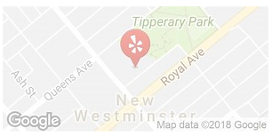
Tipperary Park, identified in 1859 to 1863, along with many other areas in the City, was identified by the Columbia Detachment of Royal Engineers, as park and government reserves. The residents in the vicinity of the reserve named the camp ‘New Tipperary’ from the fact that a few immigrants from the ‘ould dart’ were among its inhabitants. Tipperary Park was originally one of three government reserves upon which Colonel Moody and the Royal Engineers planned to build the government buildings for the capital city of the Colony of British Columbia. These sites were laid out in the extension to the original city above Royal Avenue in 1862. The central square (now city hall and Friendship Gardens) was flanked by two minor squares; the western square located across Sixth Street became home to the city’s first public school, and the eastern square - now Tipperary Park - was always used as a park square. Tipperary Park was formally conveyed to the city’s ownership from the province in 1908, and vested forever in trust “for the recreation and enjoyment of the public.” Tipperary Park was developed in 1911 following landscape architect G.L.K. MacLean’s vision. Today it offers a quiet place with picnic tables, benches, pathways, and is the home of the New Westminster Tennis Club. The area of Friendship Garden was also once known as a part of Tipperary Park. Tipperary Park, established in 1963, is 3.79 acres, offers visitors with tranquillity, monuments, public art and unique ponds. The Peace Marker is a memorial for Peace in four languages English, French, Spanish, Chinese. There are a number of commemorative trees throughout the park.

In 1962, the Friendship Park area was a forested grove behind City Hall. That year a typhoon blew through the area and uprooted many large trees leaving huge holes where their roots had been torn up. A member of the Parks and Recretion Department's gardening staff knew and loved Japanese water gardens, and so the holes on the newly damaged landscape, gently sloping across the property, were redeveloped into a beautiful garden. The Friendship Gardens were built in 1963 as a tribute to New Westminster's sister city - Moriguchi, Japan. This area is now a favourite place for those seeking quiet contemplation and picturesque views, and for those looking for a special place for wedding photos.

City
New Westminster
Country
Type Description
Park
Memorial CF Legacy ID
7739
City/Municipality
New Westminster
Memorial Number
59013-012
Type
Address
511 Royal Avenue
Location
Inside New Westminster City Hall
in Canada
Yes
GPS Coordinates
49.206593, -122.9107128
Province
!4v1620315541036!6m8!1m7!1su1qYWHS3VGCGDuQhI4HUfw!2m2!1d49.20659303431047!2d-122.9107127746818!3f311.83186793548373!4f10.484088235786401!5f0.7820865974627469
Body Content

This plaque represents the coat of arms of the Royal Engineers who founded and surveyed the city from 1859 - 1863.

City
New Westminster
Country
Type Description
Plaque
Memorial CF Legacy ID
7738
City/Municipality
New Westminster
Memorial Number
59013-011
Type
Address
530 Queens Avenue
Location
The Royal Westminister Regiment
in Canada
Yes
GPS Coordinates
49.2068457, -122.9124514
Inscription

 (needs further research/recherche incomplete)


Image
Photo Credit
https://commons.wikimedia.org/wiki/File:Victoria_Cross_Cairn.jpg
Province
!4v1620314037366!6m8!1m7!1s4_Mf2xkcsozOn_r1zbbsGw!2m2!1d49.20684568889561!2d-122.9124514244571!3f46.62847635336781!4f-2.3127149296782647!5f2.1499331155316015
Body Content

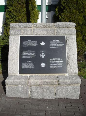
This commemorative trilingual (English, French, Ukranian) marker notes the two Victoria Cross winners who served with the Regiment or an antecedent group: Jack Mahony (Westminster Regiment) and Filip Konowal (47th Canadian Infantry Battalion).

City
New Westminster
Country
Type Description
Monument
Memorial CF Legacy ID
7743
City/Municipality
New Westminster
Memorial Number
59013-010
Type
Address
530 Queens Avenue
Location
Corner of 6th Street and Queens Avenue
in Canada
Yes
GPS Coordinates
49.2070761, -122.9127286
Inscription

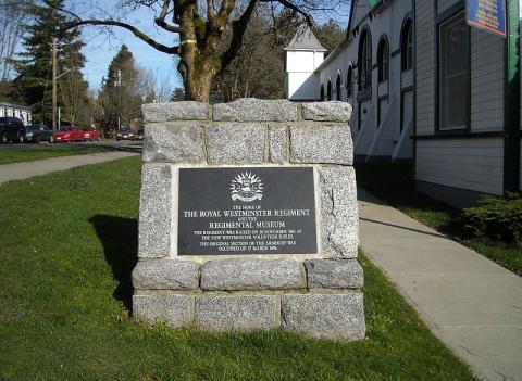
THE HOME OF

THE ROYAL WESTMINSTER REGIMENT

AND THE

REGIMENTAL MUSEUM

THE REGIMENT WAS RAISED ON 20 NOVEMBER 1863 AS

THE NEW WESTMINSTER VOLUNTEER RIFLES.

THE ORIGINAL SECTION OF THE ARMOURY WAS

OCCUPIED ON 27 MARCH 1896.

Image
Photo Credit
https://commons.wikimedia.org/wiki/File:R_Westmr_R_Cairn.jpg
Province
!4v1620312960486!6m8!1m7!1sHEqkrF_JXqBf99u9_4IwRw!2m2!1d49.2070761159701!2d-122.9127285864499!3f74.87784958228253!4f-4.893437308667245!5f1.8489325452144922
Body Content

This monument identifies the home of the Royal Westminster Regiment and the Regimental Museum.

City
New Westminster
Country
Type Description
Monument
Memorial CF Legacy ID
7742
City/Municipality
New Westminster
Memorial Number
59013-009
Type
Address
530 Queens Avenue
Location
The Royal Westminster Regiment
in Canada
Yes
GPS Coordinates
49.2073679, -122.9123281
Image
Photo Credit
Victoria Edwards / nwheritage.org
Province
!4v1620311812858!6m8!1m7!1st0FqiKI4aZ4qxLj0302vOg!2m2!1d49.20736785909519!2d-122.9123281225001!3f163.34384344828265!4f0.1427475891464951!5f1.243259148496517
Body Content

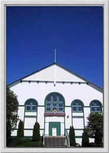
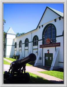
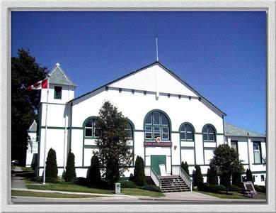
Opened in 1896, the Armoury has served military and community needs, in war and in peace, throughout its life. The home of the Royal Westminster Regiment, the Armoury has been the site of such varied events as early city basketball games, vegetable exhibitions, a dinner for Winston Churchill, gala celebrations, and an emergency supply centre after the City's Great Fire of 1898. Its military obligations encompass conflicts from the Boer War to the present including peacekeeping throughout the world.

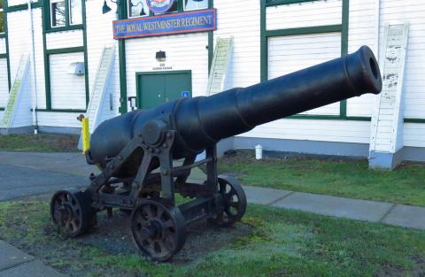
This sixty-four pounder muzzle-loader was once mounted in the Gun Room of the Armoury to be used in the defence of the City. It is a Sea-Service weapon from the lower gundeck of a line-of-battleship. For Land-Service, apart from static use in a fort, it would need a very heavy wheeled carriage for mobility.

City
New Westminster
Country
Type Description
Cannon
Memorial CF Legacy ID
7741
City/Municipality
New Westminster
Memorial Number
59013-008
Type
Address
530 Queens Avenue
Location
The Royal Westminster Regiment
in Canada
Yes
GPS Coordinates
49.2073679, -122.9123281
Image
Photo Credit
Victoria Edwards/ nwheritage.org
Caption
New Westminster Armoury
1 of 3 images
Image
Photo Credit
Victoria Edwards/ nwheritage.org
Caption
New Westminster Armoury
1 of 3 images
Image
Photo Credit
Victoria Edwards/ nwheritage.org
Caption
New Westminster Armoury
1 of 3 images
Province
!4v1620310650036!6m8!1m7!1st0FqiKI4aZ4qxLj0302vOg!2m2!1d49.20736785909519!2d-122.9123281225001!3f141.6196694808061!4f8.772306054431183!5f0.6559011455329636
Body Content

This remarkably resilient wooden building is referred to as "The Armouries" by members of the Royal Westminster Regiment. The Armoury proudly served as the headquarters for the Regiment through the first and second World Wars and continues to do so today. In addition, the building houses the Regimental Museum. In 1895 contractor David Bain, using plans drawn up by Dominion Government Engineer F.C. Gamble, began work on this building. The building was completed in 1896 but the finishing touch was the construction of the Gun Room in 1898. The building's Richardsonian Romanesque architectural style is thought to be based on the Philadelphia Centennial Exposition Building of 1876. The founding of the Regiment dates back to 1863. During the Second World War the men of the Westminster Regiment saw more combat than any other Canadian fighting unit. In recognition of outstanding service Queen Elizabeth bestowed the title "Royal" upon the Regiment in 1966.

City
New Westminster
Country
Type Description
Building - armoury
Memorial CF Legacy ID
7740