British Columbia

Province Code
BC
City/Municipality
New Westminster
Memorial Number
59013-022
Type
Address
Cumberland Street and East Columbia Street
Location
Sapperton Landing Park
in Canada
Yes
GPS Coordinates
49.2204713, -122.8924513
Inscription

Province
!4v1620327317532!6m8!1m7!1sezirWm270v43Nr1oHQwhIQ!2m2!1d49.22047134802785!2d-122.8924513184186!3f110.76964225953651!4f-5.2317434195761905!5f1.8177833267004715
Body Content

This park was named in honour of the Sappers of the Columbia Detachment of Royal Engineers. The park was constructed in 2001.

City
New Westminster
Country
Type Description
Park
Memorial CF Legacy ID
7755
City/Municipality
New Westminster
Memorial Number
59013-021
Type
Address
Smokey Smith Place
in Canada
Yes
GPS Coordinates
49.2194449, -122.9107966
Inscription

Province
!4v1620326190449!6m8!1m7!1sYUqxPaiSZ3bXAhKSJQ1J8A!2m2!1d49.2194449091087!2d-122.9107965543676!3f61.347751399170875!4f1.3400616087066055!5f0.7820865974627469
Body Content

This street was named in honour of Pte. Ernest Alvia "Smokey" Smith, VC.

City
New Westminster
Country
Type Description
Street
Memorial CF Legacy ID
7754
City/Municipality
New Westminster
Memorial Number
59013-020
Type
Address
Jack Mahony Place
in Canada
Yes
GPS Coordinates
49.2201387, -122.9114779
Province
!4v1620325631909!6m8!1m7!1slo4LyOvJgidRfNlpv0lLdg!2m2!1d49.22013870147604!2d-122.9114779425654!3f37.42766881658054!4f0.8717202608441426!5f0.7820865974627469
Body Content

This street was named in honour of Major John Keefer Mahony, VC.

City
New Westminster
Country
Type Description
Street
Memorial CF Legacy ID
7753
City/Municipality
New Westminster
Memorial Number
59013-019
Type
Address
Sapper Street
in Canada
Yes
GPS Coordinates
49.2204889, -122.8945729
Inscription

Province
!4v1620325062364!6m8!1m7!1s8eDoqqnOJJZMU8yRxaCNkA!2m2!1d49.22048885964671!2d-122.8945728684609!3f356.17477255826804!4f2.418320870216135!5f1.4695573975420268
Body Content

This street was named for the Royal Engineers or "Sappers".

City
New Westminster
Country
Type Description
Street
Memorial CF Legacy ID
7752
City/Municipality
New Westminster
Memorial Number
59013-018
Type
Address
Moody Street
in Canada
Yes
GPS Coordinates
49.2020907, -122.9162344
Inscription

Province
!4v1620324209640!6m8!1m7!1s-5IiRFwcCnYBORJHS5JLWg!2m2!1d49.20209066109535!2d-122.9162343777471!3f51.0345763781585!4f15.005881597575069!5f0.5474543880784044
Body Content

This street was named for Col Richard Clement Moody, the founder of New Westminster.

City
New Westminster
Country
Type Description
Street
Memorial CF Legacy ID
7751
City/Municipality
New Westminster
Memorial Number
59013-017
Type
Address
Miner Street
in Canada
Yes
GPS Coordinates
49.2204882, -122.8958924
Inscription

Province
!4v1620323375794!6m8!1m7!1sl0W88x94mycxIVqNeDt5Aw!2m2!1d49.22048820651745!2d-122.8958924458303!3f178.11207143481508!4f2.557730781257675!5f1.7433643785928363
Body Content

This street was named for the sappers and miners of the Royal Engineers.

City
New Westminster
Country
Type Description
Street
Memorial CF Legacy ID
7750
City/Municipality
New Westminster
Memorial Number
59013-016
Type
Address
Elliot Street
in Canada
Yes
GPS Coordinates
49.2081277, -122.903711
Inscription

Province
!4v1620322049789!6m8!1m7!1sk4JwB3fqiDJdusZdilmQNg!2m2!1d49.20812770857551!2d-122.9037110480167!3f171.40453581665127!4f-1.5811439598104897!5f0.6990773750880548
Body Content

This street was named for Lt G.H. Elliot from the Royal Marines on station 1857 - 1860.

City
New Westminster
Country
Type Description
Street
Memorial CF Legacy ID
7749
City/Municipality
New Westminster
Memorial Number
59013-015
Type
Address
East Columbia Street
in Canada
Yes
GPS Coordinates
49.2165166, -122.8939358
Inscription

Province
!4v1620321538963!6m8!1m7!1sfo85ZSzsZn-CKl8nAt6PKw!2m2!1d49.21651657847195!2d-122.8939358141276!3f15.569938334561621!4f9.092353525372544!5f0.8360404958313108
Body Content

This street was named by the Royal Engineers, Columbia Detachment after coming to British Columbia.

City
New Westminster
Country
Type Description
Street
Memorial CF Legacy ID
7748
City/Municipality
New Westminster
Memorial Number
59013-014
Type
Address
Columbia Street
in Canada
Yes
GPS Coordinates
49.2046419, -122.905416
Inscription

Province
!4v1620320979765!6m8!1m7!1scUSuyQGAvtodJZzPZKngFA!2m2!1d49.20464193687246!2d-122.9054160415853!3f255.93911210310847!4f5.245468757315734!5f0.7820865974627469
Body Content

This street was named by the Royal Engineers, Columbia Detachment after coming to British Columbia.

City
New Westminster
Country
Type Description
Street
Memorial CF Legacy ID
7747
City/Municipality
New Westminster
Memorial Number
59013-013
Type
Location
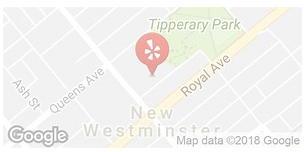
In the block surrounded by 3rd Street, 4th Street, Royal Ave, and Queens Ave
in Canada
Yes
GPS Coordinates
49.2086215, -122.9099235
Image
Province
!4v1620319896893!6m8!1m7!1sAtnFvav7gpgxecyt1ytMEw!2m2!1d49.20862152605775!2d-122.9099235455388!3f127.36634511142846!4f9.430708285354612!5f0.7820865974627469
Body Content

Tipperary Park, identified in 1859 to 1863, along with many other areas in the City, was identified by the Columbia Detachment of Royal Engineers, as park and government reserves. The residents in the vicinity of the reserve named the camp ‘New Tipperary’ from the fact that a few immigrants from the ‘ould dart’ were among its inhabitants. Tipperary Park was originally one of three government reserves upon which Colonel Moody and the Royal Engineers planned to build the government buildings for the capital city of the Colony of British Columbia. These sites were laid out in the extension to the original city above Royal Avenue in 1862. The central square (now city hall and Friendship Gardens) was flanked by two minor squares; the western square located across Sixth Street became home to the city’s first public school, and the eastern square - now Tipperary Park - was always used as a park square. Tipperary Park was formally conveyed to the city’s ownership from the province in 1908, and vested forever in trust “for the recreation and enjoyment of the public.” Tipperary Park was developed in 1911 following landscape architect G.L.K. MacLean’s vision. Today it offers a quiet place with picnic tables, benches, pathways, and is the home of the New Westminster Tennis Club. The area of Friendship Garden was also once known as a part of Tipperary Park. Tipperary Park, established in 1963, is 3.79 acres, offers visitors with tranquillity, monuments, public art and unique ponds. The Peace Marker is a memorial for Peace in four languages English, French, Spanish, Chinese. There are a number of commemorative trees throughout the park.

In 1962, the Friendship Park area was a forested grove behind City Hall. That year a typhoon blew through the area and uprooted many large trees leaving huge holes where their roots had been torn up. A member of the Parks and Recretion Department's gardening staff knew and loved Japanese water gardens, and so the holes on the newly damaged landscape, gently sloping across the property, were redeveloped into a beautiful garden. The Friendship Gardens were built in 1963 as a tribute to New Westminster's sister city - Moriguchi, Japan. This area is now a favourite place for those seeking quiet contemplation and picturesque views, and for those looking for a special place for wedding photos.

City
New Westminster
Country
Type Description
Park
Memorial CF Legacy ID
7739