British Columbia

Province Code
BC
City/Municipality
Chilliwack
Memorial Number
59006-060
Type
Address
Calais Crescent
Location
Vedder Crossing
in Canada
Yes
GPS Coordinates
49.1013959, -121.9697614
Inscription

needs further research/recherche incomplète

War or Conflict Term
Province
!4v1719231576038!6m8!1m7!1snHtu7iy4LsMoa_0ecIv_Kw!2m2!1d49.10139589821814!2d-121.9697614125486!3f213.8261284578218!4f-11.982409136913773!5f2.0945507790889035
Body Content

On September 6, 1944, the 2nd Canadian Infantry Division marched eastward with the objective of clearing the entire coastal area east of Calais. Le Havre, Boulogne and Calais were taken by the 3rd Canadian Infantry Division only after massive attacks with combined air and ground assaults. This street was named in September 2006 to commemorate those who fought at Calais.

City
Chilliwack
Country
Type Description
Street
Memorial CF Legacy ID
12606
City/Municipality
Chilliwack
Memorial Number
59006-059
Type
Address
Festubert Road
Location
Vedder Crossing
in Canada
Yes
GPS Coordinates
49.0992182, -121.974378
Inscription

needs further research/recherche incomplète

War or Conflict Term
Province
!4v1719231216603!6m8!1m7!1sh7GVYB1EQvfk254A2bY_7w!2m2!1d49.09921824003737!2d-121.9743780162196!3f7.74637888823073!4f-17.776577877473187!5f0.7820865974627469
Body Content

This boulevard is named in honour of those who fought at the Battle of Festubert, the second major engagement fought by Canadian troops in the First World War. 

City
Chilliwack
Country
Type Description
Street
Memorial CF Legacy ID
12605
City/Municipality
Chilliwack
Memorial Number
59006-058
Type
Address
Keith Wilson Road and Vedder Road
Location
Garrison Crossing
in Canada
Yes
GPS Coordinates
49.1041469, -121.9624916
Inscription

GARRISON CROSSING

Vedder Crossing

Vedder Crossing was a quiet community with only a few farm
homes and lumber industry related businesses before Camp
Chilliwack was established in 1942. That changed when the
Second World War brought 1200 soldiers to the site to construct
the training camp. Several existing businesses profited from
the military presence and after the war, the training base
continued its function and dozens of new enterprises appeared
along Vedder Road. Goods and services were in great demand
as the peacetime training base and the numbers of its military
and civilian personnel grew. The economic impact was felt
throughout Chilliwack. Stan's Food Market and Meats, a post
office, the EI Commando Cafe and Taxi, Vedder Beauty Shop,
the Pop Inn Cafe, and laundry services were located near this
intersection. By 1958 the Base was a complete and thriving
community on its own and the over 2000 people employed
there contributed millions of dollars to the local economy.

Vedder Crossing

Vedder Crossing était une petite communauté tranquille qui
ne comptait que quelques maisons de ferme et des entreprises
forestières, avant l'établissement du Camp Chilliwack en 1942.
Durant la Deuxième Guerre mondiale, l'arrivée de 1200 soldats
venus construire le camp d'entraInement a transformé le
secteur. De nombreuses entreprises locales on bénéficié de la
présence militaire et, après la guerre, la base d'entraInement
a poursuivi ce rôle. De nombreuses entreprises ont vu le jour,
le long du chemin Vedder. Pendant la période de paix, avec la
croissance de la base d'entraInement, le nombre de militaires
et de civils continuit de grandir, ce suscitant une demande
accre de biens et de services. Les retombées économiques
ont bénéficié à toute la communauté de Chilliwack. Près de
cette intersection se touvaient Stan's Food Market & Meats,
un bureau de poste, le Café El Commando et un poste de taxis,
le salon de beauté Vedder, le Café Pop Inn, et une buanderie.
En 1958, la base était une véritable communauté, un endroit
très animé et complet, où plus de 2000 personnes travaillaient,
contribuant des millions de dollars à l'économia locale.

CANADA LANDS COMPANY
SOCIÉTÉ IMMOBILIÈRE DU CANADA

Image
Photo Credit
Jim Harris, CFB Chilliwack Historical Society
Caption
plaque
War or Conflict Term
Province
!4v1629912535153!6m8!1m7!1sS25OFSoo_BjIUfMWgyIRQg!2m2!1d49.10414687717996!2d-121.9624915827543!3f275.4799642636299!4f-3.621737552731119!5f3.129020047893082
Body Content

This plaque was installed as part of the Garrison Crossing Legacy Walk.

City
Chilliwack
Country
Type Description
Plaque (on plinth)
Memorial CF Legacy ID
10577
City/Municipality
Chilliwack
Memorial Number
59006-057
Type
Address
Garrison Boulevard and Keith Wilson Road
Location
Garrison Crossing
in Canada
Yes
GPS Coordinates
49.1043546, -121.9659062
Inscription

GARRISON CROSSING

Canadian Forces Base (CFB) Chilliwack

You are standing at the main entrance of what was once the residential community of military personnel stationed here together with their families at CFB Chilliwack from 1942 to 1998. There were 409 homes here along with community facilities that made up the neighbouhood called Mitchell Gardens. A redevelopment that began in the Fall of 2003 transformed this site and it now contains approximately 1700 residences. Some of the homes you will see are restorations of military family housing dating back to the late 1940s. This entrance and controlled intersection were opened on November 6, 2008 and it was created to align with the "Main Gate" on the south side of the Base, where military, combat and construction engineering training took place From this point, the Legacy Walk extends southward to the Vedder River and Rotary Trail through what is now the Canada Education Park.

Base des Forces canadiennes (BFC) Chilliwack

Vous êtes à l'entrée principale d'un secteur qui était autrefois un quartier résidentiel pour les militaires et leurs familles, à la BFC Chilliwack, de 1942 à 1998. Le quartier Mitchell Gardens comptait 409 maisons, de même que des services communautaires. À L'automne 2003, un projet de réaménagement a débuté et le site compte maintenant près de 1700 résidences. Certaines des maisons que vous apercevez sont d'anciens logements militaires bàtis durant les années 1940 et qui ont été rénovés. L'entrée et l'intersection contrôlée ont été inaurées le 6 novembre 2008 Leur conception a été alignée à celle de l'entrée principale, du côté sud de la base, où l'entraînement militaire de combat et de génie se déroulait. À partir d'ici, la Promenade du Souvenir se dirige vers le sud, jusqu'à la rivière Vedder et Rotary Trail, et franchit le nouveau secteur du Canada Education Park.

CANADA LANDS COMPANY
SOCIÉTÉ IMMOBILIÈRE DU CANADA

Image
Photo Credit
Jim Harris, CFB Chilliwack Historical Society
Caption
plaque
War or Conflict Term
Province
!4v1629911252605!6m8!1m7!1suaeuYVdoeZsSLcHNg38xYQ!2m2!1d49.10435461370194!2d-121.9659061698914!3f186.65427892618513!4f2.6102850429682576!5f1.4910642609072684
Body Content

This plaque was installed as part of the Garrison Crossing Legacy Walk.

City
Chilliwack
Country
Type Description
Plaque (on plinth)
Memorial CF Legacy ID
10576
City/Municipality
Chilliwack
Memorial Number
59006-056
Type
Address
Garrison Blvd and Keith Wilson Road
Location
Garrison Crossing
in Canada
Yes
GPS Coordinates
49.1042619, -121.9659057
Inscription

GARRISON CROSSING

The Bailey Bridge

The Bailey bridge trusses symbolized in the guardrails at this entrance are used to recall the military engineering history of Garrison Crossing. The Bailey bridge was used extensively during the Second World War (1939-1945) and was named after its inventor, British War Office civil engineer, Sir Donald Bailey. The bridge represents one of the most successful innovations in military engineering and it was also integral to the training of field engineers at Camp Chilliwack since 1942. The Bailey bridge is a portable, pre-fabricated truss bridge designed to span up to 50 meters (200 feet). During a bridge build, it could also be carried and assembled by a trained group of soldiers without the use of major heavy equipment. It enabled soldiers to move more quickly than before and its modular, stackable design allowed army engineers to custom-build a bridge to carry the weight of the troops, machinery and supplies advancing behind them.

Pont Bailey

Les poutres porteuses du pont Bailey symbolisées par la rampe de cette entrée illustrent l'histoire du génie militaire à Garrison Crossing. Utilisé très couramment durant la Deuxième Guerre mondiale (1939-1945), le pont Bailey porte le nom de son inventeur, Sir Donald Bailey KT, OBE, ingénieur civil du Ministère de l'Armée britannique. Véritable modèle de génie militaire, le pont Bailey a aussi fait partie intégrante de l'entraînement des sapeurs du Camp Chilliwack, après 1942. Le pont Bailey est un pont à treillis métallique préfabriqué et léger, d'une portée maximale de 60 m (200pl). Les éléments sont assez légers pour être portés et assemblés par un groupe de soldats formés, sans équipement lourd. Permettant aux troupes de se déplacer plus rapidement, ce pont modulaire pouvait être modifié pour supporter des poids très lourds, incluant les troupes, les véhicules et approvisionnements.

CANADA LANDS COMPANY
SOCIÉTÉ IMMOBILIÈRE DU CANADA

Image
Photo Credit
Jim Harris, CFB Chilliwack Historical Society
Caption
plaque
War or Conflict Term
Province
!4v1629909848618!6m8!1m7!1spQyyy8uxBudSXd4wMKdR6w!2m2!1d49.10426185864998!2d-121.9659057026316!3f142.40073046909273!4f-6.343374920672417!5f1.480867197844109
Body Content

This plaque was installed as part of the Garrison Crossing Legacy Walk.

City
Chilliwack
Country
Type Description
Plaque (on plinth)
Memorial CF Legacy ID
10575
City/Municipality
Chilliwack
Memorial Number
59006-055
Type
Address
Ypres Road
Location
Vedder Crossing
in Canada
Yes
GPS Coordinates
49.0999677, -121.9657725
Inscription

needs further research/recherche incomplète

War or Conflict Term
Province
!4v1719230583688!6m8!1m7!1stKt_QH2kJt0UZ97vls0QOA!2m2!1d49.09996768463176!2d-121.9657725322007!3f64.81622929596458!4f-7.024492940112964!5f1.2759674097724982
Body Content

This street was named in June 2000 to commemorate those who fought at the Battle of Ypres in the First World War.

City
Chilliwack
Country
Type Description
Street
Memorial CF Legacy ID
12604
City/Municipality
Chilliwack
Memorial Number
59006-054
Type
Address
Sappers' Way and Keith Wilson Road
Location
Garrison Crossing
in Canada
Yes
GPS Coordinates
49.1039439, -121.9697386
Inscription

GARRISON CROSSING

The Base Firehall

You are at a location where a firehall once stood housing the
Canadian Forces Base Chilliwack Fire Department. This team of
firefighters played a vital role in local fire prevention and
protection for the military base and surrounding community. At
one time, it was the only emergency response team in the
upper Fraser Valley with "jaws of life" equipment, and
throughout its 52-year history ending in 1997, the department
could be counted on for help in times of flooding and snow
storms in the Chilliwack Valley. The team also provided fire
engineering training services for the base and armouries in
Trail, Kelowna, Kamloops, the lower mainland of B.C. and on
HMCS Discovery. The Base Fire Department consisted of 20
firefighters, a fire chief and deputy, four platoon chiefs, their
deputies and two fire inspectors. In 2008, the old firehall was
demolished to make way for the connection of a new street with
Keith Wilson Road: Sappers' Way.

Le service d'incendie de la base

Vous vous trouvez sur le site de l'ancien service d'incendie de
la base des Force canadiennes Chilliwack. Les pompiers de la
base ont joué un rôle vital dans la prévention des incendies et
la protection de la base militaire et des collectivités de la
région. À une époque, c'était d'ailleurs la seule équipe de
secours de la vallée du Fraser supérieur qui disposait de
màchoires de survie, le matériel de désincarcération. Durant
toute ses 52 années d'existence jusqu'en 1997, le service
d'incendie a secouru les gens lors d'inondations et de tempétes
hivernales dans la vallée de Chilliwack. Les pompiers ont aussi
offert des services de formation de lutte contre les incendies à
la base et aux manéges militaires de Trail, Kelowna, Kamloops
et des basses terres continentales de C.-B., de même que sur
le NCSM Discovery. Le service d'incendie de la base comptait 20
pompiers, un chef des pompiers et un chef adjoint, quatre chefs
de pelotons, leurs adjoints et deux inspecteurs des incendies.
En 2008, l'ancienne caserne de pompiers a été démolie,
pour faire place à une nouvelle rue réliée au
chemin Keith Wilson: Sappers' Way.

CANADA LANDS COMPANY
SOCIÉTÉ IMMOBILIÈRE DU CANADA

Image
Photo Credit
Jim Harris, CFB Chilliwack Historical Society
Caption
plaque
War or Conflict Term
Province
!4v1629906170295!6m8!1m7!1s3ijfOZ8fvm7FxlqczLd4_Q!2m2!1d49.10394389914134!2d-121.9697385904217!3f47.434939719194524!4f-9.381701877676874!5f2.1751712444362216
Body Content

This plaque was installed as part of the Garrison Crossing Legacy Walk.

City
Chilliwack
Country
Type Description
Plaque (on plinth)
Memorial CF Legacy ID
10573
City/Municipality
Chilliwack
Memorial Number
59006-053
Type
Address
Nicomen Crescent and Sappers' Way
Location
Garrison Crossing
in Canada
Yes
GPS Coordinates
49.1054843, -121.9699419
Inscription

GARRISON CROSSING

Sappers & Their Community

Many Sappers who lived in the Permanent Married Quarters
(PMQs) housing received their training at the Construction
Engineering Section at Canadian Forces Base (CFB) Chilliwack.
As part of their education, they participated in the layout and
construction of the roads throughout this former military
neighbourhood and in the construction and maintenance of the
housing units. They also helped to extend the roads into the
surrounding community, including the "Sappers Highway" in
the Chilliwack River Valley. It was surveyed and constructed by
the students in the late '40s and '50s and later renamed the
Chilliwack Lake Road. Keith Wilson Road was paved in 1949 as
part of the Trades Training Program. Engineers from CFB
Chilliwack also completed many road realignments and
construction projects along the Hope-Princeton Highway during
this time. As part of the Garrison Crossing redevelopment of the
former base, Sappers' Way, where you are standing,
was opened and dedicated in 2006 to recognize all the
hard working sappers who helped to connect
the greater community.

Les Sapeurs et leur quartier

De nombreux Sapeurs qui habitaient dans les logements
militaires ont suivi une formation à la section du Génie de la
construction de la base des Forces canadiennes (BFC)
Chilliwack. Dans le cadre de leurs études, ils ont participé à
l'implantation et à la construction des rues de l'ancien quartier
et à l'entretien des résidences. Ils ont aussi travaillé au
prolongement des rues vers les secteurs voisins, y compris «
l'autoroute des Sapeurs» dans la vallée de la rivière Chilliwack.
Cette route a été arpentée et construite par des étudeiants du
Génie durant les années 1940 et 1950, puis renommée
Chilliwack Lake Road. Le chemin Keith Wilson a été pavé en
1949, dans le cadre d'un programme de formation des métiers.
à la même époque, les Ingénieurs de la BFC Chilliwack ont
aussi réalisé de nombreux alignements des routes et projets de
construction sur la route qui va de Hope à Princeton. En 2006,
dans le cadre du réaménagement de l'ancienne base, la rue
Sappers' Way - oU vous vous trouvez en ce moment - a été
Inaugurée et dédée à la mémoire des Sapeurs qui ont travaillé
avec énergie au service de la collectivité.

CANADA LANDS COMPANY
SOCIÉTÉ IMMOBILIÈRE DU CANADA

Image
Photo Credit
Jim Harris, CFB Chilliwack Historical Society
Caption
plaque
War or Conflict Term
Province
!4v1629903797039!6m8!1m7!1s7yRneZyOOyo3kqw-d9eizg!2m2!1d49.10548433843017!2d-121.9699419166039!3f141.52783783832018!4f-6.807790051626412!5f1.5161672136152106
Body Content

This plaque was installed as part of the Garrison Crossing Legacy Walk.

City
Chilliwack
Country
Type Description
Plaque (on plinth)
Memorial CF Legacy ID
10572
City/Municipality
Chilliwack
Memorial Number
59006-052
Type
Address
Nicomen Crescent and Chehalis Drive
Location
Garrison Crossing
in Canada
Yes
GPS Coordinates
49.1062885, -121.9730587
Inscription

[left side/gauche]

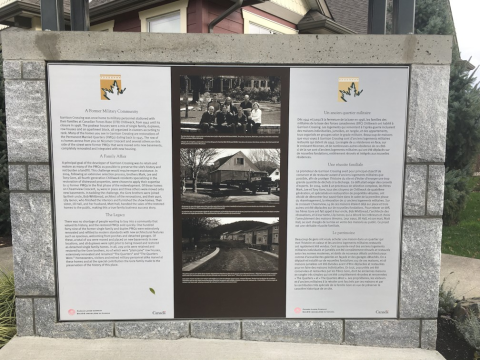
A Former Military Community

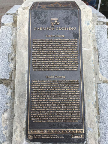
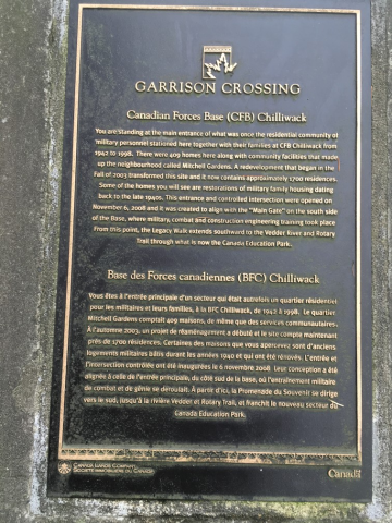
Garrison Crossing was once home to military personnel stationed with their families at Canadian Forces Base (CFB) Chilliwack, from 1942 until its closure in 1998. The postwar houses were a mix of single family, duplexes, row houses and an apartment block, all organized in clusters according to rank. Many of the homes you see in Garrison Crossing are restorations of the Permanent Married Quarters (PMQs) dating back to 1945. The row of 11 homes across from you on Nicomen Crescent and several others on this side of the street were former PMWs that were moved onto new basements, completely renovated and integrated with new housing.

A Family Affair

A principal goal of the developer of Garrison Crossing was to retain and restore as many of the PMQs as possible to preserve the site's history and not burden a landfill. This challenge would require expert assistance. In 2004, following an extensive selection process, brothers Mark, Lee and Tony Gore, all fourth-generation Chilliwack residents specializing in the restoration of distressed properties, were chosen to apply their expertise to 17 former PMQs in the first phase of the redevelopment. Of these homes on Cheamview Crescent, 14 were in place and three others were moved onto new basements. In tackling the challenge, the Gore brothers were joined by their uncle, Bob Whitbread, architect of the renovations, and their aunt, Lily Isenor, who finished the interiors and furnished the show homes. Their sister, Jill Hall, and her husband, Matt Hall, handled the sales of the restored homes to the public, making this a true family business success story.

The Legacy

There was no shortage of people wanting to buy into a community that valued its history, and the restored PMQs sold quickly. One jundred forty-nine of the former single family and duplex PMQs were extensively renovated and refitted to modern standards with new architectural features such as spacious, welcoming front porches and detached garages. Of these, a total of 102 were moved and placed on new basements in the new locations, and 18 duplexes were split prior to being moved and restored as detached single family homes. In all, 209 units were retained and restored by the Gore brothers, 60 of which were "plain jane" row houses, extensively renovated and renamed "The Quarters" and "The Quarters West." Homeowners, visitors and retired military personnel alike marvel at these homes and at the special contribution the Gore family made to the preservation of the history of this place.

[right side/droite]

Un ancien quartier militaire

Dès 1942 et jusqu'à la fermeture de la base en 1998, les familles des militaires de la base des forces canadiennes (BFC) Chilliwack ont habité à Garrison Crossing. Les logements qui remontent à l'après-guerre incluaient des maisons individuelles, jumelées, en rangée, et des appartements, tous organisés en groupes selon le grade militaire. Beaucoup de maisons que vous voyez à Garrison Crossing sont d'anciens logements militaires restaurés qui datent de 1945. La rangée de 11 résidences en face, sur le croissant Nicomen, et de nombreuses autres résidence de ce côté-ci de la rue sont d'anciens logements militaires qui ont été déplacés sur de nouvelles fondations, entiérement rénovés et intégrés aux nouvelles résidences.

Une réussite familiale

Le promoteur de Garrison Crossing avait pour principal objectif de conserver et de restaurer autant d'anciens logements militaires que possible, agin de protéger l'histoire du site et d'éviter d'envoyer une trop grande quantité de déchets à la décharge. Ce défi allait exiger des conseils d'experts. En 2004, suite à un processus de sélection complexe, les frères Mark, Lee et Tony Gore, tous des citoyens de Chilliwack de quatrième génération, et spécialisés en restauration de propriétés véOustes, ont décidé de démontrer leur savoir-faire dans le cadre de la première phase du réaménagement, la rénovation de 17 anciens logements militaires. Sur le croissant Cheamview, 14 de ces maisons étaient déjà sur place et trois autres ont été déplacées sur de nouvelles fondations. Pour relever ce défi, les frères Gore ont fait appel à leur oncle, Bob Whitebread, l'architecte des rénovations, et à leur tante, Lily Isenor, qui a décoré les intérieurs et choisi l'ameublement des maisons [?]. Leur sœur, Jill Hall, et son mari, Matt Hall, se sont chargés de la mise en ventre des maisons au public. Ce projet est une véritable réussite familiale.

Le patrimoine

Beaucoup de gens ont voulu acheter une maison dans un quartier qui met l'histoire en valeur et les anciens logements militaires restaurés ont rapidement été vendus. Cent quarante-neuf des anceins logements militaires individuells et jumelés ont été complètement rénovés et restaurés selon les normes modernes, et dotés de nouveaux détails achitectureaux comme d'accueillantes galeries en façade et des garages détachés. On a déplacé et iratallé sur de nouvelles fondations 102 de ces maisons, et 18 maisons jumelées ont été divisées avant d'ètre déplacées et restaurées pour en faire des maisons indivuelles. En tout, 209 unités ont été conservées et restaurées par les frères Gore, dont 60 anciennes maisons en rangée très simples qui ont été complètement rénovées et renommées «The Quarters» et «The Quarters West». Les propriétaires, les visiteurs et d'anciens militaires à la retraite sont fascinés par ces maisons et par la contribution très spéciale de la familie Gore en vue de préserver le caractère historique de ce site.

Image
Photo Credit
Jim Harris, CFB Chilliwack Historical Society
Caption
interpretive panel
War or Conflict Term
Province
!4v1629898458088!6m8!1m7!1ssDV9jnijP2lvx7ddwlTOmw!2m2!1d49.10628847583627!2d-121.9730587317663!3f36.562756888229785!4f-8.911070008867241!5f1.9096568013479493
Body Content

This interpretive panel was installed as part of the Garrison Crossing Legacy Walk.

City
Chilliwack
Country
Type Description
Interpretive Panel
Memorial CF Legacy ID
10571
City/Municipality
Chilliwack
Memorial Number
59006-051
Type
Address
Nicomen Crescent and Sappers' Way
Location
Garrison Crossing
in Canada
Yes
GPS Coordinates
49.1075184, -121.9710834
Inscription

GARRISON CROSSING

Sapper Apprentices

From 1953 to 1967 the Base offered a unique Sapper Apprentice
Program that provided youth 16 to18 years of age with specific
trades training and academic upgrading. This was one of seven
specialized youth programs offered across Canada. These
apprentices signed on for seven years of serve, but could be
released after five. A total of 847 Sapper apprentices
commenced the two-year initial training period that consisted
of 1/2 day each of military training and academics. Before they
were allowed out in public, the apprentices had to learn to
dress and act like soldiers. Their social life was strictly controlled
with a limited number of weekend 'off base' passes issued.
Although a demanding program, these apprentices gained
military status, were paid 1/2 salary until their 17th birthday
and the camaraderie established lasting bonds between them.
They graduated with increased academic qualifications and
qualified as Group 1 Field Engineers. Sappers' Way was opened
and dedicated in 2006.

Apprentis Sapeurs

De 1953 à 1967, la base offrait le programme original des
apprentis sapeurs, qui donnait aux jeunes de 16 à 18 ans une
formation spécialisée dans certains métiers, de même qu'un
enrichissemnt académique. Il s'agissait d'un de sept
programmes spécialisés destinés aux jeunes au Canada. Les
apprentis s'engageaient pendant sept ans, mai pouvaient
quitter le service après cinq ans. En tout, 847 apprentis sapeurs
ont suivi la formation initiale de deux ans, un programme
composé moité-moité de formation militaire et de course
académiques. Avant de sortir en public, les apprentis ont dù
apprendre à se vêtire et à agir selon le code militaire. On
contrôlait strictement leurs allées et venues, et le nombre de
laissez-passer pour les sorties de fin de semaine était très
restreint. Le programme était rigoureux, les apprentis avaient
le statut de militaires et, jusqu'à leur 17e anniversaire, ne
touchaient qu'un demi-salaire, mais une solide camaraderie
régnait parmis eux et ces liens ont été durables. Les apprentis
sapeurs obtenaienet des qualifications supérieures et, une fois
diplômés, appartenaieent au corps de sapeurs du 1er Escadron
de campagne. La rue Sappers' Way a été inaugurée en 2006.

CANADA LANDS COMPANY
SOCIÉTÉ IMMOBLIÈRE DU CANADA

Image
Photo Credit
Jim Harris, CFB Chilliwack Historical Society
Caption
plaque
War or Conflict Term
Province
!4v1629833733333!6m8!1m7!1szyMTq6fZTqDpFhdTz5qxQw!2m2!1d49.10751839741402!2d-121.9710834340575!3f290.794275325107!4f-6.101204620676356!5f0.7820865974627469
Body Content

This plaque was installed as part of the Garrison Crossing Legacy Walk.

City
Chilliwack
Country
Type Description
Plaque (on plinth)
Memorial CF Legacy ID
10570