Other

City/Municipality
Geographical feature
Memorial Number
60001-020
Type
Address
River
Location
155 km northeast of Dawson
in Canada
Yes
GPS Coordinates
65.358867489666, -138.29678957134
Inscription

[on maps]

Engineer Creek

Image
Caption
Map - Location of Engineer Creek (Map by Natural Resources Canada/ Government of Canada)
Province
Body Content

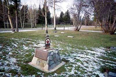
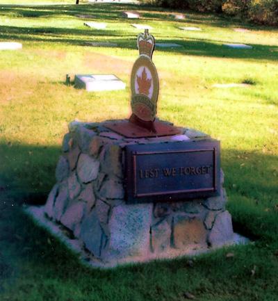
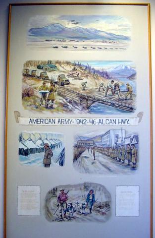
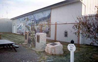
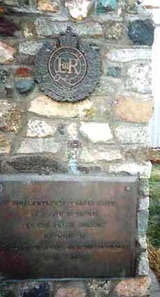
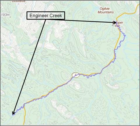
This geographical feature was named Engineer Creek as a tribute to the Canadian Military Engineers, who built the Ogilvie River Bridge (George A. Jeckle Bridge). The creek runs parallel to the Dempster Highway for about 30 km and empties into the Ogilvie River next to the Ogilvie River Bridge. It was named by the Government of Yukon on 24 September 1981, marking the 10th anniversary of the completion of the bridge.


Excerpt from “The History of the Canadian Military Engineers”, Volume 3, pages 370-371:


“The field squadrons also became involved in the construction of bridges and airfields in the North starting in the early 1970s in support of a government program of northern development. The remote locations and hostile climates offered construction challenges and hardships that were akin to training for combat missions. Construction of the first project, the Ogilvie River bridge in the Yukon, was undertaken by 3 Field Squadron and 1 CEU as a joint undertaking with the Department of Public Works….”


“Planning and reconnaissance had begun in June 1969 and the agreement between Public Works and the Department of National Defence called for the completion of the project- a 360-foot, three-span,…. (bridge) by December 1971. Construction start planned for July 1970 was delayed by a year because the civilian contractor building the Dempster Highway was unable to push the highway to the Ogilvie River until October 1970.”


“….sappers from 3 Field Squadron and support elements from 1 Service Battalion worked 14-hour days, seven days a week, from May to September (1971) to complete the structure…... Construction went smoothly and the bridge….. was opened and handed over to the Department of Public Works on 3 September 1971.”

City
Geographical feature
Country
Type Description
Geographic Location
Photo Credit
Richard Turcotte
Memorial CF Legacy ID
9624
City/Municipality
Whitehorse
Memorial Number
60001-019
Type
Location
Sapper Hill
in Canada
Yes
GPS Coordinates
65.35908, -138.26096
Inscription

(needs further research/recherche incomplète)

Image
Caption
Sapper Hill hike map
1 of 2 images
Image
Caption
Sapper Hill
1 of 2 images
Province
Body Content

Was named to honour the Canadian Military Engineer involvement in the construction of that bridge.

City
Whitehorse
Country
Type Description
Landmark (hill)
Memorial CF Legacy ID
6848
City/Municipality
Whitehorse
Memorial Number
60001-017
Type
Address
6th Avenue
Location
Pioneer Cemetery
in Canada
Yes
GPS Coordinates
60.7191972, -135.0610157
Inscription

DEDICATED
TO THE GLORY OF GOD
AND TO THOSE
WHO SERVED
THEIR COUNTRY

VALOUR

AT THE GOING DOWN
OF THE SUN
AND IN THE MORNING
WE WILL REMEMBER THEM

ERECTED BY THE
ROYAL CANADIAN LEGION
WHITEHORSE (PACIFIC) BRANCH #254
1989 A.D.

one middle quality image in memorial electronic file. Bad quality image in paper file .

Image
Photo Credit
Tom Paterson, Event Coordinator/coordonnateur des activités; Joe Goodeill
Caption
front view
1 of 2 images
Image
Caption
details
1 of 2 images
Province
!4v1622556784049!6m8!1m7!1srm7M2LuKfEeBmayWz4zjpg!2m2!1d60.71919721810303!2d-135.0610156918063!3f261.05767981554976!4f-2.3145080109785!5f3.325193203789971"
Body Content

This memorial is dedicated to all veterans. It was erected by the Royal Canadian Legion Whitehorse (Pacific) Branch 254. Comrade Don Knutson, Associate Member was chairman of the committee.

City
Whitehorse
Country
Type Description
Stele (stone)
Memorial CF Legacy ID
5207
City/Municipality
Whitehorse
Memorial Number
60001-016
Type
Address
Grey Mountain Rd
Location
Grey Mountain Cemetery
in Canada
Yes
GPS Coordinates
60.712059375811, -135.00870818056
Inscription

LEST WE FORGET

Image
Photo Credit
Tom Paterson; Joe Goodeill
Caption
front view
1 of 3 images
Image
Caption
front side view
1 of 3 images
Image
Caption
plaque
1 of 3 images
Province
!4v1622556664193!6m8!1m7!1sZJLu2FFM8OT5YnvEEyuOIw!2m2!1d60.71092994824594!2d-135.0123378433926!3f5.637474176527917!4f1.4238927553916199!5f1.6873979186220724"
Body Content

This memorial is dedicated to all those who fought for Canada. When the City of Whitehorse established this area lots were allocated to Masonic Lodge, Yukon Order of Pioneers, Elks and Legion. Each club was allowed to identify their area by installing an emblem. Their emblem identifies the Legion plot of land.

City
Whitehorse
Country
Type Description
Cairn with plaques
Memorial CF Legacy ID
5856
City/Municipality
Whitehorse
Memorial Number
60001-015
Type
Address
30 Electra Crescent
Location
Transportation Museum
in Canada
Yes
GPS Coordinates
60.71194, -135.07951
Inscription

(needs further research/recherche incomplète)

Image
Photo Credit
Tom Paterson
Caption
Alaska Highway Mural and memorial collection.
Province
!4v1622556496855!6m8!1m7!1stKRwvibaJnOww0xL3AFmyg!2m2!1d60.71196246339376!2d-135.079602743239!3f76.7648995740676!4f-1.5471240700343145!5f0.7820865974627469"
Body Content

This mural depicts the original construction of the Alaska Highway by the United States Army Engineers.

City
Whitehorse
Country
Type Description
Mural
Memorial CF Legacy ID
5854
City/Municipality
Whitehorse
Memorial Number
60001-014
Type
Address
2121 2nd avenue
Location
City Hall
in Canada
Yes
GPS Coordinates
60.72083, -135.05258
Inscription

AMERICAN ARMY - 1942-46 - ALCAN HIGHWAY

Image
Photo Credit
Tom Paterson
Caption
panel
1 of 2 images
Image
Caption
panel
1 of 2 images
Province
!4v1622556408008!6m8!1m7!1sjq-3ncKjgq3nJle0SeDVIA!2m2!1d60.72078605786718!2d-135.0531014370571!3f76.14162672765289!4f-1.2501824992650654!5f0.7820865974627469"
Body Content

This memorial commemorates the American Army and the construction of the ALCAN Highway. It was erected by the City of Whitehorse.

City
Whitehorse
Country
Type Description
Painted wood panel
Memorial CF Legacy ID
5855
City/Municipality
Whitehorse
Memorial Number
60001-012
Type
Address
30 Electra Crescent
Location
Transportation Museum
in Canada
Yes
GPS Coordinates
60.7118554, -135.0796085
Inscription

HISTORIC
MILE
917

Image
Photo Credit
Tom Paterson
Caption
Highway marker
1 of 2 images
Image
Caption
Memorial collection
1 of 2 images
War or Conflict Term
Province
!4v1622556260646!6m8!1m7!1sQjAnonTldkMbltnGbrBQGA!2m2!1d60.71185535981429!2d-135.0796085352519!3f87.31146181904371!4f-19.01664950798849!5f1.459925173732843"
Body Content

A number of markers along the highway indicate the original distance in miles to Mile 0 in Dawson Creek, British Columbia. One of those markers is located beside the cairns. The Alaska Highway was originally constructed during the Second World War to connect the lower 48 with Alaska. It starts in Dawson Creek, British Columbia and goes north 1,387 miles ending in Delta Junction, Alaska.

City
Whitehorse
Country
Type Description
Highway marker - part of a larger collection
Memorial CF Legacy ID
5852
City/Municipality
Whitehorse
Memorial Number
60001-011
Type
Address
30 Electra Crescent
Location
Transportation Museum
in Canada
Yes
GPS Coordinates
60.7119625, -135.0796027
Inscription

ON NOVEMBER 20, 1942 THE ALASKA HIGHWAY
WAS COMPLETED AS A WARTIME EXPEDIENT.
TODAY, TWENTY-FIVE YEARS LATER, DURING THE
CENTENARIES OF CANADA AND THE STATE OF
ALASKA THIS PLAQUE COMMEMORATES THAT
EVENT AND HONORS THE BRAVE MEN WHOSE
[?] EFFORTS MADE THE HIGHWAY A
REALITY AND INDEED AN AVENUE TO THE
GLORIOUS FUTURE OF BOTH ALASKA AND THE
YUKON TERRITORY.

NOVEMBER 30, 1967

Image
Photo Credit
Tom Paterson
Caption
plaque
1 of 2 images
Image
Caption
memorial collection
1 of 2 images
War or Conflict Term
Province
!4v1622556099492!6m8!1m7!1stKRwvibaJnOww0xL3AFmyg!2m2!1d60.71196246339376!2d-135.079602743239!3f109.5795832690057!4f-14.731825140838382!5f0.4000000000000002"
Body Content

The decorative fence and plaques affixed to it do not specifically commemorate military units, but rather the importance of the highway itself.

City
Whitehorse
Country
Type Description
Plaque on fence - part of a larger collection
Memorial CF Legacy ID
5851
City/Municipality
Whitehorse
Memorial Number
60001-010
Type
Address
30 Electra Crescent
Location
Transportation Museum
in Canada
Yes
GPS Coordinates
60.7119625, -135.0796027
Inscription

AT THIS SITE ON 1 APRIL 1964
THE CANADIAN ARMY
HANDED OVER RESPONSIBILITY
FOR THE ALASKA HIGHWAY AND
THE NORTHWEST HIGHWAY SYSTEM
TO THE FEDERAL DEPARTMENT OF
PUBLIC WORKS

Image
Photo Credit
Tom Paterson
Caption
plaque
1 of 2 images
Image
Caption
memorial collection
1 of 2 images
War or Conflict Term
Province
!4v1622555713675!6m8!1m7!1stKRwvibaJnOww0xL3AFmyg!2m2!1d60.71196246339376!2d-135.079602743239!3f127.9626481297015!4f-13.124136098949094!5f1.8123517097377246"
Body Content

This memorial commemorates when the Canadian Army gave responsibility of the Alaska Highway to the federal department of Public Works.

City
Whitehorse
Country
Type Description
Stone cairn with bronze plaques (part of a larger memorial collection)
Memorial CF Legacy ID
5850
City/Municipality
Whitehorse
Memorial Number
60001-009
Type
Address
30 Electra Crescent
Location
Transportation Museum
in Canada
Yes
GPS Coordinates
60.7119625, -135.0796027
Inscription

THIS MONUMENT COMMEMORATES 18 YEARS OF SERVICE ON THE ALASKA HIGHWAY BY UNITS OF THE CORPS OF ROYAL CANADIAN ENGINEERS 1946-1964

Image
Photo Credit
Tom Paterson
Caption
plaques
1 of 2 images
Image
Caption
memorial collection
1 of 2 images
War or Conflict Term
Province
!4v1622555585666!6m8!1m7!1stKRwvibaJnOww0xL3AFmyg!2m2!1d60.71196246339376!2d-135.079602743239!3f135.71368996206746!4f-14.238188090588238!5f1.6692164491583603"
Body Content

The Yukon Transportation Museum at kilometre 1473.8 on the Alaska Highway includes a plaque that commemorates 18 years of service on the Alaska Highway by units of the Corps of Royal Canadian Engineers during 1946-1964. The museum also displays the pair of cairns and plaques (relocated from their original site at Mile 918) that recalls both the initial hand-over of the Canadian portion of the Alcan Highway from the US Army to the Canadian Army on 1 April 1946 and its subsequent transfer to the Department of Public Works on 1 April 1964.

City
Whitehorse
Country
Type Description
Cairn with bronze plaques (part of a larger memorial collection.
Memorial CF Legacy ID
5849