Parks

City/Municipality
Calgary
Memorial Number
48002-091
Type
Address
Valour Circle SW
Location
Currie
in Canada
Yes
GPS Coordinates
51.0177303, -114.1333303
Inscription

Valour Park

War or Conflict Term
Province
!4v1693404903940!6m8!1m7!1slz61D0l04dHs5QKi_zwxyA!2m2!1d51.01773030086314!2d-114.1333303150263!3f249.36024342320064!4f-1.4198857746669802!5f0.7820865974627469
Body Content

Valour Park features small, engineered bridges reminiscent of the ones Canadian Veterans would have used to cross bodies of water during ground warfare.

City
Calgary
Country
Type Description
Park
Memorial CF Legacy ID
11987
City/Municipality
Calgary
Memorial Number
48002-066
Type
Address
1221 2nd Street SW, Calgary, AB
Location
Central Memorial Park
in Canada
Yes
GPS Coordinates
51.0411442486, -114.06909483148
Image
1 of 3 images
Image
1 of 3 images
Image
1 of 3 images
Province
!4v1614781461471!6m8!1m7!1sCAoSLEFGMVFpcE9saUZZb0ZPZ19EaTZ4azVWLU5OUlJjRmdnRWJhaXJkWlhXXzgy!2m2!1d51.041549!2d-114.0682553!3f83.01625677140305!4f5.530873876203827!5f3.325193203789971"
Body Content

Memorial Park Library is a classically-inspired, early 20th century, two-storey sandstone building located on 1.93 hectares in Central Memorial Park in downtown Calgary. An east-facing portico, set a top a series of granite steps, is adorned with iconic columns and a skillfully-carved pediment, creating a dignified entry into the library. The building is topped with a low-hipped roof, and expertly executed decoration. The park on which the library sits contains several objects, including:

  • An equestrian statue, added in 1914; The Horseman of the Plains, commemorating the South African War, located in the centre of the park’s oval.
  • First World War Memorial, added in 1924, located at the east end of the park in front of the library.
  • Cenotaph and accompanying benches, added in 1928, located at the west end of the park.
  • Federal Geodetic Survey marker, added in 1928, located at the east end of the park’s oval.
  • Water fountain commemorating the 50th Battalion, Canadian Expeditionary Force, added in 1930.
  • Eternal flame memorial located to the east of the cenotaph, added 1967.
  • Royal Canadian Legion Commemorative Medallion, located to the West of the cenotaph, added 1994.
  • Second World War memorial, Burma Star, located near the cenotaph, added in 1996.
  • Memorial to the Australian and New Zealand armed forces located near the cenotaph, added in 2004.
City
Calgary
Country
Type Description
Park and library
Memorial CF Legacy ID
9113
City/Municipality
Esterhazy
Memorial Number
47014-008
Type
Address
Veterans Ave
Location
Peace Park
in Canada
Yes
GPS Coordinates
50.6547061, -102.0748819
Inscription

[cairn, upper plaque/tumulus, plaque du haut]

MAY ETERNAL PEACE RULE THROUGHOUT THE WHOLE WORLD WITH PEACE AND FRIENDSHIP BETWEEN ALL MANKIND

DEDICATED A PEACE PARK THIS 4TH DAY OF JUNE A.D. 1993

ROYAL CANADIAN LEGION NO. 249
TOWN OF ESTERHAZY

[cairn, lower plaque/tumulus, plaque du bas]

LEST WE FORGET

IN MEMORY OF ALL THOSE MEN AND WOMEN WHO GAVE THEIR LIVES FOR THEIR COUNTRY

WE WILL REMEMBER THEM

ESTERHAZY SASK. NO 249
LEGION BRANCH

Image
Photo Credit
Keith Inches
Caption
park (cairn front)
1 of 4 images
Image
Caption
park (cairn front and left side)
1 of 4 images
Image
Caption
park (cairn plaques)
1 of 4 images
Image
Caption
park (cairn front)
1 of 4 images
Province
!4v1621601465374!6m8!1m7!1sLLMIeoc_IpvmRwMC9j7_Sg!2m2!1d50.65470609851686!2d-102.0748819073293!3f359.90243750376067!4f2.9955296234151376!5f1.5517655602182976"
Body Content

Dedicated a Peace Park on 4 June 1993, this memorial is marked by a fieldstone cairn erected by Royal Canadian Legion Branch No. 249. It is dedicated to Canada's war dead.

City
Esterhazy
Country
Type Description
Park
Memorial CF Legacy ID
1135
City/Municipality
Saskatoon
Memorial Number
47012-024
Type
Address
Between University Bridge (25th Street Bridge) and Broadway Bridge
Location
Kiwanis Memorial Park Grounds
in Canada
Yes
GPS Coordinates
52.124457050079, -106.6593748357
Inscription

[wall/mur]

KIWANIS MEMORIAL PARK

Image
Photo Credit
Keith Inches
Caption
park (wall)
Province
!4v1621442668083!6m8!1m7!1s5xf2TffERRei7-yced665w!2m2!1d52.12463396986778!2d-106.6600153480267!3f109.16575689656716!4f3.503531176817731!5f0.7820865974627469"
Body Content

Located between the Broadway Bridge and the 25th Street Bridge and surrounding Delta Bessborough Hotel, beautiful Kiwanis Memorial Park is recognized as one of the finest urban parks in Canada. Designated Kiwanis Memorial Park by motion of City Council on April 1, 1946, it has an interesting and unique history. From 1907 to 1912, ashes from a local power plant were hauled to this area and local contractors were encouraged to dispose of their excess fill there from the time of Saskatoon’s first building boom in 1911 until the Thirties. In 1935, using funds from the CNR as part of an agreement for the creation of the Bessborough Hotel, the dumpsite was transformed into the park site. It was levelled and improved with grass, trees and shrubs throughout the Thirties, including a tree planted in 1938 near the 20th Street entrance to commemorate the contribution of Mr. Argue, a member of the Kiwanis Club and the Parks Board. The City of Saskatoon and Meewasin Valley Authority have continued to improve Kiwanis Memorial Park by constructing a promenade along Spadina Crescent between the University Bridge and the Broadway Bridge. Memorial Park attractions to enjoy along this prairie Path of History include: 1. The Northwest Rebellion (1885) [statue] 2. The South African (Boer) War (1899-1902) [bench] 3. Vimy Memorial Band Shell 4. The Memorial Fountain of Youth 5. The Korean War (1950-1953) [bench] 6. Thompson Belvedere (pavilion] 7. Ramon John Hnatyshyn Statue 8. Spirit of Youth [structure] 9. Century 100 Capsule 10. Bessborough Hotel 11. Kiwanis Park Gate 12. St. Andrew’s Presbyterian Church (Spadina and 20th Street) 13. St. Paul’s Cathedral (720 Spadina Crescent) 14. Knox United Church (838 Spadina Crescent) 15. St. John’s Cathedral (816 Spadina Crescent) Source: Path of History - Kiwanis Memorial Park brochure

City
Saskatoon
Country
Type Description
Park
Memorial CF Legacy ID
2674
City/Municipality
Wawota
Memorial Number
47011-112
Type
Address
Railroad Avenue
Location
Veterans Memorial Park
in Canada
Yes
GPS Coordinates
49.9039044, -102.0236756
Inscription

[archway/arche]

VETERANS MEMORIAL PARK
LEST WE FORGET

Image
Caption
Veterans Memorial Park
War or Conflict Term
Province
!4v1621429469758!6m8!1m7!1sKiQdADG9zTY3VBrPlQkFUA!2m2!1d49.90390714684523!2d-102.0236680312772!3f157.50017604365183!4f0.7829291342900007!5f1.5908682484421468
Body Content

Veterans Memorial Park is where people can come and remember loved ones, relatives or friends who paid the supreme sacrifice in the First and Second World Wars. The park is bordered by a chain link fence on three sides and an ornamental steel fence facing the street with a wide gateway. 

The walkway from the street to the memorial is wide enough to walk two abreast and is used for wreath laying ceremonies on November 11. Classes of school children visit the park each year prior to November 11. There are two cement benches for visitors to sit and rest, these were donated by individuals.

City
Wawota
Country
Type Description
Park, archway, bench
Photo Credit
Kenneth N. Colborn
Memorial CF Legacy ID
7945
City/Municipality
Carnduff
Memorial Number
47011-061
Type
Address
Broadway and Highway 18
Location
Memorial Park
in Canada
Yes
GPS Coordinates
49.1765279, -101.7949581
Inscription

CARNDUFF
1905 - 1985

1912 MEMORIAL PARK 1985

R.M. OF
MOUNT PLEASANT
1912 - 1985

Image
Photo Credit
Norman Walker
Caption
park entrance
Province
!4v1621348512145!6m8!1m7!1sL8uLaiikIRAj9OpL8ZwneQ!2m2!1d49.1765278687139!2d-101.7949580745807!3f50.875694048621774!4f-0.9671027297924439!5f0.7820865974627469"
Body Content

This memorial is dedicated to the honoured dead. It was erected by the Royal Canadian Legion and the Town of Carnduff.

City
Carnduff
Country
Type Description
Park
Memorial CF Legacy ID
6746
City/Municipality
Saskatoon
Memorial Number
47010-044
Type
Address
Rockingham Avenue and Ortona Street
Location
Montgomery Place
in Canada
Yes
GPS Coordinates
52.1110606, -106.7311032
Inscription

[park sign/signe du parc]

MONTGOMERY PARK

[plaque]

Field Marshall B.L. Montgomery (1887 – 1976)

Montgomery was one of the most inspirational British military
leaders of the Second World War. After significant victories over
German General Erwin Rommell in North Africa (1942 – 1944), he
was promoted to Field Marshall in command of British and
Canadian troops. Montgomery presided over the Battle of Arnhem
and Normandy and accepted the formal surrender of the German
military at Lüneberg Heath on May 4th, 1945. His flair for
command and the absolute belief in his infallibility made him a
legendary, if not always popular, leader.

Image
Photo Credit
Montgomery Place Community Association
Caption
Montgomery Park Plaque
Province
!4v1718369897170!6m8!1m7!1svc0HdLjxzpZWsCMn0akXiQ!2m2!1d52.11106063478562!2d-106.731103211282!3f58.25422038544875!4f-9.433823983359744!5f1.7815123749283663
Body Content

Montgomery Park is named in honour of Field Marshall Bernard Law Montgomery, 1st Viscount Montgomery of Alamein, KG, GCB, DSO, PC. It is located in Montgomery Place, an area developed in 1946 to house returning Second World War Veterans and their families. Most streets and parks in the area are named for prominent military members, famous battles, and military units. A duplicate of this plaque is located at the Montgomery Place Memorial.

In 2004, the Montgomery Place Community Association embarked on a project to explain the choice of names for Montgomery Place streets. The research and writing were undertaken by Kevin Gooding who was the Finance Director at the time, with help from President Jim Earle.

The signs were produced at Abe’s Sign Design Group of Saskatoon, with owner Gerry Tunicliffe giving the Association his whole-hearted support. Gerry even offered the Cassino Avenue sign free-of-charge, since his father had fought at the Battle of Monte Cassino. With interest and dedication, Gerry was also a great help to Kevin tracking down photos for the signs.

On September 22, 2007, Kevin, Jim and Vice-President Dave Price, along with Secretary Larry Rempel, Communications Director Gary Berg and resident Don Janzen, rented an auger and then dug, filled, tamped and installed the first 16 signs. Three more signs were installed later.

City
Saskatoon
Country
Type Description
Park
Memorial CF Legacy ID
9105
City/Municipality
Saskatoon
Memorial Number
47010-040
Type
Address
Cassino Avenue
Location
Montgomery Place
in Canada
Yes
GPS Coordinates
52.1068775, -106.728337
Inscription

[park sign/signe du parc]

LT. COL. D. WALKER PARK

[plaque]

Lt. Colonel Drayton E. Walker (1900 – 1975)

Born in Maple Creek Saskatchewan, Drayton Ernest Walker
achieved prominence as both a veteran and an educator. He left a
teaching career to serve with the Saskatoon Light Infantry in
1939, fighting in the invasion of Sicily. He became commanding
officer achieving the rank of Lieutenant Colonel. Injured in 1943,
he received the Distinguished Service Order. Walker returned to
Saskatoon where he became Principal of Bedford Road Collegiate
and later the first Principal of Mount Royal Collegiate. He retired in
1966 after a 3 year term as Principal of the Armed Services School
in Marville, France.

Image
Photo Credit
Saskatoon Star Phoenix
Caption
Lieutenant-Colonel Drayton Walker kissing his wife Margaret, October 3, 1945,
1 of 3 images
Image
Photo Credit
Montgomery Place Community Association
Caption
Lt. Col. D. Walker Park Plaque
1 of 3 images
Image
Photo Credit
Saskatoon Star Phoenix
Caption
Lieutenant-Colonel Drayton Walker leading the Saskatoon Light Infantry parading down 21st Street, October 3, 1945,
1 of 3 images
Province
!4v1718301610516!6m8!1m7!1sIiQyRE6V8h3_tyu0LAQ0KA!2m2!1d52.10687745021593!2d-106.7283370293848!3f354.03347311961164!4f-17.41687857621035!5f2.1636453454087854
Body Content

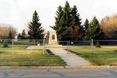
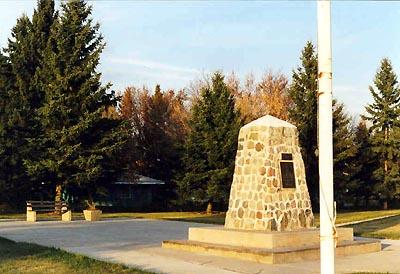
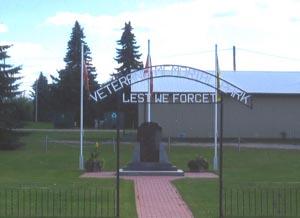
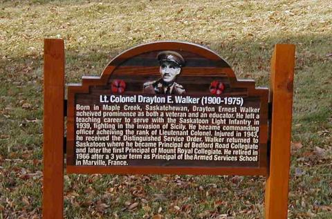
This park is named in honour of Lieutenant-Colonel Drayton Ernest Walker, DSO, Commanding Officer of the Saskatoon Light Infantry during the Second World War. It is located in Montgomery Place, an area developed in 1946 to house returning Second World War Veterans and their families. Most streets and parks in the area are named for prominent military members, famous battles, and military units. Lieutenant-Colonel D. Walker Park was named by the City of Saskatoon in the mid to late 1960s.

Drayton Walker and his wife Margaret had three sons — Peter, Phil and Teddy. The oldest was nine when their dad headed into the Second World War in 1939. He left behind a wide array of students, kids he educated and coached since taking his first teaching job in Prince Albert in 1922. He was teaching at City Park Collegiate when he left for the war.

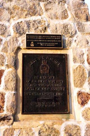
Drayton was a former University of Saskatchewan track star, which would prove beneficial overseas. Ten days before Christmas in 1943, a Quebec battalion was pinned down at the town of Casa Berardi, Italy. Drayton commanded a Saskatoon Light Infantry machine-gun support group that rolled in to help during the vicious, eight-day Battle of Ortona. He chose to personally co-ordinate the defensive tasks of his unit, occupied observation posts in the most forward infantry positions, and moved skillfully from post to post under heavy enemy fire. Under his direction, mortars and machine guns engaged the enemy with devastating results. Hit by shrapnel to the knee and hand, he continued to direct the fire of his weapons until the retention of the position was assured. Still on foot, he threaded his way back to brigade headquarters across ground swept by enemy fire and provided crucial information. His actions contributed greatly to the success not just of that operation, but of the ones that soon followed and he was awarded a Distinguished Service Order.

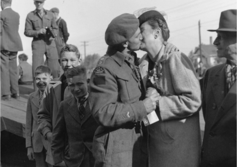
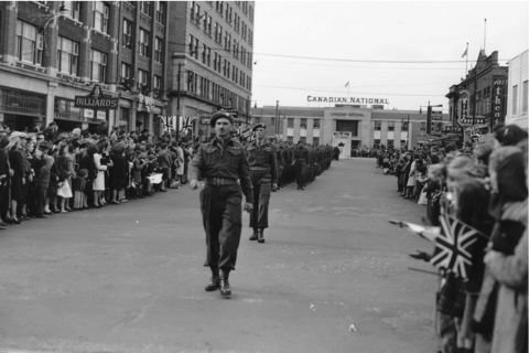
Shortly after Ortona, he was promoted to Lieutenant-Colonel and took over the battalion command in January 1945.  In October 1945, he returned home to his family and sealed it with a kiss to his wife, while their three sons stood in the background. His homecoming was photographed and ran on page 5 of the Saskatoon Star Phoenix. The boys hadn’t seen their father since he returned to Canada in 1942 for an instructional tour. After the kiss, soldiers paraded through Saskatoon’s downtown with Drayton at the front, leading his troops one last time.

Margaret experienced grievous loss during the war. She’d raised three boys, mostly on her own, in the six years since Drayton left to fight, and she’d also lost a brother. Her brother, William Campbell, was the commanding officer of HMCS Louisburg in 1943 when it was sunk by enemy dive bombers and torpedo planes in the Mediterranean. He received a posthumous citation for saving many lives, due to his prompt action. His bravery cost him his life.

Drayton was the principal at Bedford Road Collegiate starting in 1954, moving over from his job teaching history at Nutana Collegiate, before becoming Mount Royal Collegiate's first principal when it opened in 1960. The school’s motto, “Truth, Honour and Wisdom” was taken from Drayton’s wartime regiment. He later spent three years in France, serving as the principal of the Canadian Armed Services School. Drayton died on November 15, 1975, at the age of 75.

In 2004, the Montgomery Place Community Association embarked on a project to explain the choice of names for Montgomery Place streets. The research and writing were undertaken by Kevin Gooding who was the Finance Director at the time, with help from President Jim Earle.

The signs were produced at Abe’s Sign Design Group of Saskatoon, with owner Gerry Tunicliffe giving the Association his whole-hearted support. Gerry even offered the Cassino Avenue sign free-of-charge, since his father had fought at the Battle of Monte Cassino. With interest and dedication, Gerry was also a great help to Kevin tracking down photos for the signs.

On September 22, 2007, Kevin, Jim and Vice-President Dave Price, along with Secretary Larry Rempel, Communications Director Gary Berg and resident Don Janzen, rented an auger and then dug, filled, tamped and installed the first 16 signs. Three more signs were installed later.

City
Saskatoon
Country
Type Description
Park, plaque
Memorial CF Legacy ID
9101
City/Municipality
Saskatoon
Memorial Number
47010-004
Type
Address
3306 Mountbatten Street
Location
Montgomery Place
in Canada
Yes
GPS Coordinates
52.1081361, -106.7300721
Inscription

GOUGEON PARK

Province
!4v1718373782211!6m8!1m7!1sU9eSzo2m5G0dHkt1IYK-qA!2m2!1d52.10813614036412!2d-106.7300721065778!3f359.3031225556421!4f-9.09070271714755!5f0.7820865974627469
Body Content

Xavier “Louie” Gougeon came to Saskatoon in 1881 and returned a few years later with his wife and first child. He was a young man in his late twenties at time.

Gougeon played a role on the steamship at Fish Creek during the Northwest Resistance in 1885. He was a trooper on board the steamer Northcote and was subsequently awarded the North West Canada Medal and Clasp. He came to Saskatoon and acquired on land on the east half of 22-36-6-W3rd. This homestead was just west of present-day Gougeon Park, where 11th Street west meets Highway 7 today. In 1967, to honour Gougeon’s pioneer contribution to Saskatoon, the City of Saskatoon officials named the park south of St. Dominic School – Gougeon Park.

City
Saskatoon
Country
Type Description
Park
Memorial CF Legacy ID
12569
City/Municipality
Saskatoon
Memorial Number
47010-003
Type
Address
Simonds Avenue
in Canada
Yes
GPS Coordinates
52.1076401, -106.7393182
Inscription

[park sign/signe du parc]

LT. GEN. G.G. SIMONDS PARK

Province
!4v1718304775605!6m8!1m7!1svN_v-gL2xlpIsWdZsKjW1Q!2m2!1d52.10764006133824!2d-106.7393181724713!3f112.83151866480463!4f-12.469036007945917!5f2.0953929367797652
Body Content

This park is named in honour of Lieutenant-General Guy Granville Simonds, CC, CB, CBE, DSO, CD, Commander II Canadian Corps and Acting Commander First Canadian Army during the Battle of the Scheldt in 1944 and Chief of the General Staff in 1951. It is located in Montgomery Place, an area developed in 1946 to house returning Second World War Veterans and their families. Most streets and parks in the area are named for prominent military members, famous battles, and military units.

In 2004, the Montgomery Place Community Association embarked on a project to explain the choice of names for Montgomery Place streets. The research and writing were undertaken by Kevin Gooding who was the Finance Director at the time, with help from President Jim Earle.

The signs were produced at Abe’s Sign Design Group of Saskatoon, with owner Gerry Tunicliffe giving the Association his whole-hearted support. Gerry even offered the Cassino Avenue sign free-of-charge, since his father had fought at the Battle of Monte Cassino. With interest and dedication, Gerry was also a great help to Kevin tracking down photos for the signs.

On September 22, 2007, Kevin, Jim and Vice-President Dave Price, along with Secretary Larry Rempel, Communications Director Gary Berg and resident Don Janzen, rented an auger and then dug, filled, tamped and installed the first 16 signs. Three more signs were installed later.

City
Saskatoon
Country
Type Description
Park
Memorial CF Legacy ID
12568