Ontario

Province Code
ON
City/Municipality
Iroquois
Memorial Number
35083-048
Type
Address
6020 Carman Road
Location
In a park overlooking the Iroquois Locks Gauging Station
in Canada
Yes
GPS Coordinates
44.83143, -75.3135
Inscription

[front/devant]

Fort Needless
1812 – 1814
The Point Iroquois Blockhouse witnessed shots fired on U.S. General Wilkinson’s invasion forces. Captured and burned on 7th November 1813, the Blockhouse was rebuilt in 1814. As hostilities had ended in this area, British troops referred to it as “Fort Needless”.

Le Fort Inutile
1812 – 1814
Le Blockhaus de la Pointe des Iroquois fut témoin de coups de feu dirigés sur les forces envahissantes du Général américain Wilkinson. Pris et incendiés le 7 novembre 1813, le Blockhaus fut reconstruit en 1814. Les hostilités ayant cessé dans ce secteur, les troupes anglaises lui ont attribué le nom de « Fort Inutile ».

Donation by/ de Iroquois Matilda Lions Club

Image
Caption
plaque
1 of 2 images
Image
Caption
surroundings
1 of 2 images
Province
Body Content

This memorial, a stone plaque on a pedestal, is dedicated to the Iroquois Point Blockhouse.

City
Iroquois
Country
Type Description
Plaque (black stone) on a pedestal
Photo Credit
Richard Turcotte
Memorial CF Legacy ID
8727
City/Municipality
Iroquois
Memorial Number
35083-047
Type
Address
6020 Carman Road
Location
In a park overlooking the Iroquois Locks Gauging Station
in Canada
Yes
GPS Coordinates
44.83143, -75.3135
Inscription

[front/devant]

Capturing Point Iroquois
7 November 1813
U.S. General Wilkinson’s invasion force met armed resistance by some 200 troops of the 1st Regiment of Dundas Militia. 1200 troops of the 1st U.S. Rifle Regiment routed the militia and captured Point Iroquois. By delaying the enemy here and joining Lieutenant-Colonel Morrison’s forces, the 1st Regiment of Dundas Militia contributed significantly to the successful Battle of Crysler’s Farm.

Prise de la Pointe des Iroquois
7 novembre 1813
La force envahissante de Général américain Wilkinson a affronté la résistance armés de quelque 200 soldats du 1er Régiment de la Milice de Dundas. 1200 soldats du 1er Régiment des Fusiliers américain ont dérouté la Milice et capturé la Pointe des Iroquois. En retardant ici l’ennemi et en rejoignant les forces du Lieutenant-colonel Morrison, le 1er Régiment de la Milice de Dundas a contribué largement au succès du combat de la Ferme Crysler.

Donation by/ de Friendly Brothers (Masonic) Lodge No. 143 Iroquois

Image
Caption
plaque
1 of 2 images
Image
Caption
surroundings
1 of 2 images
Province
Body Content

This memorial, a stone plaque on a pedestal, is dedicated to the Battle of Iroquois Point.

City
Iroquois
Country
Type Description
Plaque (black stone) on a pedestal
Photo Credit
Richard Turcotte
Memorial CF Legacy ID
8726
City/Municipality
Iroquois
Memorial Number
35083-046
Type
Address
6020 Carman Road
Location
In a park overlooking the Iroquois Locks Gauging Station
in Canada
Yes
GPS Coordinates
44.83143, -75.3135
Inscription

1st Regiment Dundas Militia
1812 – 1814
Veterans of the American Revolutionary War, from the King’s Royal Regiment of New York and Jessop’s Corps of Loyal Rangers, made up the core of the 1st Regiment of Dundas Militia. In additiona, United Empire loyalists and other immigrant and Aboriginal men between 16 and 60 were obligated to take up arms in defence of “The Front”.

1er Régiment de la Milice de Dundas
1812 – 1814
Des vétérans de la Guerre Révolutionnaire américaine, du Régiment Royal de New York, et du Corps de la Garde Montée Loyale de Jessop, constituaient le noyeau du 1er Régiment de la Milice de Dundas. De plus, des loyalistes de l’Empire Uni ainsi que des hommes immigrants et Indigènes âgés de 16 à 60 ans furent contraints de prendre les armes à la défense du « Front ».

Donation by/ de Cardinal (Masonic) Lodge No. 491


Image
Caption
plaque
1 of 2 images
Image
Caption
surroundings
1 of 2 images
Province
Body Content

This memorial, a stone plaque on a pedestal, is dedicated to the 1st Regiment of Dundas Militia.

City
Iroquois
Country
Type Description
Plaque (black stone) on a pedestal
Photo Credit
Richard Turcotte
Memorial CF Legacy ID
8725
City/Municipality
Iroquois
Memorial Number
35083-045
Type
Address
24 Dundas Street
Location
Royal Canadian Legion, Branch 370
in Canada
Yes
GPS Coordinates
44.8471576, -75.3182048
Inscription

[plaque]

DUNDAS MURALS
"WE WILL REMEMBER THEM"

A LASTING TRIBUTE TO THE
YOUNG MEN AND WOMEN OF OUR AREA,
SOME BEING THE TENDER AGE OF 16
WHO FOUGHT BY LAND, SEA AND IN
THE AIR SO THAT WE COULD HAVE
THE FREEDOM WE ENJOY TODAY.
SOME WERE FORTUNATE AND
RETURNED HOME, SOME DIDN'T.

PLAQUES FUNDED BY ONTARIO TRILLIUM FOUNDATION

Image
Photo Credit
Richard Turcotte
Caption
We Will Remember Them mural
1 of 4 images
Image
Photo Credit
Tim Laye, Ontario War Memorials
Caption
We Will Remember Them mural
1 of 4 images
Image
Photo Credit
Tim Laye, Ontario War Memorials
Caption
We Will Remember Them mural
1 of 4 images
Image
Photo Credit
Tim Laye, Ontario War Memorials
Caption
plaque
1 of 4 images
Province
!4v1626113731785!6m8!1m7!1sliE4TZ45Gw36eZrEUj8BbQ!2m2!1d44.84716186962067!2d-75.31821171474913!3f332.25264410831517!4f1.4879576854498566!5f2.7210010146402963"
Body Content

This mural with a dedication plaque is dedicated to the members of the Iroquois area who served in war. It was presented by the Royal Canadian Legion Branch #370 on July 6, 2003.

City
Iroquois
Country
Type Description
Mural, plaque
Memorial CF Legacy ID
8724
City/Municipality
Mountain
Memorial Number
35083-044
Type
Address
10480 Clark Road
Location
Mountain Memorial Community Park
in Canada
Yes
GPS Coordinates
45.0329557, -75.4994137
Inscription

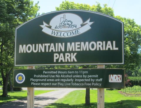
[park sign/enseigne du parc]

WELCOME

MOUNTAIN MEMORIAL
PARK

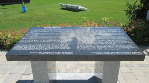
[dedication tablet/plaque commémorative]

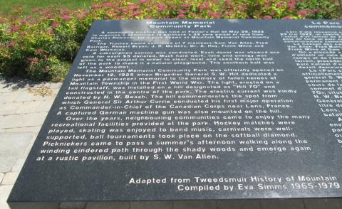
Mountain Memorial
Community Park

A community meeting was held at Foster’s Hall on May 29, 1922 to organize a committee to purchase a 22 acre parcel of land from Charles Robinson for a park known as Mountain Memorial Community Park.

The Trustee Board consisted of 7 members – Sam Van Allen, Fred Barrigan, Robert Bryan, J.R. McGillis, Dr. A. Hoy, Frank Milne and Sam Workman.

A subscription canvas was conducted. Each donor was allowed one vote for each $5 donated. Much hard work, time and energy was given to the project in order to clear, level and see the north half of the park to make it a natural playground. The southern half was left as a woodlot.

The Mountain Memorial Community Park was officially opened on 12 November 1925 when Brigadier General S.W. Hill dedicated a light as a permanent memorial to the memory of fallen heroes of Mountain Township in the First World War. The light, erected on a tall flagstaff, was installed on a hill designated “Hill 70” and constructed in the centre of the park. The electric current was kindly donated by N.W. Beach. The hill commemorates the spot from which General Sir Arthur Currie conducted his first major operation as Commander-in-Chief of the Canadian Corps near Lens, France. A captured German machine gun was also mounted on the hill.

Over the years, neighbouring communities came to enjoy the many recreational facilities provided at the park. Hockey matches were played, skating was enjoyed to band music, carnivals were well-supported, ball tournaments took place on the soft ball diamond. Picknickers came to pass a summer’s afternoon walking along the winding cindered path through the shady woods and emerge again at a rustic pavilion built by S.W. Van Allen.

-Adapted from Tweedsmuir History of Mountain
Comiled by Eva Simms 1965 – 1979.

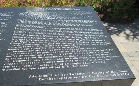
Le parc communautaire
commémoratif de « Mountain »

Lors d’une rencontre communautaire tenue à «Foster’s Hall» le 29 mai 1922, un comité fut crée dont le mandat était de procéder à l’achat d’un terrain de 22 acres appartenant à M. Charles Robinson pour en faire un parc connu aujourd’hui sous le nom de « Parc communautaire commémoratif de Mountain »

Le conseil des curateurs était composé de sept membres, sam Van Allen, Fred Barrigan, Robert Bryan, J.R. McGillis, Dr. A. Hoy, Frank Milne et Sam Workman.

On a procédé à une levée de fonds publique laquelle permettait d’obtenir un vote pour chaque 5$ versé. Beaucoup de travail dur, du temps et de l’énergie ont permis de défricher la partie nord du terrain, procéder à son nivelage puis l’ensemencer pour en faire un parc naturel d’amusement. La seconde moitié du terrain acquis devait demeurer boisé.

Le « Parc communautaire commémoratif de Mountain » a été officiellement ouvert au public le 12 novembre 1925. Le Brigadier général S.W. Hill a dédié une lampe comme élément commémoratif permanent à la mémoire des héros du comté de «Mountain» tués au cours de la Première Guerre mondiale. Cette lampe fut installée au sommet d’un grand mât érigé sur une petite colline appelée «Côte 70» située au centre de parc. L’alimentation électrique fut un don de N.W. Beach. Cette colline se veut un rappel de l’endroit où le Général Sir Arthur Currie a lancé sa première offensive majeure à titre de Commandant en chef des troupes d’infanterie canadiennes à Lens, en France. Une mitrailleuse allemande saisie au cours de cette bataille a également été installée sur la colline.

Au cours des années. Les membres des communautés environnantes ont pu jouir des facilités récréatives du parc dont des parties de hockey sur glace; on y venait faire du patin sur glace ou encore écouter des ensembles musicaux; les carnavals étaient bien fréquentés, suivis de tournois de balle molle. Les pique-niquers y venaient passer leurs après-midi d’été et marcher le long des sentiers sinueux à travers la forêt ombragée pour atteindre le pavillon rustique construit par S.W. Van Allen.

- Adaptation tirée de « Tweedsmuir History of Mountain »
Données répertoriées par Eva Simms 1965-1979

Image
Caption
Mountain Memorial Park sign
1 of 4 images
Image
Caption
dedication tablet
1 of 4 images
Image
Caption
inscription - English
1 of 4 images
Image
Caption
inscription - French
1 of 4 images
War or Conflict Term
Province
!4v1629823057150!6m8!1m7!1sdap4ilgaZIEuS3_kYCpn2g!2m2!1d45.03296158387037!2d-75.49936694778393!3f125.89308027938017!4f-6.166533077773138!5f1.646945137765794"
Body Content

Mountain Memorial Community Park is dedicated to the memory of the citizens of Mountain and Mountain Township who died in the First World War. It was unveiled on November 12, 1925, by the Town of Mountain.

Hill 70 Memorial is located in the park.

City
Mountain
Country
Type Description
Park
Photo Credit
Richard Turcotte
Memorial CF Legacy ID
8702
City/Municipality
Ingleside
Memorial Number
35083-043
Type
Address
15449 Stormont, Dundas and Glengarry County Road 2
Location
Near the intersection of Stormont, Dundas and Glengarry County Road 2 & Bayview Road
in Canada
Yes
GPS Coordinates
45.013318, -74.9339364
Inscription

[centre/centre]

Township of South Stormont
Historic Area
The Battle of Hoople Creek
10 November 1813
1st Stormont Regiment & 2nd Glengarry Regiment
Sedentary Militia of Upper Canada

Image
Photo Credit
Richard Turcotte
Caption
sign
Province
!4v1627998717872!6m8!1m7!1setly-FY03lZpyRUV7azBEg!2m2!1d45.0133731611473!2d-74.93379713152756!3f269.40801979567533!4f-2.6105961636082924!5f3.325193203789971"
Body Content

This Historical marker memorializes the Battle of Hoople Creek, November 10, 1813. The Battle of Hoople Creek was the opening engagement to the decisive Battle of Crysler’s Farm that was instrumental in the final repulsion of the American Invasion and arguably their defeat. It was erected on November 8, 2011 by the Township of South Stormont.

City
Ingleside
Country
Type Description
Panel; wood
Photo Credit
Richard Turcotte
Memorial CF Legacy ID
9039
City/Municipality
Winchester
Memorial Number
35083-042
Type
Address
566 Louise Street
Location
Winchester District Memorial Hospital
in Canada
Yes
GPS Coordinates
45.0891171, -75.3528308
Inscription

HÔPITAL WINCHESTER DISTRICT MEMORIAL HOSPITAL

War or Conflict Term
Province
!4v1622658853113!6m8!1m7!1sOXm56kyt4vFPsh88pvVl8A!2m2!1d45.08914488326218!2d-75.35286880417972!3f231.0378600588146!4f0.3211137518683671!5f2.663665053314638"
Body Content

On October 4, 1948, the Hon. Rusell Kelly officiated at the "Laying of the Cornerstone" as part of final construction of the Winchester District Memorial Hospital. It was officially opened on December 8, 1948. The Hon. George Challies, MPP for Grenville-Dundas and the Hon. Rusell Kelly, Ontario Minister of Health, presided. Over 3,000 people attended. The two-storey building had 32 beds. In the first year, staff and physicians treated 1300 patients and delivered 245 babies.

At the ceremony, a scroll bearing the names of boys in the district killed in the Second World War was erected. It was unveiled by Perley S. Boyd, clerk of the United Counties, who noticed there was no better tribute to war heroes than a hospital.

On March 27, 2009, the new Winchester District Memorial Hospital was officially opened, resulting in the most technologically-advanced facility in rural Ontario. Today, the hospital a hub site for cancer care, dialysis, cataract surgery, and offers specialty clinics with visiting specialists from Ottawa hospitals.

The Winchester Cenotaph was relocated to the entrance area of the hosptial in 2009. The Winchester District Memorial Hospital Second World War Plaque is located inside the hospital with the names of those from this area who died in the Second World War.  

City
Winchester
Country
Type Description
Building - hospital
Memorial CF Legacy ID
8684
City/Municipality
Cornwall
Memorial Number
35083-040
Type
Address
Glengarry County Road 2 & Stonehouse Point Road
Location
On the corner of Glengarry County Road 2 & Stonehouse Point Road
in Canada
Yes
GPS Coordinates
45.0395747, -74.6194083
Inscription

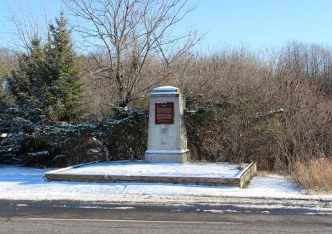
[front/devant]

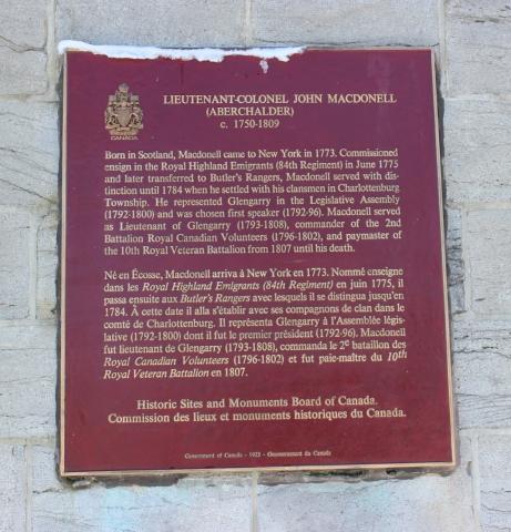
LIEUTENANT-COLONEL JOHN MACDONELL
(Aberchalder)
c. 1750 – 1809

Born in Scotland, Macdonell came to New York in 1773. Commissioned ensign in the Royal Highland Emigrants (84th Regiment) in June 1775 and later transferred to Butler’s Rangers, Macdonell served with distinction until 1784 when he settled with his clansmen in Charlottenburg Township. He represented Glengarry in the Legislative Assembly (1792 – 1800) and was chosen first speaker (1792 – 1796). Macdonell served as Lieutenant of Glengarry (1793 – 1808), commander of the 2nd Battalion Royal Canadian Volunteers (1796 – 1802), and paymaster of the 10th Royal Veteran Battalion from 1807 until his death.

Né en Écosse, Macdonell arriva à New York en 1773. Nommé enseigne dans les Royal Highland Emigrants (84th Regiment) en juin 1775, il passa ensuite aux Butler’s Rangers avec lesquels il se distingua jusqu’en 1784. À cette date il alla s’établir avec ses compagnons de clan dans le comté de Chalottenburg. Il représenta Glengarry à l’Assemblée législative (1792 – 1800) dont il fut le premier président (1792 – 1796). Macdonell fut lieutenant de Glengarry (1793 – 1808), commanda le 2e bataillon des Royal Canadian Volunteers (1796 – 1802) et fut paie-maître du 10th Royal Veteran Battalion en 1807.

Historic Sites and Monuments Board of Canada/Commission des lieux et monuments historiques du Canada Government of Canada – 1923 – Gouvernement du Canada

Image
Caption
front
1 of 2 images
Image
Caption
plaque
1 of 2 images
Province
!4v1624297714968!6m8!1m7!1sPccEHt2zqt5-r3p_ODv5KA!2m2!1d45.03957472651824!2d-74.61940830960637!3f144.47118214290754!4f-5.475114470046947!5f2.8767866485056115"
Body Content

This metal plaque on a stone cairn is dedicated to Lt.-Col John Macdonell, “Spanish John”. It was unveiled in 1923 by the Historic Sites and Monuments Board of Canada. He is the father of Captain Miles Macdonell.

City
Cornwall
Country
Type Description
Plaque, stone cairn
Photo Credit
Richard Turcotte
Memorial CF Legacy ID
8939
City/Municipality
Lunenberg
Memorial Number
35083-037
Type
Address
4725 County Road 12
Location
Memorial Hill Cemetery
in Canada
Yes
GPS Coordinates
45.0606217, -74.9602962
Inscription

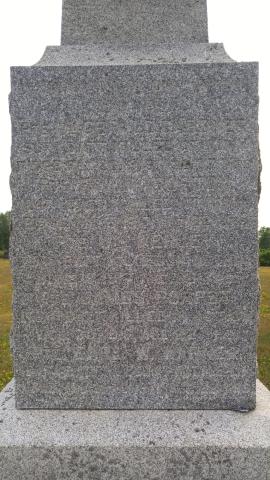
IN MEMORY OF OUR FALLEN
HEROES

PTE. WM GERALD GARDINER
50TH BATT. KILLED AT VIMY
RIDGE. FEB. 26, 1916 AGE 27 YRS.

PTE. FRANK BURTON
24TH BATT. KILLED AT VIMY
RIDGE, MAY 5, 1917 AGE 22YRS

PTE. WM WERLEY
75TH BATT. KILLED IN ACTION
JUNE 8, 1917 AGE 26 YRS.

PTE. JAMES POAPST
156TH BATT. KILLED IN ACTION
OCT. 30, 1917 AGE 22 YRS

PTE. EARL W. WARNER
154TH BATT. KILLED AT BATTLE OF
AMIENS. AUG. 10, 1918 AGE 20 YRS.

1914 - 1918


Image
Photo Credit
Louise Bellec
Caption
Lunenberg Cenotaph
1 of 3 images
Image
Photo Credit
Louise Bellec
Caption
inscription
1 of 3 images
Image
Photo Credit
Louise Bellec
Caption
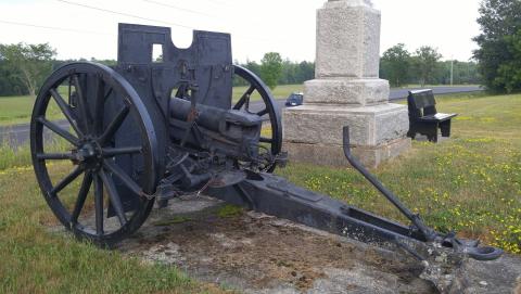
artillery
1 of 3 images
War or Conflict Term
Province
!4v1635770770619!6m8!1m7!1sPu6I_8LOZRkVVTsNnofSIw!2m2!1d45.06062660567282!2d-74.96028811651509!3f239.85288327014086!4f5.219771800807436!5f2.729218147401085"
Body Content

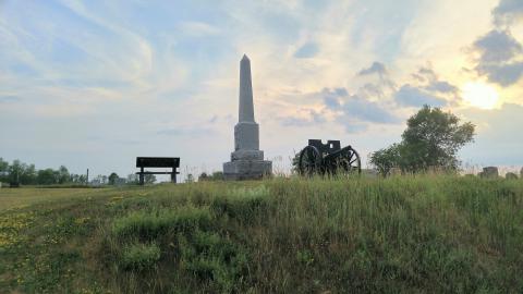
This memorial is dedicated to the First World War casualties from Lunenberg.

City
Lunenberg
Country
Type Description
Obelisk, artillery
Photo Credit
Nelson Mercier; Hélène Garand
Memorial CF Legacy ID
7022
City/Municipality
Morrisburg
Memorial Number
35083-036
Type
Address
8 5th Street West
Location
South Dundas Justice building
in Canada
Yes
GPS Coordinates
44.8989823, -75.1854701
Inscription

[front/devant]
IN MEMORY
OF THE MEN
OF MORRISBURG
AND VICINITY
WHO SERVED
IN THE
GREAT WAR
1914-18

[right side/côté droit]
GNR. DONALD BRADFIELD
C.O., G.M.S., C.H. GILLESPIE
SIGNR. GARNET E. LEWIS
SERGT. GERALD MEIKLE
CORP. ORLIN MERKLEY
N. SISTER F. MUNROE
SIGNR. DONALD PRUNER
LANCE CORP. E.R. STEEN
LIEUT. IVAN TINKESS
LIEUT. HUME WINGARD

[left side/côté gauche]
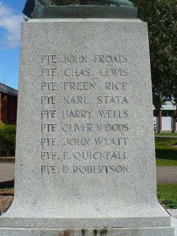
PTE. JOHN FROATS
PTE. CHAS. LEWIS
PTE. FREEN RICE
PTE. KARL STATA
PTE. HARRY WELLS
PTE. OLIVER WOODS
PTE. JOHN WYATT
PTE. F. QUICKFALL
PTE. D. ROBERTSON

[back/arrière]
THEIR BODIES
ARE BURIED IN PEACE,
BUT THEIR NAME
LIVETH FOREVERMORE

Image
Photo Credit
Richard Turcotte
Caption
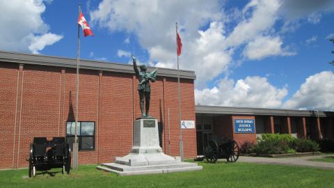
surroundings
1 of 6 images
Image
Photo Credit
Tim Laye, Ontario War Memorials
Caption
Soldier’s Monument
1 of 6 images
Image
Photo Credit
Tim Laye, Ontario War Memorials
Caption
front inscription
1 of 6 images
Image
Photo Credit
Tim Laye, Ontario War Memorials
Caption
right side inscription
1 of 6 images
Image
Photo Credit
Tim Laye, Ontario War Memorials
Caption
left side inscription
1 of 6 images
Image
Photo Credit
Tim Laye, Ontario War Memorials
Caption
back inscription
1 of 6 images
War or Conflict Term
Province
!4v1629812779380!6m8!1m7!1s118jWVG80aMsW-1Lu3Nuvg!2m2!1d44.89898018312749!2d-75.18544853861363!3f310.055043714566!4f4.1961164599192955!5f2.974757134134734
Body Content

The Morrisburg Soldiers' Monument Association was formed shortly after the First World War. This association pledged to erect a memorial to those who gave their lives in the war. The officers appointed were: Honorary President, Mr. Geo. W. Cook; Honorary Vice-President, Mr. I. Hilliard, K.C., M.P.P.; Chairman, Mr. W. K. Farlinger, Reeve; Mr. Leo Laurin, Editor of the Morrisburg Leader; Secretary, Miss Grace D. Merkley; Treasurer, Mr. Fred R. Chalmers, Town Clerk; Chairmen of Committees: Messrs. John Gormley; R.F. Lyle; Rev. Hugh Cameron; George L. Brown, C.E.; John H. Meikle; B.B. Tucker, C.E.; Arthur Flynn; and Fred Meikle.

This group successfully erected a beautiful monument costing $10,000 and executed by sculptor George William Hill, R.C.A. of Montreal. Standing nineteen feet high, its base is constructed of granite and is twelve feet square and nine feet high. A ten feet high bronze figure of an Infantry man, who having laid off his equipment of war, is in the act of acclaiming peace. His right arm is raised while he shouts the glad tidings, and with his left hand he presses the victorious flag to his heart. A wreath of laurel leaves, held against the flag, is a symbol of achievement. On the Die is placed the Dove of Peace, descending on the globe.

Over 5,000 people attended the unveiling of the war memorial on September 9, 1923. It was located on the municipal square, south-east corner of Main Street and Highway 31. A row of stately Lombardy poplars, planted by John H. Meikle, made a colourful background for the bronze figure. 

The memorial was relocated in April 1958 to the front of Morrisburg's Civic Building on 5th Street. When the soldier was moved from its original site by Luther Wells of Ingleside, workers found something unexpected. Placed in the foundation was a large glass bottle. J.H. Meikle, whose son Gerald was lost in the Great War in August of 1918, had arranged the contents. Four coins current at the time; the honour roll of those who had made the supreme sacrifice and those who had served overseas and honours won; a list of subscriptions to the monument fund including $2,000 from the Women’s Institute; and printed materials from various publications. When the monument was finally placed outside the Civic Centre, the bottle and its contents were again interred at the base of the cenotaph.

George William Hill was born in Shipton, Eastern Townships, in 1861. He learned to carve marble in his father’s company, after he graduated from college. Between 1889 and 1894, he left Quebec to study sculpting at the École nationale des beaux-arts and Académie Julian in Paris. When he returned to Montreal, he opened a studio and worked with architect Robert Findlay and brothers Edward and William S. Maxwell. Known for his public monuments and war memorials, he is now considered one of the most important Canadian sculptors of the early twentieth century.

Hill designed several monuments commemorating Canadians lost in the South African War, including the Strathcona and South African Soldiers' Memorial in Quebec and Boer War Soldiers Monument in Ontario. At the end of the First World War, Hill was awarded several contracts by towns and cities wishing to pay homage to citizens who had died on the battlefields. Between 1920 and 1930 he designed these monuments: Westmount Cenotaph, Magog Cenotaph, Argenteuil Cenotaph, Richmond Cenotaph, Sherbrooke War Memorial in Quebec; Pictou County War Memorial in Nova Scotia; Soldier's Monument, The Soldier and Nurses’ Memorial in Ontario; and the Soldier's Monument in Prince Edward Island.

City
Morrisburg
Country
Type Description
Shaft - granite, statue - bronze
Memorial CF Legacy ID
5553