Québec

Province Code
PQ
City/Municipality
Québec
Memorial Number
24051-090
Type
Address
Needs further research
Location
Place Royale
in Canada
Yes
GPS Coordinates
46.81269, -71.20226
Inscription

PLACE ROYALE
BERCEAU DE LA NOUVELLE-FRANCE
ICI SUR CE TERRAIN SAMUEL DE CHAMPLAIN FONDA QUÉBEC EN 1608.

Province
Body Content

This memorial is dedicated to Samuel de Champlain.

City
Québec
Country
Type Description
Ceramic plaque
Memorial CF Legacy ID
6097
City/Municipality
Québec
Memorial Number
24051-087
Type
Address
de Bernières street, George VI Avenue
Location
Located in Battlefields Park
in Canada
Yes
GPS Coordinates
46.8032599, -71.2184356
Inscription

CANON ALLEMAND
PRIS (SIC) 13 AVRIL 1917
AU BOIS DE FOLIE, CRETE DE VIMY, FRANCE,
ET UTILISÉ PAR LA SUITE CONTRE L’ENNEMI.
CANON ALLEMAND

GERMAN GUN
CAPTURED APRIL 13, 1917,
AT BOIS DE FOLIE, VIMY RIDGE, FRANCE,
AND USED AGAINST THE ENEMY.
GERMAN GUN

Province
Body Content

This memorial commemorates the First World War.

City
Québec
Country
Type Description
Plaque and a cannon
Memorial CF Legacy ID
6096
City/Municipality
Québec
Memorial Number
24051-085
Type
Address
170 Dalhousie Street
Location
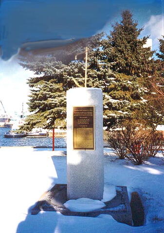
Behind the Naval Museum of Quebec
in Canada
Yes
GPS Coordinates
46.818234, -71.1996731
Image
Photo Credit
André Kirouac; Julie Fournier
Caption
front view
1 of 2 images
Image
Caption
plaque
1 of 2 images
War or Conflict Term
Province
!4v1620392749360!6m8!1m7!1sEPEktYqDvY8YnxscXUm69Q!2m2!1d46.81823396492818!2d-71.19967305103312!3f4.958853066163907!4f0.20763759542298033!5f3.325193203789971"
Body Content

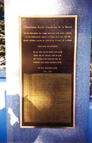
Erected by the Quebec/Lévis section of the Royal Canadian Naval Association, this memorial is dedicated to the sailors who died at sea during the Second World War.

City
Québec
Country
Type Description
Shaft
Memorial CF Legacy ID
6126
City/Municipality
Québec
Memorial Number
24051-084
Type
Address
Bernières street & George VI Avenue
Location
Battlefields Park
in Canada
Yes
GPS Coordinates
46.8032599, -71.2184356
Inscription

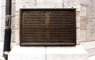
C’EST PAR UN SENTIER ABRUPT QUI SE TROUVAIT ICI QUE LES SOLDATS DE WOLFE RÉUSSIRENT A MONTER SUR LES PLAINES D’ABRAHAM, LE 13 SEPTEMBRE 1759.

ON THEIR MARCH TO THE PLAINS
OF ABRAHAM ON THE 13TH OF
SEPTEMBER, 1759, WOLFE’S
SOLDIERS BEGAN TO CLIMB THE
STEEP PATH HERE.

Province
Body Content

This memorial is dedicated to Wolfe's soldiers.

City
Québec
Country
Type Description
Plaque
Memorial CF Legacy ID
6114
City/Municipality
Québec
Memorial Number
24051-083
Type
Address
2 Jardins Street
Location
On the facade of the City Hall of Quebec City that is facing Sainte-Anne Street
in Canada
Yes
GPS Coordinates
46.81356, -71.20787
Inscription

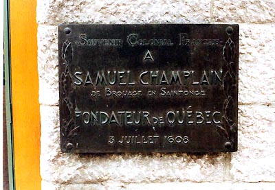
SOUVENIR COLONIAL FRANCAIS
A
SAMUEL CHAMPLAIN
DE BROUAGE EN SAINTONGE

FONDATEUR DE QUÉBEC
3 JUILLET 1608

Image
Photo Credit
Commission de la capitale nationale du Québec
Caption
plaque
Province
!4v1620390636926!6m8!1m7!1sCAoSLEFGMVFpcE9PYWQ3YTYzd1Q4dGdGYnh6b01wbUVuRnlia05xZUdGYjUwTl9n!2m2!1d46.813475!2d-71.20809170000001!3f108.96011434251665!4f3.488931738458234!5f1.77944846895776"
Body Content

This memorial is dedicated to Samuel de Champlain.

City
Québec
Country
Type Description
Plaque
Memorial CF Legacy ID
6113
City/Municipality
Québec
Memorial Number
24051-082
Type
Address
2 Jardins Street
Location
On the front corner of the City Hall of Quebec City
in Canada
Yes
GPS Coordinates
46.8135713, -71.2074115
Inscription

SUR CET EMPLACEMENT S’ÉLE-
VAIT LE COLLEGE DES JÉSUITES.
FONDÉ EN 1635, INCENDIÉ EN 1640,
REBATI EN 1647, CONSIDÉRABLE-
MENT AGRANDI EN 1725, OCCUPÉ
PARTIELLEMENT PAR LES TROUPES
ET L’ADMINISTRATION ANGLAISES DE
1759 A 1776, UTILISÉ COMME CASERNE
DE 1776 A 1871 ET DÉMOLI EN 1877.
L’ÉGLISE ATTENANTE QUI S’ÉTENDAIT
VERS LA RUE SAINTE-ANNE, FUT CONSTRUI-
TE EN 1666 ET DÉMOLIE EN 1807.

ON THIS SITE STOOD THE JE-
SUITS’ COLLEGE FOUNDED IN 1635.
DESTOYED BY FIRE IN 1640, RE-BUILT
IN 1647, CONSIDERABLY ENLARGED IN
1725, IT WAS OCCUPIED PARTLY BY BRI-
TISH TROOPS AND PUBLIC OFFICES, FROM
1759 TO 1776, AS A BARRACKS FROM
1776 TO 1871, AND FINALLY DEMOLISHED
IN 1877. THE CHURCH ATTACHED TO IT,
WHICH EXTENDED TOWARDS ST. ANNE
STREET, WAS ERECTED IN 1666, AND
DEMOLISHED IN 1807.

Image
Photo Credit
Commission de la capitale nationale du Québec
Caption
plaque
Province
!4v1620146898328!6m8!1m7!1sanvJsgbti5y7DzJcjNVz1w!2m2!1d46.81357131821311!2d-71.207411524765!3f271.9781074403704!4f0.8094057874088065!5f3.325193203789971"
Body Content

This memorial commemorates the historical importance of this location.

City
Québec
Country
Type Description
Plaque - bronze
Memorial CF Legacy ID
6112
City/Municipality
Québec
Memorial Number
24051-081
Type
Address
86 Saint-Louis Street
Location
Beside the front door
in Canada
Yes
GPS Coordinates
46.8103353, -71.2097428
Inscription

[plaque/plaque]

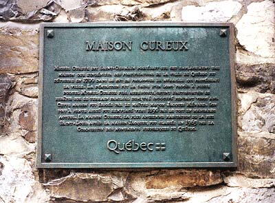
MAISON CUREUX

Michel Cureux dit Saint-Germain possédait sur cet emplacement une maison que l'ingénieur des fortifications de la Ville de Québec fit détruire en 1709 dans le but de prolonger la muraille qui protégeait la ville. La démolition fut la cause d'un long procès à l'issue duquel Michel Cureux fils, aubergiste, obtint l'autorisation de rebâtir sur le terrain familial demeuré inoccupé pendant vingt ans. Cette maison fut érigée par le maître maçon Jacques Ménard. Son toit à pente aiguë fut remplacé vers 1890 par le toit en mansarde actuel. La maison Cureux, la plus ancienne habitation de la rue Saint-Louis après la maison Jacquet, fut classée en 1965 par la Commission des monuments historiques du Québec.

Image
Photo Credit
Musée naval de Québec
Caption
plaque (front)
Province
!4v1616759911802!6m8!1m7!1s5JEPQwXm1M2fjlzI7N6c4Q!2m2!1d46.81033525798043!2d-71.20974283103277!3f287.8599340622423!4f-2.5524235292012207!5f2.299968626952992"
Body Content

This plaque commemorates the Maison Cureux, destroyed by the engineer of the Québec fortifications, in 1709, to be able to prolong the protective wall of the city. It brought on a long legal battle and Michel Cureux was able to rebuild elsewhere.

City
Québec
Country
Type Description
Plaque
Memorial CF Legacy ID
4176
City/Municipality
Québec
Memorial Number
24051-080
Type
Address
38 Petit Champlain Street
Location
On the facade of the building at 38 Petit Champlain Street
in Canada
Yes
GPS Coordinates
46.8121089, -71.2035834
Inscription

1643 1983

HOMMAGE

PIERRE ET GABRIEL LEMIEUX
(NÉS DE PIERRE-LOUIS ET MARIE LUGUEN)

VENUS DE ROUEN, NORMANDIE
S’ÉTABLIR EN CES LIEUX
EN 1643.

LEURS FILS SE RENDIRENT AVEC LOUIS JOLLIET
A LA BAIE D’HUDSON ET FURENT COMPAGNONS D’ARMES
DE PIERRE LEMOYNE D’IBERVILLE.

ILS ÉTAIENT DE CEUX:
"QUI DEVAIENT, LE MOUSQUET SUR L’ÉPAULE,
LE POING A LA CHARRUE OU LA HACHE A LA MAIN,
S’OUVRIR AU NOUVEAU-MONDE UN SI LARGE CHEMIN."
LOUIS FRÉCHETTE

Image
Photo Credit
Commission de la capitale nationale du Québec
Caption
plaque
Province
!4v1620223344357!6m8!1m7!1saXF3qI3abJ2mt4J2nbavYg!2m2!1d46.81210892264701!2d-71.20358337834809!3f216.54601753814993!4f-6.326700812852934!5f2.8911566846171413"
Body Content

This memorial erected by the Quebec Ministry of Cultural Affairs is dedicated to Pierre and Gabriel Lemieux.

City
Québec
Country
Type Description
Plaque
Memorial CF Legacy ID
6107
City/Municipality
Québec
Memorial Number
24051-079
Type
Address
2 Saint-Pierre Street
Location
Royal Battery landmark, on the backside of the building at 2 Saint-Pierre Street
in Canada
Yes
GPS Coordinates
46.8128016, -71.2019788
Inscription

GOUVERNEMENT DU QUÉBEC
MINISTERE DES AFFAIRES CULTURELLES

LA BATTERIE
ROYALE

Sous le règne de Louis XIV, en l’année 1691,
Frontenac, gouverneur général de la Nouvelle-France,
fait construire en ce lieu appelé Pointe-aux-Roches
une plate-forme qui doit recevoir une batterie de canons nécessaires
à la défense de Québec.

En 1763, ne servant plus à des fins militaires,
la batterie est transformée en débarcadère.
Au XIXe siècle, avec l’expansion du port et de la basse-ville,
elle disparaît peu sous les constructions et les remblayages successifs.
Remise à jour lors de fouilles archéologiques,
elle est restaurée en 1977.

Le 3 juillet 1978, 370e anniversaire de la capitale,
en présence du premier ministre, monsieur René Lévesque,
le ministre de la Culture et de la Communication,
monsieur Jean-Philippe, Lecat, remet, au nom du gouvernement français,
dix pièces d’artillerie de modèle 1733
à la Batterie Royale.

Image
Photo Credit
Commission de la capitale nationale du Québec
Caption
plaque
Province
!4v1617983522211!6m8!1m7!1sCAoSLEFGMVFpcE9KSzdIVk1EdkNhNWFqRkJWaHZZdVlpdEFDa2lNeERSbk9xTGtC!2m2!1d46.8128016!2d-71.20197879999999!3f19.726792438914767!4f6.830764332972208!5f2.299968626952992"
Body Content

This memorial erected by the Government of Quebec is dedicated to the Royal Battery.

City
Québec
Country
Type Description
Plaque
Memorial CF Legacy ID
6111
City/Municipality
Québec
Memorial Number
24051-078
Type
Address
101 Champlain Boulevard
Location
On the facade of the building next to the Canadian Coast Guard office
in Canada
Yes
GPS Coordinates
46.8103666, -71.2032745
Inscription

LE ROI LOUIS XV, EN 1746,
PRIT POSSESSION DE CET
EMPLACEMENT AFIN D’Y ÉTABLIR
UN NOUVEAU CHANTIER DE
CONSTRUCTION POUR SES
VAISSEAUX. LE GOUVERNEMENT
ANGLAIS Y ÉTABLIT SON PRE-
MIER BUREAU DE DOUANES
APRES LE CHANGEMENT DE
RÉGIME.

IN 1746, LOUIS XV, KING
OF FRANCE, TOOK POSSESSION
OF THIS AREA OF GROUND IN
ORDER TO ESTABLISH A NEW
SHIP-YARD FOR THE BUILDING
OF HIS VESSELS. HERE STOOD
THE FIRST CUSTOM HOUSE
ERECTED BY THE BRITISH
GOVERNMENT IN QUEBEC,
AFTER THE CESSION.

Image
Photo Credit
Commission de la capitale nationale du Québec
Caption
plaque
Province
!4v1620222689387!6m8!1m7!1sLmwhY0uCgawIQ-Ol09cCmA!2m2!1d46.81036660411753!2d-71.20327449179582!3f110.73974918299707!4f-1.201725818925496!5f3.325193203789971"
Body Content

This memorial commemorates the first custom house erected by the British government in Quebec after the cession.

City
Québec
Country
Type Description
Plaque - bronze
Memorial CF Legacy ID
6110