Parks

City/Municipality
Sarnia
Memorial Number
35071-042
Type
Address
145 Wellington Street
in Canada
Yes
GPS Coordinates
42.9693684, -82.4072146
Province
!4v1627566585187!6m8!1m7!1scr0uvS6Zf0XO1OjQidab1w!2m2!1d42.96936843905045!2d-82.40721455113612!3f41.75317191148712!4f-9.45750503814213!5f1.9587109090973311
Body Content

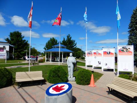
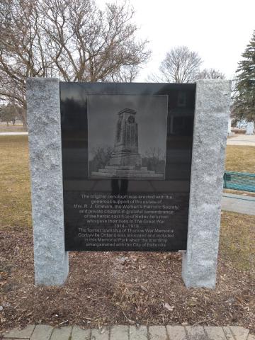
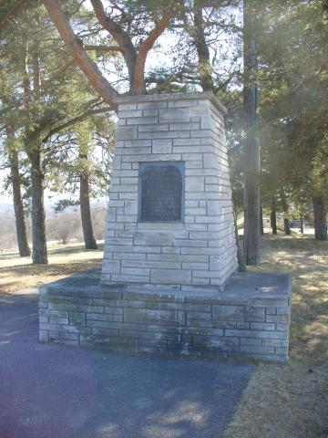
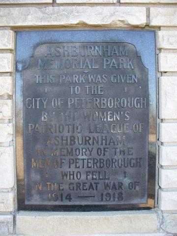
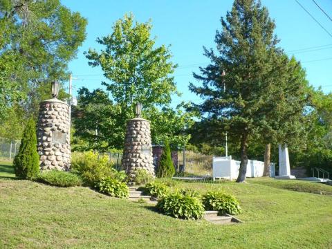
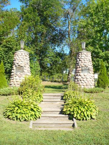
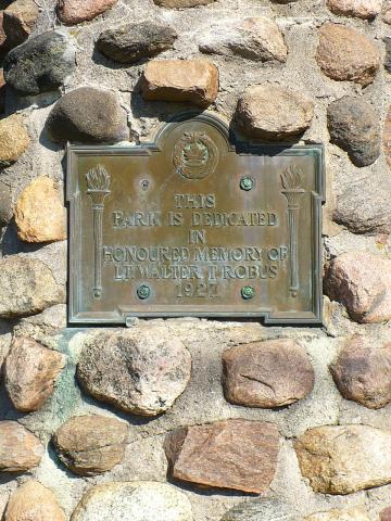
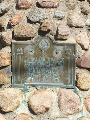
The park has a long historical connection with the military. It was used as a training ground for the local militia; a parade ground for thousands of soldiers stationed here during the Fenian raids of 1866; a marshaling ground for troops; a gathering place for troops before being sent off to war; a place for citizens to hold services to pray for the safe return of their family members; a place to celebrate when the soldiers first returned home from war; and a place to honour all those who served and sacrificed.

In October 1998, following a proposal by Mayor Mike Bradley, Sarnia City Council passed a motion endorsing that Victoria Park would be renamed Veterans Park, to reflect the history of the park and as a way to honour those who served. On Remembrance Day 1998, the park officially became known as Veterans Park. 

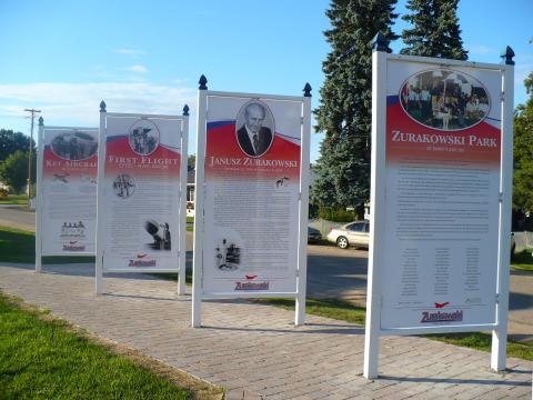
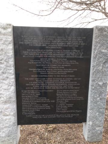
In late 2015, a committee of volunteers led by Lou Giancarlo and Tom Slater, brought forward the idea of creating a storyboard in Veterans Park. With support of Sarnia 1st Hussars Association and the City of Sarnia, the committee along with sign-maker Ken Hall, designed a storyboard that was installed in late October 2016. The storyboard provides a brief history of the park itself, and information on all of the military artifacts in the park. Along the bottom portion of the storyboard are eight photographs representing the wars commemorated on the memorials to the fallen in Veterans Park–the Boer War, First World War, Second World War (Army, Navy and Air Force), Korea War and Afghanistan.

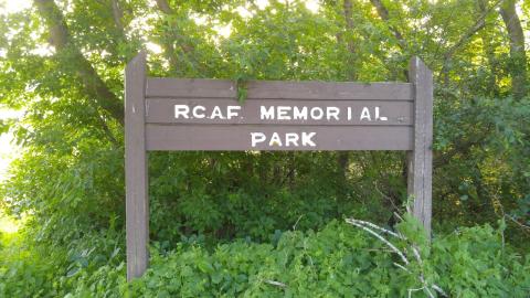
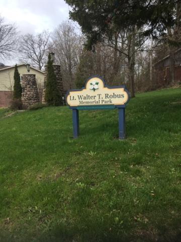
In August 2018, a new Veterans Park sign was added to the Park. It was created by Dave Beatty and paid for by Communities in Bloom Committee.

City
Sarnia
Country
Type Description
Park
Memorial CF Legacy ID
10540
City/Municipality
Petawawa (CFB)
Memorial Number
35070-093
Type
Address
Paardeberg Boulevard
Location
Canadian Forces Base Petawawa
in Canada
Yes
GPS Coordinates
45.9090374, -77.2831474
Inscription

needs further research/recherche incomplète

War or Conflict Term
Province
!4v1716920252365!6m8!1m7!1sMtX2YsGhwzx6j3LrvQbUZQ!2m2!1d45.90903743285093!2d-77.28314744311753!3f172.50301842750707!4f6.204962561788221!5f0.7820865974627469
Body Content

This park is named in honour of those who fought at the Battle of Paardeberg in the South African War.

City
Petawawa (CFB)
Country
Type Description
Park
Memorial CF Legacy ID
12498
City/Municipality
Renfrew
Memorial Number
35070-084
Type
Address
219 Hincks Avenue W
Location
RCAF Memorial Park
in Canada
Yes
GPS Coordinates
45.4760919, -76.6973788
Inscription

[park sign/enseigne du parc]
R.C.A.F. MEMORIAL
PARK

[memorial/monument]
IN MEMORY OF AIRMEN
KILLED ON ACTIVE SERVICE

DORZEK, A.A
BURWELL, A.J
JOHNSTON, W.S
SCOTT, L.G
JORDAN, H.C
MEREDITH, F
MC MAHON, J.A
STEWART, M.W
ST. LOUIS, J.C
BROWN, J.A
BROWN, W.L
GRACE, J.P
HALE, R.W
JOBSON, S.W
CRAM, M.
JONES, T.R

ERECTED BY 433 (CHAMPLAIN) WING
R.C.A.F. ASSOCIATION
RENFREW, ONTARIO 1968 A.D.

Image
Caption
RCAF Memorial Park sign
1 of 3 images
Image
Caption
inscription
1 of 3 images
Image
Caption
RCAF Memorial
1 of 3 images
Province
!4v1624381385998!6m8!1m7!1sq3am8SqAepFpYx4OcXNS9A!2m2!1d45.47605719839049!2d-76.69742240057238!3f236.46883840058584!4f-18.043561920412813!5f1.328232322912125"
Body Content

RCAF Memorial Park opened in 1968, and pays tribute to Renfrew airmen who were killed in the Second World War. Its memorial stands in the middle of the park near the river and consists of a flagpole and a concrete cairn resting on a cement support. Nearby is a tree commemorating the 60th anniversary of Renfrew's Royal Air Force Association.

City
Renfrew
Country
Type Description
Park
Photo Credit
Tim Laye, Ontario War Memorials
Memorial CF Legacy ID
10359
City/Municipality
Barry's Bay
Memorial Number
35070-082
Type
Address
83 Kelly Street
Location
Zurakowski Park
in Canada
Yes
GPS Coordinates
45.4882606, -77.677315
Inscription

needs further research/recherche incomplète

Image
Caption
Janusz Zurakowski statue
1 of 6 images
Image
Caption
storyboards (front)
1 of 6 images
Image
Caption
Zurakowski Park
1 of 6 images
Image
Caption
storyboards (back)
1 of 6 images
Image
Caption
CF-105 Avro Arrow
1 of 6 images
Image
Caption
Spitfire weathervane
1 of 6 images
War or Conflict Term
Province
!4v1703701542770!6m8!1m7!1sge_gGAmCLWpGj2GNW-jXtw!2m2!1d45.48826062894169!2d-77.67731498827443!3f-7.239676646786725!4f3.047993963636287!5f2.1593371301364894
Body Content

Janusz Zurakowski was one of the world's most famous pilots. He was a Polish Canadian who has been at the forefront of cutting edge aviation technology. Raised in Poland, he joined the Polish Air Force in 1934 and during the Second World War escaped to England in 1940. After a brilliant wartime career he test flew aircraft in England and Canada, to where he immigrated in 1952. The most notable aircraft he tested was the Canadian supersonic interceptor known as the CF-105 Avro Arrow.

The memorial features a statue of Janusz, a replica CF-105 Avro Arrow, a Spitfire weathervane, and several storyboards which explain Janusz's story and that of the Arrow. The park opened on July 26, 2003, shortly before he passed away in 2004.

In the summer of 2011, a 1/5 scaled down version of the Spitfire was added to the park. It is the same plane that Janusz flew during the Battle of Britain. The plane was built by Morris Towns from Madawaska and took more than 1,500 hours of labour to complete. When erected on its pole at the park, it moves on ball bearings like a wind sock. Because the plane was not constructed to withstand northern Canadian winters, it is stored for the cold months.

City
Barry's Bay
Country
Type Description
Park, statue, CF-105 Avro Arrow, Spitfire weathervane, storyboards
Photo Credit
Tim Laye, Ontario War Memorials
Memorial CF Legacy ID
10356
City/Municipality
Pembroke
Memorial Number
35070-068
Type
Address
1 Pembroke St E
Location
Pembroke Street and MacKay Street
in Canada
Yes
GPS Coordinates
45.8164803, -77.1087563
Inscription

Memorial Cenotaph Park

Image
Photo Credit
Victoria Edwards
Caption
Memorial Cenotaph Park, Pembroke
1 of 2 images
Image
Caption
Memorial Cenotaph Park, Pembroke
1 of 2 images
Province
!4v1624637529721!6m8!1m7!1samgsHK9yhmmIVDeSEPSyJA!2m2!1d45.82665562396674!2d-77.11110313291091!3f348.50137450129176!4f0.7858039694298355!5f3.325193203789971"
Body Content

Memorial Cenotaph Park is located on the corner of Pembroke Street East and Mackay Street, beside Pembroke's City Hall. Memorial Cenotaph Park is Pembroke's war memorial to all Canadian service men and women who have served and died in WWI, WWII, The Korean War and more recent battles in which the Canadian military has been engaged. Annual Remembrance Day services conducted by the Royal Canadian Legion Branch #72 are held every November 11th at 11:00 A.M.

Also see: Memorial Number: 35070-026


City
Pembroke
Country
Type Description
Park
Memorial CF Legacy ID
9428
City/Municipality
Cobden
Memorial Number
35070-028
Type
Address
35 Pembroke Street
Location
Veterans' Memorial Park, next to St. Andrews Presbyterian Church
in Canada
Yes
GPS Coordinates
45.6295752, -76.8810389
Inscription

[sign/enseigne]
Veterans'
Memorial Park

[plaque]
VETERANS’ MEMORIAL PARK

THIS PROPERTY WAS PURCHASED ON
NOVEMBER 15, 1904 BY
THE VILLAGE OF COBDEN FROM
THOMAS AND ELIZABETH ROBINSON FOR
THE SUM OF EIGHT HUNDRED DOLLARS

THE NINE LOTS LATER BECAME THE
VILLAGE OF COBDEN MUNICIPAL PARK
THIS PARK WAS RENAMED
VETERANS’ MEMORIAL PARK
ON JUNE 3, 2000

Image
Caption
plaque
1 of 2 images
Image
Caption
Veterans' Memorial Park sign
1 of 2 images
Province
!4v1708542718076!6m8!1m7!1snrU8-mYoPfnoy45YTeAF-g!2m2!1d45.62957518510068!2d-76.88103888475108!3f84.12882874582986!4f-9.64306094967182!5f0.7820865974627469
Body Content

This park was dedicated to all Veterans on June 3, 2000, by the Village of Cobden.

The Cobden Veterans Memorial and 427 Squadron Memorial Cenotaph are located in the park.

City
Cobden
Country
Type Description
Park, plaque
Photo Credit
Louise Bellec
Memorial CF Legacy ID
5087
City/Municipality
Belleville
Memorial Number
35069-052
Type
Address
10 Cannifton Road
Location
Memorial Park
in Canada
Yes
GPS Coordinates
44.174223, -77.3791614
Inscription

[sign/enseigne]

The original cenotaph was erected with the
generous support of the estate of
Mrs. R.J. Graham, the Women's Patriotic Society,
and private citizends in grateful remembrance
of the heroic sacrifice of Belleville's men
who gave their lives in The Great War
1914 - 1919
The former township of Thurlow War Memorial
Corbyville Ontario was relocated and included
in this Memorial Park when the townshop
amalgamated with the City of Belleville

[restoration sign]

Councillors George Beer, Cliff Belch, Paul Carr, Joe Cox,
Kay Manderville, Stu Meeks, Doug Parker and Mary Anne Sills

RESTORATION COMMITTEE MEMBERS
Chairman Robert B. Smith
Members Marvin W. Schmidt, John Hatter, Robert McLuskie,
Gerry Stoddard, John Gibson, and Douglas Moses
Director of Parks and Recreation

MAJOR CONTRIBUTORS TO THE PROJECT WERE
THE ARMY NAVY & AIR FORCE VETERANS IN CANADA, UNIT 201
ROYAL CANADIAN LEGION, BRANCH 99
418 WING ROYAL CANADIAN AIR FORCE ASSOCIATION
KOREA VETERANS ASSOCIATION, UNIT 9 AND
CITY OF BELLEVILLE, PARKS AND RECREATION DEPARTMENT

  • Bridge Street United Church Foundation
  • Lions Club of Belleville
  • Seniors Club 201 ANAF
  • Quinte Branch FSNA
  • Campbell Monument Company
  • Scott Wentworth Landscape Group
  • Canadian Auto Workers Union Local 1839
  • Maurice H. Rollins
  • Estate of WO1 Howard L. Kokesh
  • Donald & Eunice Matthews & Family
  • Marvin & Margaret Schmidt & Family
  • Gareth & Vivyan Edgard
  • John F. Charles
  • R. Max Haggerty
  • Quinte Veterans Association
  • Trillium Seniors Club 2000
  • Belleville Masonic Lodges
  • The Belleville Garden Club
  • Van Soelen Landscaptin Company
  • Service Employees Union Local 183
  • Thomas J. Bata
  • Eric Webster
  • G. Leighton Thompson
    Frank & Eileen Moore
  • Glenn R. Wylie
  • Lyle R. Ostrum
  • Stanley & Margaret Miller-Wiggins

THANKS ALSO TO THE CITIZENS OF BELLEVILLE AND THURLOW
WARD FOR THEIR SUPPORT FOR THIS PROJECT

Image
Photo Credit
City of Belleville
Caption
original cenotaph sign
1 of 2 images
Image
Photo Credit
City of Belleville
Caption
restoration sign
1 of 2 images
Province
!4v1623174339902!6m8!1m7!1sZc2siuc6QtamkYxBITAJGA!2m2!1d44.1742229729934!2d-77.37916140246134!3f327.752877946743!4f-3.7546280685613027!5f3.325193203789971"
Body Content

The original cenotaph located at this park was erected in 1932. In 2001, the Belleville Veterans Council and the City of Belleville replaced this cenotaph, relocated the Thurlow War Memorial here and refurbished Memorial Park.

City
Belleville
Country
Type Description
Park
Memorial CF Legacy ID
7313
City/Municipality
Ajax
Memorial Number
35068-019
Type
Address
96 Church Street North
in Canada
Yes
GPS Coordinates
43.8567105, -79.056475
Inscription

MEMORIAL PARK

War or Conflict Term
Province
!4v1647888139893!6m8!1m7!1s7zSmPNjITZOtOQD0X1lU1g!2m2!1d43.8567174532485!2d-79.0564799555219!3f254.46039611360158!4f-1.3131893548339093!5f2.1581439634889916
Body Content

In 1922, M.S. Chapman, William Gormley and J.R. Thexton of the Pickering Village Chamber of Commerce, purchased four and 3/8 acres of land from Thomas Walsh for $1,800 to use for a park. The citizens of Pickering Township donated money for its purchase in honour of the men who fought and died in the First World War.

Shortly after the park was purchased, the Memorial Park Gates and Cenotaph were erected. 

City
Ajax
Country
Type Description
Park
Memorial CF Legacy ID
10834
City/Municipality
Peterborough
Memorial Number
35067-029
Type
Address
Museum Drive
in Canada
Yes
GPS Coordinates
44.3118471, -78.3022247
Inscription

ASHBURNHAM
MEMORIAL PARK

THIS PARK WAS GIVEN
TO THE
CITY OF PETERBOROUGH
BY THE WOMEN'S
PATRIOTIC LEAGUE OF
ASHBURNHAM
IN MEMORY OF THE
MEN OF PETERBOROUGH
WHO FELL
IN THE GREAT WAR OF
1914 — 1918

Image
Caption
Ashburnham Memorial Park cairn
1 of 2 images
Image
Caption
inscription
1 of 2 images
War or Conflict Term
Province
!4v1624534478694!6m8!1m7!1s_5M6pd19WiuoGmcvdj5ODA!2m2!1d44.31184446995987!2d-78.30221023225542!3f195.5125694069059!4f-3.4818324500589597!5f3.325193203789971"
Body Content

The Ashburnham Women's Patriotic League bought Armour hill in 1923 as a park to be dedicated to the fallen of the First World War. Over the next few years, the league purchased saplings to be planted and commissioned the construction of a new road, now known as Museum Drive. 

In 1937, the League donated the land to the City of Peterborough as Ashburnham Memorial Park and in June of 1959, a memorial cairn and plaque were unveiled.

City
Peterborough
Country
Type Description
Park
Photo Credit
Tim Laye, Ontario War Memorials
Memorial CF Legacy ID
8568
City/Municipality
Norwood
Memorial Number
35067-013
Type
Address
47 Ridge Street
Location
Lt. Walter T. Robus Memorial Park
in Canada
Yes
GPS Coordinates
44.3827141, -77.9805947
Inscription

[park sign/enseigne du parc]

Lt. Walter T. Robus
Memorial Park

[left cairn/tumulus gauche]

THIS
PARK IS DEDICATED
IN
HONOURED MEMORY OF
LT. WALTER T. ROBUS
1927

[right cairn/tumulus droit]

LT. WALTER T. ROBUS
SERVED WITH THE 2nd BATT.
FROM 1914-1919
DIED IN TORONTO IN
HIS 32nd YEAR 1926

Image
Photo Credit
Tim Laye, Ontario War Memorials
Caption
park
1 of 6 images
Image
Photo Credit
Tim Laye, Ontario War Memorials
Caption
cairns
1 of 6 images
Image
Photo Credit
Tim Laye, Ontario War Memorials
Caption
left cairn plaque
1 of 6 images
Image
Photo Credit
Tim Laye, Ontario War Memorials
Caption
right cairn plaque
1 of 6 images
Image
Photo Credit
Township of Asphodel-Norwood
Caption
Lt. Walter T. Robus Memorial Park sign
1 of 6 images
Image
Caption
Lt. Walter T. Robus
1 of 6 images
Province
!4v1630425991128!6m8!1m7!1sx2ZXP3PE8LJnK-41WVe6qQ!2m2!1d44.38271410067445!2d-77.98059472166241!3f265.1136584937596!4f1.9595216254740961!5f3.325193203789971
Body Content

In 1927, Mrs. Kathleen Davidson, a wealthy Toronto hotel owner, purchased a lot for a memorial park in memory of Lieutenant Walter T. Robus (Tommie). This lot had an abandoned house that was demolished and replaced by two stone cairns with lights and plaques. The park was dedicated on August 15, 1927.

Tommie Robus was born to Henry Hunt Robus and Annie Louise Germain in Shoreditch, London, England on August 15, 18942. At the age of 17, he immigrated to Canada on February 25, 1911 and became a farm labourer in Norwood. Tommie had enlisted in Norwood on August 15, 1914, and had a successful military career in the First World War before being employed by Mrs. Davidson in the years prior to his death. While working at the hotel, Tommie told stories of the war to Kathleen and her daughter Shon. Kathleen was impressed and considered him a friend as well as an employee.

During the First World War, Tommie was at both the Battle of Neuve Chapelle and the Battle of St Julien. He was a member of the 1st  Brigade bomb throwers and also worked with the 10th Battalion. By June 7, he received a promotion to Corporal. On June 9, 1915, Tommie was wounded on the front at Festubert and Givenchy. He received a potato masher bomb in the jaw that cracked the jawbone, cut his mouth and broke teeth on one side. He spent about six weeks recuperating at the No. 2 Canadian General Hospital at Le Treport.

He was promoted to Lance Sergeant on November 15, 1915. Tommie's second injury occurred on January 1, 1916 at Wulverghem, Belgium when he received two gunshot wounds to his right thigh.  He returned to the French front on April 19, 1917. On June 2 at the Battle of Sorrel in Ypres, Tommie was again injured. He received shrapnel in his right shoulder and was on his back for about two weeks. Tommie was only deemed fit to return to France on November 8, 1917. He was promoted to Lieutenant on January 26, 1918, but did not return to the front until June 8 when he was part of the 2nd Canadian Battalion, 1st Canadian Brigade.

After participating in the Battle of Amiens he was injured near Arras. This time the injury was to his chest and again he was dangerously ill. After treatment, he was discharged on October 21.

On July 26, 1927, the Council in Norwood agreed to placing two plaques on the cobblestone cairns at the park entrance and to care for the memorial park.

City
Norwood
Country
Type Description
Park, cairns
Memorial CF Legacy ID
5702