Québec

Province Code
PQ
City/Municipality
Deux-Montagnes
Memorial Number
24060-008
Type
Address
141 Grand-Moulin Road
Location
In front of the Royal Canadian Legion
in Canada
Yes
GPS Coordinates
45.5434379, -73.8905448
Inscription

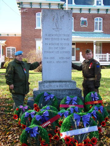
WE WILL
REMEMBER THEM
JE ME SOUVIENS
1914 - 1918
1939 - 1945
1950 - 1953

Image
Photo Credit
Ken Noble
Caption
surroundings
1 of 3 images
Image
Caption
details
1 of 3 images
Image
Caption
front view
1 of 3 images
Province
!4v1618506787806!6m8!1m7!1sPO-CccRDoJW5KIMAbFs6QQ!2m2!1d45.54343794830339!2d-73.89054484719324!3f153.6569885054788!4f1.3712327170691765!5f2.72519169480275"
Body Content

This memorial is dedicated to the fallen veterans of the First and Second World Wars and the Korean War. It was donated by Cde. R.B. Watson on October 29th, 1967.

City
Deux-Montagnes
Country
Type Description
Stele - granite
Memorial CF Legacy ID
5917
City/Municipality
Saint-Eustache
Memorial Number
24060-007
Type
Address
123 Saint-Louis Street
in Canada
Yes
GPS Coordinates
45.5586747, -73.8924546
Inscription

JE ME SOUVIENS

LE 14 DÉCEMBRE 1837, BATAILLE DE
SAINT-EUSTACHE ENTRE 150 PATRIOTES
COMMANDÉS PAR LE DOCTEUR CHÉNIER
ET 2000 SOLDATS SOUS LES ORDRES
DE SIR JOHN COLBORNE.

14 DECEMBER, 1837, BATTLE OF
ST. EUSTACHE BETWEEN 150 PATRIOTES
LED BY DR. CHÉNIER AND 2000 SOLDIERS
UNDER SIR JOHN COLBORNE.

COMMISSION DES MONUMENTS HISTORIQUES

Image
Photo Credit
Jacinthe Choinière
Caption
plaque
Province
Body Content

This memorial is dedicated to those who fought in the Battle of Saint-Eustache in December 1837. It was erected by the Quebec Historical Monuments Commission.

City
Saint-Eustache
Country
Type Description
Plaque - bronze
Memorial CF Legacy ID
5993
City/Municipality
Saint-Eustache
Memorial Number
24060-006
Type
Address
123 Saint-Louis Street
Location
Parish of Saint-Eustache
in Canada
Yes
GPS Coordinates
45.5575379, -73.8893556
Inscription

Nom du bâtiment: L'ÉGLISE DE SAINT-EUSTACHE
Adresse: 123, RUE SAINT-EUSTACHE
Date de construction: ABSIDE (1783)
FAÇADE ET MURS LATÉRAUX (1831)

RESTE DE L'ÉGLISE APRES 1840
Premier propriétaire: LA FABRIQUE DE SAINT-EUSTACHE
Principales utilisations: ÉGLISE ET SALLE D'ENREGISTREMENT

C’est le seigneur Dumont qui a donné en 1770 le terrain où se trouve la place de l’église. Achevée
en 1783, la première église avait la forme d’une croix latine. À partir de 1931, le curé Paquin
agrandit l’église et fait construire une façade en pierre de taille et deux superbes clochers.
Le 14 décembre 1837, lorsque l’armée britanique encercle le village, Chénier et une centaine de
Patriotes se réfugient dans l’église qui subit un bombardement violent.

Chénier et près d’une cinquantaine de Patriotes sont tués en sortant de cette forteresse en flammes.
L’église est rebâtie en 1840-41 à partir de ce qui restait, soit la façade, les deux tours, l’abside et
la partie inférieure des mûres latéraux. L’église est agrandie en 1905, puis rénovée en 1930. Le 30
juin 1970, l’édifice est classé monument historique. Lors du bicentenaire, en 1983, on effectue une
restauration majeure. Depuis 1980, l’église Saint-eustache accueille l‘Orchestre Symphonique
de Montréal en raison de son acoustique remarquable.

VILLE DE SAINT-EUSTACHE

Image
Photo Credit
Jacinthe Choinière
Caption
building
1 of 2 images
Image
Caption
plaque
1 of 2 images
Province
!4v1619626872136!6m8!1m7!1sZZE0fqFqMOQcL4suOxN9-g!2m2!1d45.55753785556712!2d-73.889355563639!3f137.2196417965468!4f20.23303404022424!5f0.9051500514049127"
Body Content

This memorial commemorates the Saint-Eustache Church which was used as a refuge in 1837.

City
Saint-Eustache
Country
Type Description
Building
Memorial CF Legacy ID
5992
City/Municipality
Saint-Eustache
Memorial Number
24060-005
Type
Address
145 Saint-Louis Street
Location
Saint-Eustache City Hall
in Canada
Yes
GPS Coordinates
45.5578524, -73.8890445
Inscription

Nom du bâtiment: LE COUVENT NOTRE-DAME
Adresse: 145, RUE SAINT-LOUIS
Date de construction: 1898
Premier propriétaire: LES DAMES DE LA CONGRÉGATION
Principales utilisations : COUVENT, COUR DE JUSTICE, ÉCOLE ET
ÉDIFICE ADMINISTRATIF MUNICIPAL

La construction du premier et second couvent a été entreprise par
le curé Jacques Paquin. En effet, dès son arrivée à Saint-Eustache en 1821, le nouveau pasteur
s’intéresse vivement à l’éducation. Avant la fin des années 1820, il commence la construction
d’un couvent
il s’agit d’un bâtiment en pierre à deux étages qui sera terminé en septembre 1836.
Les religieuses doivent l’inaugurer au début de 1838.

Les Patriotes en prennent possession le 1er décembre 1837 pour en faire leur quartier général.
Le 14 décembre 1837, plusieurs Patriotes s’y réfugient pour affronter l’armée et le bâtiment est
incendié. Reconstruit aussitôt, le couvent sert de chapelle de 1838 à 1840. De 1841 à 1849, la
bâtisse est louée et sert de cour de justice. Les Dames de la Congrégation s’y installent en
1849 et se dévouent à l’éducation des jeunes filles pendant plus de cent ans. L’édifice actuel date de
1898. Le couvent ferme ses portes en octobre 1980. La ville de Saint-Eustache en fait son
centre administratif en 1986.

VILLE DE SAINT-EUSTACHE

Image
Photo Credit
Jacinthe Choinière
Caption
front of building
1 of 2 images
Image
Caption
plaque
1 of 2 images
Province
!4v1615818500103!6m8!1m7!1sBl-inudMBDS0C2RR6zIzJA!2m2!1d45.55785236488522!2d-73.88904449469189!3f124.36315368476173!4f-0.4097800357901207!5f1.0815676993541843"
Body Content

This memorial commemorates the Notre-Dame Convent which was used as a refuge in 1837.

City
Saint-Eustache
Country
Type Description
Building
Memorial CF Legacy ID
5991
City/Municipality
Saint-Eustache
Memorial Number
24060-004
Type
Address
136 Saint-Louis Street
Location
Charles-Marsil House
in Canada
Yes
GPS Coordinates
45.5576566, -73.8892389
Inscription

Nom du bâtiment: LA MAISON MARSIL
Adresse: 136, RUE SAINT LOUIS
Date de construction: 1899-1919
Premier propriétaire: CHARLES-VICTOR-EMMANUEL MARSIL
Principales utilisations : RÉSIDENCE ET BUREAU

L’emplacement sur laquelle est construite cette maison a été concédé
en 1775 à André Lemaire. Après plusieurs changements de propriétaire, c’est le marchand
Jacques Dorion qui achète cette propriété, où se dresse une première maison. Ce dernier fait
agrandir cette maison de bois. En 1837, plusieurs Patrioes se réfugient à l’intérieur de cette
résidence qui sera incendiée par l’armée britannique.

La famille Dorion reste propriétaire de ce terrain vacant jusqu’en 1899. Acheté par le docteur
Charles-Victor-Emmanuel Marsil, celui-cifait construire la maison actuelle. En 1919, la vente au
chef de gare, Paul-Émile Paquin, confirme la présence d’une maison de bois et d’une laiterie.
La maison Marsil present plusieurs affinités avec les résidences de style américain du début
du XXe siècle. Son toit à trois versants, sa symétrie et la finesse de son ensemble représentent
ses principaux attraits.

VILLE DE SAINT-EUSTACHE

Image
Photo Credit
Jacinthe Choinière
Caption
side view
1 of 4 images
Image
Caption
rear view
1 of 4 images
Image
Caption
front view
1 of 4 images
Image
Caption
plaque
1 of 4 images
Province
!4v1619626363385!6m8!1m7!1sEQ1TEBasACR_2HbRi9tBUA!2m2!1d45.55765664012762!2d-73.88923894752304!3f316.9854914373588!4f1.3626227114502996!5f2.299968626952992"
Body Content

This memorial commemorates the house that served as a refuge in 1837.

City
Saint-Eustache
Country
Type Description
House
Memorial CF Legacy ID
5990
City/Municipality
Saint-Eustache
Memorial Number
24060-003
Type
Address
145 Saint-Louis Street
Location
In front of the Saint-Eustache City Hall
in Canada
Yes
GPS Coordinates
45.5579287, -73.8889714
Inscription

Ici repose les corps de dix Patriotes qui ont sacrifié leur vie
pour leur patrie le 14 décembre 1837 :

Joseph Paquet, 32 ans
Jean-Baptiste Lauzé, 25 ans
Nazaire Filion, 21 ans
Séraphin Doré, 29 ans
François Dubé, 29 ans

Joseph Guitard, 26 ans
Pierre Dubeau, 32 ans
Joseph Bouvret, 22 ans
Jean-Baptiste Toupin, 29 ans
Alexis Lachance, 17 ans


Jean-Olivier Chénier, 31 ans, a aussi été enterré ici de décembre 1837
à juin 1891. Il repose actuellement au cimetière de Saint-Eustache
depuis le 26 juilet 1987.

Ce cimetière a été bénit par monseigneur Charles Valois,
Évêque du diocèse de Saint-Jérôme, le 24 juin 1996.

La réalisation de cette plaque souvenir est l’oeuvre de :
La ville de Saint-Eustache
La Société Saint-Jean-Baptiste, section Jean-Olivier Chénier
L’Association Chénier de Saint-Eustache

Image
Photo Credit
Jacinthe Choinière
Caption
front view
1 of 2 images
Image
Caption
details
1 of 2 images
Province
!4v1615818059450!6m8!1m7!1sRqUZGtbA0E0VADokvWYDpg!2m2!1d45.55792870998753!2d-73.88897140076087!3f146.37561744797827!4f-12.927577402402207!5f2.299968626952992"
Body Content

This memorial is dedicated to the patriots killed in 1837. The plaque was erected by the City of Saint-Eustache, the Société Saint-Jean-Baptiste, Jean-Olivier-Chénier section, and the Chénier Association of Saint-Eustache.

City
Saint-Eustache
Country
Type Description
Plaque
Memorial CF Legacy ID
5989
City/Municipality
Saint-Eustache
Memorial Number
24060-002
Type
Address
123 Saint-Louis Street
Location
In front of the Parish of Saint-Eustache
in Canada
Yes
GPS Coordinates
45.5573458, -73.889541
Inscription

AUX
PATRIOTES
DE 1837

ÉRIGÉ PAR LES CITOYENS DU COMTÉ
DES DEUX MONTAGNES

Image
Photo Credit
Jacinthe Choinière
Caption
details
1 of 2 images
Image
Caption
front view
1 of 2 images
Province
!4v1619619602084!6m8!1m7!1sFE5CX4OTHcclqo8gFjxQYw!2m2!1d45.55734579371893!2d-73.88954099204314!3f125.85230081670493!4f-3.311484342856005!5f3.325193203789971"
Body Content

This memorial is dedicated to those who fought in 1837. It was erected by the citizens of the county of Deux Montagnes.

City
Saint-Eustache
Country
Type Description
Stele
Memorial CF Legacy ID
5988
City/Municipality
Sainte-Thérèse
Memorial Number
24060-001
Type
Address
40 Saint Louis Street
Location
Memorial Park
in Canada
Yes
GPS Coordinates
45.6414306, -73.8438941
Inscription

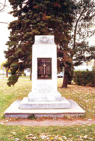
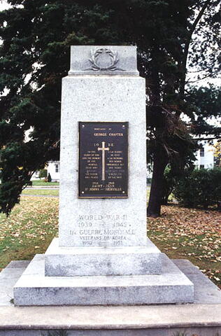
[front/devant]

JE ME SOUVIENS

1939 - 45

GEORGES FILIATREAULT
HERMENEGILES FORGET
MAURICE VUILLERMET
ROLAND DAUDELIN
MARCEL LONGPRÉ
DONCAN R.H. COWAN
KENNETH H. SALMON
ERNEST THERRIEN
GÉRARD VALLIÈRES
HENRI LESEIZE
P.E. BRISEBOIS
RUPER C. BURNS
H. PAUL DUGUAY
O. JODOIN
LÉO PAUL VIAU
C.A. HERMITAGE
H.R.D. PATTON
L. THORNTON

CORÉE
RÉMI MARTIN

LEST WE FORGET

Image
Photo Credit
Michel Litalien
Caption
stele (front)
1 of 2 images
Image
Caption
stele (surroundings)
1 of 2 images
War or Conflict Term
Province
!4v1615817599427!6m8!1m7!1s08G36ZQB3J6Lnb-uJdBR3Q!2m2!1d45.64143058046396!2d-73.84389409064035!3f269.2528328613042!4f-4.8118574932508835!5f2.396012076007615"
Body Content

This memorial is dedicated to the local war dead of the Second World War and the Korean War and is flanked by two Second World War-era anti-aircraft guns.

City
Sainte-Thérèse
Country
Type Description
Stele - granite
Memorial CF Legacy ID
3914
City/Municipality
Rouyn-Noranda
Memorial Number
24059-006
Type
Address
220 Mercier Avenue
Location
Inside the Ukrainian Catholic Church
in Canada
Yes
GPS Coordinates
48.2370027, -79.0252144
Image
Photo Credit
Victoria Edwards
Caption
Plaque
War or Conflict Term
Province
!4v1619797142489!6m8!1m7!1sdrBlXBvXvEB1qlooMr6Okg!2m2!1d48.23700268883719!2d-79.02521437362225!3f284.368556173596!4f18.519297882006796!5f0.9051948636238327"
Body Content

This memorial recalls a historic injustice Canadians should pause to remember, as we recall the First World War and the valour of all those Canadian men, and some women, who served. It is a tribute to mark the memory of the thousands of "enemy aliens" who had their civil rights stripped, and were subsequently imprisoned during Canada's first national internment operations of 1914-1920, following the implementation of the War Measures Act. 2014 marks the 100th anniversary of the War Measures Act - adopted on August 22, 1914 during the First World War. It was used to imprison Ukrainian-Canadians, and other ethnic groups, including German, Hungarian, Serbian, Croatian, and Armenian communities, into one of Canada's 24 internment camps.

Dr. Lubomyr Luciuk, a professor at the Royal Military College of Canada and former chair of the Ukrainian Canadian Civil Liberties Association (UCCLA), had taken it upon himself to lead the way and organize the memorial. In the CTO ("One Hundred") project, 100 aluminum plaques were simultaneously unveiled at 100 different locations across the country at 11:00am local time on August 22, 2014. The first plaque was unveiled in Amherst, Nova Scotia, followed by a wave of plaque unveilings moved west, from province to province, culminating in Nanaimo, British Columbia. The plaques, which cost $1,000 to make, were funded by the generosity of the Endowment Council of the Canadian First World War Interment Recognition Fund.

Each plaque features a photo of internment prisoners confined behind a wire fence at the Castle Mountain Internment Camp in Banff, Alberta. The Castle Camp, which was built in 1915 at the base of Castle Mountain, was a Canadian internment camp which held immigrant prisoners of Ukrainian, Austrian, Hungarian, and German descent.

City
Rouyn-Noranda
Country
Type Description
Plaque - aluminum
Memorial CF Legacy ID
8803
City/Municipality
Témiscaming
Memorial Number
24059-004
Type
Address
359 Kipawa Road
in Canada
Yes
GPS Coordinates
46.7191739, -79.0982265
Inscription

[front/devant][top plaque/plaque du haut]

JAMES J. HUNTER
JOSEPH H. MINESS
JOSEPH W. ROBINSON

[centre plaque/plaque du centre]

KOREAN WAR
MAY 1953
T. WOODBURY

[bottom/en bas]

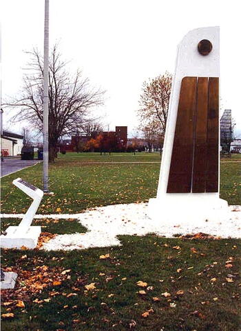
PLACE DES
VÉTÉRANS
PLACE

[side/côté]

A LA MEMOIRE
DES CITOYENS DE TEMISCAMING
TOMBES AU CHAMP D'HONNEUR
1939-45

[left column/colonne de gauche]

G. BAUMAN
A. COUSINEAU
K. FLEMING
D. McKAY
R. MONTGOMERY
J. M. VIOLETTE

[right column/colonne de droit]

E. R. BIETTE
E. FREVE
B. McGEE
L. McKENNA
W. G. RUST
S. WHYTE

[side/côté]

IN MEMORY
OF TEMISCAMING CITIZENS
WHO GAVE THEIR LIVES
IN THE WAR OF 1939-45

[left column/colonne de gauche]

G. BAUMAN
A. COUSINEAU
K. FLEMING
D. McKAY
R. MONTGOMERY
J. M. VIOLETTE

[right column/colonne de droit]

E. R. BIETTE
E. FREVE
B. McGEE
L. McKENNA
W. G. RUST
S. WHYTE

Image
Photo Credit
Simon Litalien
Caption
front
1 of 4 images
Image
Caption
surroundings
1 of 4 images
Image
Caption
English plaque
1 of 4 images
Image
Caption
French plaque
1 of 4 images
War or Conflict Term
Province
!4v1680804078279!6m8!1m7!1sI-EKwzHzwnYkvisIE4nqkQ!2m2!1d46.71917391110542!2d-79.09822646005851!3f353.65388531581647!4f3.673936693809665!5f3.325193203789971"
Body Content

 Needs further research

City
Témiscaming
Country
Type Description
Obelisk
Memorial CF Legacy ID
3955