Parks

City/Municipality
Bass River
Memorial Number
12002-065
Type
Address
5653 Highway 2
Location
Veterans Memorial Park
in Canada
Yes
GPS Coordinates
45.41516, -63.7778
Inscription

[front/devant]

WWI

WWII

Veterans Memorial Park Courage, Valour, Sacrifice

Korea

Afghanistan

Merchant Marine

Peacekeepers

Image
Photo Credit
Victoria Edwards
1 of 4 images
Image
1 of 4 images
Image
1 of 4 images
Image
1 of 4 images
Province
!4v1613138269119!6m8!1m7!1suifE2Mojh4OQ4RaQ_EW2hQ!2m2!1d45.41489873804947!2d-63.77766882710277!3f350.4421761586539!4f-2.9601169259062203!5f2.9913400178401916"
Body Content

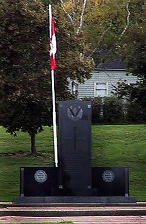
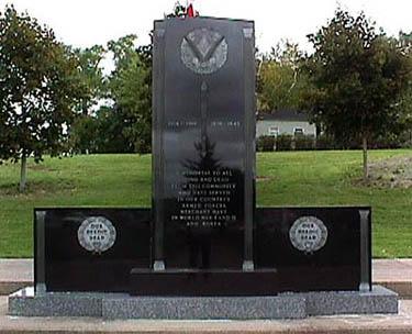
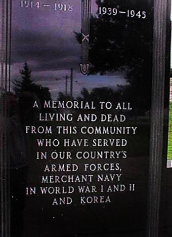
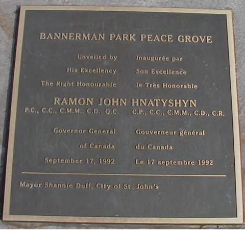
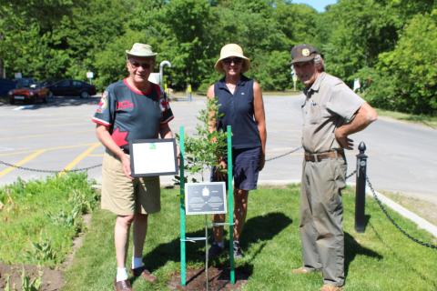
When local doctor Karen Ewing returned home after seeing WWI and WWII battlefields and memorials in Europe, she felt strongly that, since many people would not be travelling to Europe, there should be a memorial in Bass River. Dr. Ewing began with a letter campaign to all levels of government, as well as companies, organizations, and individuals that might be willing to donate funds or materials for such a park. She then approached Dominion Chair Co, a local company to ask for a piece of land that had remained vacant for years in the heart of Bass River. The memorial park is dedicated to remembering, honouring, and celebrating all men and women who served of are serving in Canada's military in conflicts past and present.

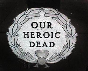
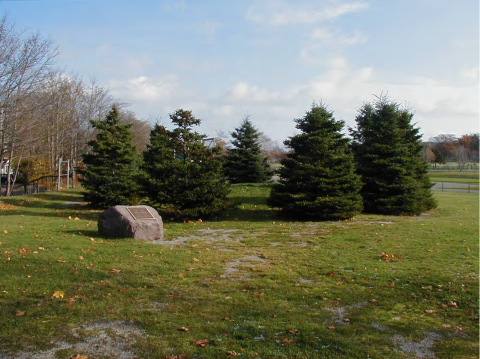
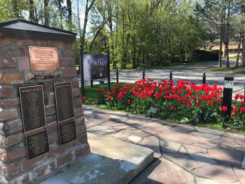
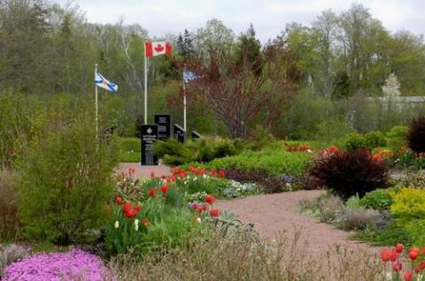
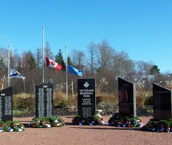
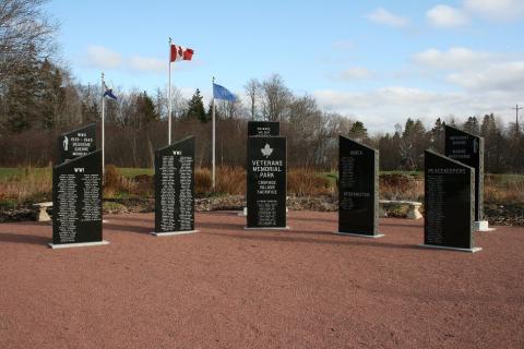
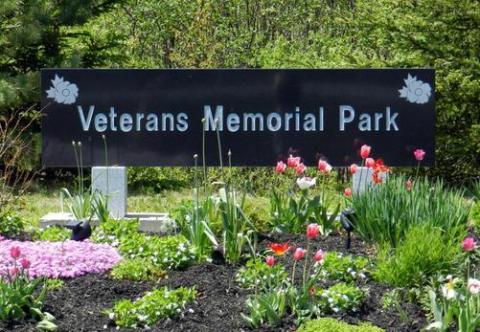
The Veterans Memorial Park (VMP) was designed by Dr. Karen Ewing in the form of a Celtic flower. The three gardens enfold eight black granite monuments set on red gravel. On the left is the Garden of Sorrows, formed as a mock WWI trench with no flowers and only black mulch and white sandbags. Behind the monuments is the Garden of Remembrance, with old-fashioned white and green shrubs, bulbs, perennials, and grasses. To the right is the Garden of Hope, in full colour, again filled with shrubs, bulbs and perennials from all around the world to inspire the visitors to look forward to the day when we will all live in peace with each other. The park is ringed by native trees with lawns and red gravel paths.

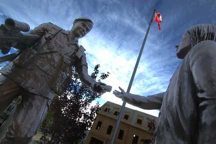
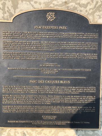
In addition to the black granite monuments, there are three stone benches dedicated to the families, the parents and the children who give so much when a family member goes away to serve. Behind the garden sits a sculpture, created and donated by a local welder, of the world surrounded by barbed wire. As the wire circles upward, it changes to olive branches and, at the tip, a peace dove takes flight. It is a symbol of our continued hope for peace.

Finally, there is a Forgotten Heroes monument, conceived of and donated by a local student. It is dedicated to the sacrifice of all the animals that have been used during war time and peace time.

City
Bass River
Country
Type Description
Park
Memorial CF Legacy ID
8535
City/Municipality
Sydney
Memorial Number
12001-087
Type
Address
583 Upper Prince Street
Location
Ashby Corner Park
in Canada
Yes
GPS Coordinates
46.1414944, -60.1743778
Inscription

[middle/centre]
1914 - 1918 1939 -1945

A MEMORIAL TO ALL
LIVING AND DEAD
FROM THIS COMMUNITY
WHO HAVE SERVED
IN OUR COUNTRY'S
ARMED FORCES,
MERCHANT NAVY
IN WORLD WAR I AND II
AND KOREA

[side/côté]
OUR
HEROIC
DEAD

Image
Photo Credit
Marilyn Gurney
Caption
front view
1 of 4 images
Image
Caption
front view
1 of 4 images
Image
Caption
inscription
1 of 4 images
Image
Caption
inscription
1 of 4 images
Province
!4v1612967459844!6m8!1m7!1s_kBPLR9DZDiEyaztnSnp0w!2m2!1d46.14146205914614!2d-60.17432372233188!3f122.53859236301763!4f0.450780613911931!5f3.325193203789971"
Body Content

This memorial is dedicated to those who served in Canada's Armed Forces, Merchant Navy in the First and Second World Wars.

City
Sydney
Country
Type Description
Park and stele
Memorial CF Legacy ID
6402
City/Municipality
Summerside
Memorial Number
11002-019
Type
Address
Summer, Spring, Church and Winter Streets
in Canada
Yes
GPS Coordinates
46.3938305, -63.7904502
War or Conflict Term
!4v1642007659096!6m8!1m7!1su8tbdzzfoiLO7GMOvFaGDQ!2m2!1d46.39383045222699!2d-63.79067406009455!3f74.28197720620261!4f12.199056558479597!5f0.7820865974627469
Body Content

Memorial Square, named in 1938 for its primary feature, the Prince County Soldiers’ Monument, is the oldest public park in the City of Summerside. The park's military connection dates back to 1866 when the Colonial Government purchased the land and erected a Drill Shed to house the local militia. The field adjoining the building became known as the Drill Shed Square until 1889 when the townspeople were given permission by the Canadian Government (PEI having joined Canada in 1873) to use the land as a Public Garden. The Drill Shed was destroyed in the Great Fire of 1906. In 1908, the Town of Summerside bought the property and three years later named it Dominion Square.

In 1920, two captured German field guns were placed in the square. These reminders of war set the tone for the erection in 1922 of a large memorial to commemorate Prince County men who lost their lives in the Great War. A granite stone was placed in front of the original monument in 1956 to record the names of those who died in the Second World War and the Korean War. In 2000, the British Commonwealth Air Training Plan Memorial was erected in the square.

A rejuvenation of the park was carried out between 2002 and 2004, with an emphasis on improving the area around the Soldiers’ Monument. Memorial Square is valued as a reminder of the sacrifices made by Islanders during past conflicts. For more information on Memorial Square visit Canada's Historic Places.

City
Summerside
Country
Type Description
Park
Memorial CF Legacy ID
10739
City/Municipality
St. John's
Memorial Number
10006-022
Type
Address
23 Rennies Mill Road
Location
Bannerman Park
in Canada
Yes
GPS Coordinates
47.5699445, -52.7088988
Inscription

Bannerman Park Peace Grove St John's

NAME

Peace Grove

LOCATION Bannerman Park at Circular Road

SIGNIFICANCE Dedicated by Governor General Ramon Hnatyshyn and Mayor Shannie Duff, September 17, 1992, in conjunction with Peace Parks across Canada and part of the CANADA 125 celebrations. Peace Parks across Canada resulted in the dedication of more than 400 peace parks in cities, towns, and villages across Canada. Most of the parks were dedicated on October 8th, 1992, at the same hour the National Peacekeeping Monument was being dedicated in the Canadian capital city of Ottawa.

Bannerman Park Peace Grove

unveiled by

His Excellency

The Right Honourable

Ramon John HNatyshyn

Governor General

of Canada

September 17, 1992

Mayor Shannie Duff, City of St John's


Image
Photo Credit
StJohns.ca
Caption
Bannerman Park Peace Grove
1 of 2 images
Image
Photo Credit
StJohns.ca
Caption
Bannerman Park Peace Grove
1 of 2 images
Body Content

Bannerman Park was dedicated St. John's "Peace Park" as part of Canada's 125th Birthday in 1992.

"Peace Parks Across Canada" was conceived and organized by the International Institute for Peace through Tourism (IIPT) in collaboration with "CANADA 125" and the National Capital Commission. As Canada celebrated its 125th Birthday, some 400 cities and towns across Canada dedicated a Park to Peace – with most parks dedicated at Noon local time, October 8th, as the National Peacekeeping Monument was being unveiled in Ottawa. The members of the winning design team included Cornelia H. Oberlander, landscape architect. Supporters included the Federation of Canadian Mayors and Municipalities, Canada Parks and Recreation Association, the Tourism Industry Association of Canada, Heritage Canada, World Wildlife Fund Canada, Friends of the Earth, Canadian Society of Landscape Architects, and local Rotary Clubs all across Canada. Project sponsors included VIA Rail, Greyhound Lines Canada, Ltd., CP Hotels and Resorts, Ramada International Hotels and Resorts, Four Seasons Ltd., Meridien Hotels, Concept 3 Advertising and Programmed Communications, Ltd.

Peace Parks Across Canada" has served as the foundation in launching the "IIPT Global Peace Parks Program" on the 11th hour, of the 11th day, of the 11th month, 2000

At noon on October 9th, 2007 – one day after the precise 15th Anniversary of the original dedications, and as Canada continues to be a beacon of peace, Tolerance, and Understanding in a world of increasing violence and distrust, and a nation that celebrates diversity, a nation-wide re-dedication was co-ordinated.

Each of the original Peace Parks incorporated a ‘Bosco Sacro’ (Peace Grove) of 12 trees as a symbolic link with one another, and with nature - and as a symbol of hope for the future. The 12 trees were also symbolic of Canada’s 10 Provinces and two Territories. As there are now three Territories, a 13th tree was planted as part of the "Re-dedication Ceremony."

City
St. John's
Country
Type Description
Park
Memorial CF Legacy ID
10137
City/Municipality
Gander
Memorial Number
10003-051
Type
Address
Airport Boulevard and Lindbergh Road
Location
Gander Heritage Memorial Park
in Canada
Yes
GPS Coordinates
48.9592475, -54.6155366
War or Conflict Term
!4v1726849311732!6m8!1m7!1s_Yst4rmHgOpDv-SmasoRWQ!2m2!1d48.95924754032252!2d-54.61553661517722!3f217.8082373656582!4f3.5392846196466365!5f0.7820865974627469
Body Content

The Gander Heritage Memorial Park was designed as a place of quiet thought and contemplation with various monuments reflecting the aviation and military history of the community. The walkways are laid out to mimic the runways at Gander Airport during the Second World War.

Included in the park: Sergeant Gander and his handler Memorial, Queens Own Rifles Memorial, Ferry Command Memorial, Memorial Wall of the 125th and Winged Victory.

City
Gander
Country
Type Description
Park
Memorial CF Legacy ID
12747
City/Municipality
Calgary
Memorial Number
48002-068
Type
Address
3031 Dallaire Avenue SW
in Canada
Yes
GPS Coordinates
51.0033214, -114.1270875
Inscription

[plaque]

PEACEKEEPERS PARK

Since the end of the Second World War, Canada has developed a strong peacekeeping tradition. At its heart are
the military personnel who serve their nation in its endeavour to assist people affected by war. These individuals
serve their country and the world community through their dedication to international peace and security. This
park is a tribute to Canada's Peacekeepers.

Peacekeepers Park includes three elements - the Wall of Honour and the Mission Wall to your left, and the bronze
sculpture before you. The Wall of Honour commemorates the Fallen Peacekeepers who made the ultimate
sacrifice. Their loss holds true as a symbol of the Canadian will to make the world a better place for all. The
second wall lists the Peacekeeping missions in which Canada has participated. The walls provide a testament
to the sacrifices and perseverance required to ensure peace.

The bronze sculpture shows an armed Canadian soldier offering an 'Izzy' doll to a little girl. During many of their
missions, Canada's Peacekeepers have been struck by the abject poverty and suffering of those less fortunate,
especially the children. This sculpture epitomizes the dual role of Canadian Peacekeepers in providing both
professional military intervention and compassion.

The Peacekeepers
We Will Remember Them.

Presented to Canada's Peacekeepers and The City of Calgary by Canada Lands Company CLC Limited
on Peacekeepers Day,
9 August 2004.
 

PARC DES CASQUES BLEUS

Depuis la fin de la Seconde Guerre mondiale, le Canada a établi une tradition solide de participation au maintien
de la paix. Les membres des Forces canadiennes sont au cœur de cette tradition volonté d'aider les gens affectés pars la
guerre. Par leur engagement à l'égard de la paix et de la sécurité dans le monde, ces hommes et ces femmes
servent à la fois leur pays et l'humanité. Ce parc est dédié aux casques bleus canadiens.

Le parc des casques bleus comporte trois éléments - le mur d’honneur et le mur de mission à votre gauche, et
la sculpture de bronze devant vous. Le mur d’honneur commémore les casques bleus qui ont fait le sacrifice
ultime. Leur mort symbolise la volonté du Canada d'améliorer la situation dans le monde. L'autre mur présente
les missions de maintien de la paix auxquelles le Canada a participé. Ces deux murs évoquent les sacrifices et
la persévérance nécessaires pour le maintien de la paix.

La sculpture de bronze représente un soldat canadien armé qui offre une poupée « Izzy » à une petite fille. Au
cours de leurs nombreuses missions, les casques bleus canadiens ont été frappés par la misère affreuse des
canadiens, qui offrent à la fois leur intervention militaire professionnelle et leur compassion.

A la mémoire des
Casques bleus

Présenté aux Casques bleus et à la ville de Calgary par la Société immobilière du Canada CLC limitée,
le Jour des Casques bleus, le 9 août 2004.

Image
Photo Credit
Veterans Affairs Canada
Caption
statue
1 of 2 images
Image
Photo Credit
Peacekeeper Park Committee
Caption
plaque
1 of 2 images
War or Conflict Term
Province
!4v1624360451740!6m8!1m7!1sFANcmSP21_ITPjaorA3pIA!2m2!1d51.00332136092034!2d-114.1270874869954!3f177.3866108645439!4f7.711215519008874!5f1.3185821271095521
Body Content

The 1.85 acre Peacekeepers Park is located in Garrison Green, the redeveloped Lincoln Park. This land was formerly part of Canadian Forces Base Calgary and, during the Second World War, was an airfield for the British Commonwealth Air Training Plan. After the base closed in 1998, the Canada Lands Company was tasked with redeveloping the land.

Peacekeepers Park features a Peacekeeper Statue, a Wall of Honour that pays tribute to those who lost their lives in the service of peace and a Missions Wall. The park was completed in 2004. The Canadian Association of Veterans in United Nations Peacekeeping, Calgary chapter provided guidance and input for the park and statue designs.  

Thirteen streets in Garrison Green are named after Canadian Peacekeepers of varying ranks and service time frames: Mike Ralph Way, Johnson Place, Angle Street, Couture Crescent, Forand Street, McLean Avenue, Tom Hoppe Mews, Lewis MacKenzie Place, Henwood Street, Joseph Marquis Crescent, John Gardham Avenue, Don Ethell Boulevard and Dallaire Avenue.

City
Calgary
Country
Type Description
Park
Memorial CF Legacy ID
9353
City/Municipality
Montréal
Memorial Number
24075-018
Type
Address
Saint-Jacques Street & Vinet Street
Location
D'Iberville Square, across the street from St. Cunigunde Church
in Canada
Yes
GPS Coordinates
45.4852805, -73.5767943
Inscription

SQUARE
D'IBERVILLE

Pierre Le Moyne, sieur d'Iberville
(1661-1706), militaire et explorateur

Ville de Montréal
ENTRETIEN 872-3434
ACCES INTERDIT DE 00h à 6h

Image
Photo Credit
Jacinthe Choinière
Caption
front view
Province
!4v1616601256997!6m8!1m7!1sM6wL8Yw3c68hqWs6YouhSw!2m2!1d45.48528046005838!2d-73.57679427243222!3f238.50818065417354!4f-2.235922160974411!5f1.9587109090973311"
Body Content

This memorial is dedicated to Pierre Le Moyne. It was erected by the City of Montreal.

City
Montréal
Country
Type Description
Park
Memorial CF Legacy ID
6037
City/Municipality
Hudson
Memorial Number
24072-007
Type
Address
56 Beach Street
in Canada
Yes
GPS Coordinates
45.4568934, -74.1371833
Inscription

[sign/enseigne]

PLACE
VIMY

1917 2017
HUDSON

LEGION

[plaque]
VIMY MCMXVII

Ayant grandi depuis les glands
de chênes pédonculés détruits lors de
la bataille de la crête de Vimy, cet arbre sert
a honorer les Canadiens qui ont servi lors de la
bataille de la crête de Vimy du 9 au 12 avril 1917.

Ce chêne a été planté et offert aux membres de la filiale
115 de Hudson de par le la Légion royale canadienne
par le député de Vaudreuil-Soulanges,
Peter Schiefke, le 28 septembre 2017.

Ne l'oublions jamais.

Grown from the acorns of
English Oaks destroyed during
the Battle of Vimy Ridge, this tree serves
to honour those Canadians who served in the
Battle of Vimy Ridge from April 9th - 12th, 1917.

Gifted and planted by MP for Vaudreuil-Soulanges,
Peter Schiefke, to the members of the Royal
Canadian Legion Hudson Branch 115
on September 28th, 2017.

Lest we forget.

Image
Photo Credit
Royal Canadian Legion Branch No. 115
Caption
Second World War Veterans Norm St. Aubin, Peter Stephenson, Maxine Bredt and piper Graham Batty at Place Vimy sign
1 of 6 images
Image
Photo Credit
Royal Canadian Legion Branch No. 115
Caption
Vimy Oak and plaque
1 of 6 images
Image
Photo Credit
Royal Canadian Legion Branch No. 115
Caption
surroundings
1 of 6 images
Image
Photo Credit
Royal Canadian Legion Branch No. 115
Caption
Planting second Vimy Oak, Rod Hodgson, Stephanie Thomas Morris and Mike Elliott.
1 of 6 images
Image
Photo Credit
Royal Canadian Legion Branch No. 115
Caption
surroundings and cenotaph
1 of 6 images
Image
Photo Credit
Royal Canadian Legion Branch No. 115
Caption
Vimy Oak
1 of 6 images
War or Conflict Term
Province
!4v1644323020154!6m8!1m7!1ssQW_YqkSQfQiOKXLEPQ4yQ!2m2!1d45.45689337007526!2d-74.13718332892645!3f5.836758585678843!4f0.9935765577581037!5f0.7820865974627469
Body Content

To commemorate the 100th anniversary of the Battle of Vimy Ridge, the Royal Canadian Legion Branch No. 115 unveiled its newly renovated cenotaph and surrounding park, now named Place Vimy, on August 17, 2017. 

Place Vimy was dedicated later on August 13, 2018. The twenty-five iron posts lined around the cenotaph were sponsored by people in the community. Each post has an inscription on it, in memory of loved ones. A new Place Vimy sign was erected at a central location in the gardens.

A Vimy Oak was planted on September 28, 2018, with Vaudreuil-Soulanges MP Peter Schiefke attending. On June 18, 2020, a new Vimy Oak was planted. A local area resident was kind enough to pick it up near Dundas, Ontario and deliver it.

The Place Vimy Bench is also located here.

City
Hudson
Country
Type Description
Park
Memorial CF Legacy ID
10759
City/Municipality
Shawinigan
Memorial Number
24067-002
Type
Address
884 St Maurice Parkway
in Canada
Yes
GPS Coordinates
46.5398781, -72.7535561
Image
Caption
Flagpole and flags sign.
1 of 5 images
Image
Caption
Veterans Park sign
1 of 5 images
Image
Caption
Veterans Park
1 of 5 images
Image
Caption
artillery
1 of 5 images
Image
Caption
artillery
1 of 5 images
Province
!4v1696426137728!6m8!1m7!1s0AKpfM7WxXp6axnCkIfH9Q!2m2!1d46.53987808891596!2d-72.75355614664497!3f245.72489494876567!4f2.61106648822674!5f0.7820865974627469
Body Content

Veterans Park

City
Shawinigan
Country
Type Description
Park
Photo Credit
Veterans Affairs Canada
Memorial CF Legacy ID
12050
City/Municipality
Shawville
Memorial Number
24049-006
Type
Address
146 Clarendon Street
Location
Shawville Veterans Memorial Park
in Canada
Yes
GPS Coordinates
45.6020685, -76.4862806
Inscription

[sign/enseigne]

SHAWVILLE VETERANS' PARK

Image
Photo Credit
D.B. Carrington
Caption
park (sign)
Province
!4v1621607091917!6m8!1m7!1s4-Q08GWL0Weyp8G7fjXfhg!2m2!1d45.60206848074431!2d-76.48628059103291!3f92.5621097906513!4f-3.7794583938557196!5f3.325193203789971"
Body Content

This park, the Shawville Veterans' Park, was erected by the town of Shawville.

City
Shawville
Country
Type Description
Park
Memorial CF Legacy ID
4056